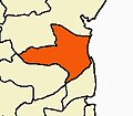
Srimushnam
This article needs additional citations for verification. (March 2012) |
Srimushnam | |
|---|---|
Town | |
 | |
 Srimushnam Location in Tamil Nadu, India | |
| Coordinates: 11°24′N 79°24′E / 11.400°N 79.400°E | |
| Country | |
| State | Tamil Nadu |
| District | Cuddalore |
| Taluk | |
| Area | |
| • Total | 15.72 km2 (6.07 sq mi) |
| Population (2011) | |
| • Total | 13,971 |
| • Density | 890/km2 (2,300/sq mi) |
| Languages | |
| • Official | Tamil |
| Time zone | UTC+5:30 (IST) |
| Vehicle registration | TN-91 |
Srimushnam is a town panchayat in, and the headquarters of , in Cuddalore district, Tamil Nadu, India. The town is sacred to Hindus and Buddhists. It is one of the eight Svayam Vyakta Ksetras of Vaishnavism, and is known for Bhu Varaha Swamy temple, which is dedicated to Varaha, the boar-avatar of Vishnu, and his consort, Lakshmi.[1][2]
Geography[]
Srimushnam is within Srimushnam taluk, which is in the southern part of Cuddalore district. It covers 15.72 square kilometres (6.07 sq mi) of land in the southwestern part of the taluk, near the border with Ariyalur district. Nearby large settlements include Virudhachalam, 15 km (9.3 mi) to the northwest, and Chidambaram, 30 km (19 mi) to the east. It is located 55 km (34 mi) southwest of Cuddalore, the district headquarters, and 200 km (120 mi) southwest of the state capital of Chennai. The town is within the drainage basin of the Vellar River.[3][4]
Demographics[]
In 2011 Srimushnam had a population of 13,971 people living in 3,277 households. 7,020 (50.2%) of the inhabitants were male, while 6,951 (49.8%) were female. 1,448 children in the town, about 10.4% of the population, were at or below the age of 6. 68.0% of the population was literate, with the male rate of 74.4% higher than the female rate of 61.6%. Scheduled Castes and Scheduled Tribes accounted for 18.9% and 0.56% of the population, respectively.[5]
References[]
- ^ https://cuddalore.nic.in/tourist-place/bhu-varaha-swamy-temple/
- ^ https://temple.dinamalar.com/en/new_en.php?id=788
- ^ "Cuddalore District Census Handbook (A)" (PDF). censusindia.gov.in. 2011. Retrieved 1 May 2021.
- ^ "Cuddalore District Map". 21 April 2021. Retrieved 1 May 2021.
- ^ "Cuddalore District Census Handbook (B)" (PDF). censusindia.gov.in. 2011. Retrieved 1 May 2021.
External links[]
| Wikimedia Commons has media related to Srimushnam. |
- Cities and towns in Cuddalore district


