Srirampura
Srirampura | |
|---|---|
Town | |
 BEML Nagar, Srirampura | |
| Coordinates: 12°11′32″N 76°39′55″E / 12.19222°N 76.66528°ECoordinates: 12°11′32″N 76°39′55″E / 12.19222°N 76.66528°E | |
| Country | |
| State | Karnataka |
| District | Mysore |
| Talukas | Mysore |
| Government | |
| • Body | Town Panchayat |
| Area | |
| • Total | 17.99 km2 (6.95 sq mi) |
| Population (2011) | |
| • Total | 18,511 |
| • Density | 1,000/km2 (2,700/sq mi) |
| Languages | |
| • Official | Kannada |
| Time zone | UTC+5:30 (IST) |
| ISO 3166 code | IN-KA |
| Vehicle registration | KA |
| Nearest city | Mysore |

Srirampura is a town and residential suburb of Mysore city in India. It is located in the Southern part of the city . It has a population of approximately 11,000 according to the 2011 Census. The main landmarks of this area are Brahmarahbha Choultrey, SBM park, Madhuvana Park. There are several schools in and around this area. North of Srirampura is Vivekananda Nagar and Kuvempunagar. West of Srirampura is Ramakrishnanagar, East of Srirampura is Asokapuram. South of Srirampura is the Mananthavady-Mysore Highway. In November 2020, a gazetted notification was passed upgrading the census town to a town panchayat.[1][2] The notification combines towns and villages of Srirampura, Lingambudhipalya, Gurur, Koppalur and Kalalavadi villages coming under Srirampura GP, covering a total area of 17.99 sq. km. [1] According to 2011 census, the town has a combined population of 18,511.[3]
Lingambudhi Lake[]

On the south western side of SRirampura, there is a lake called the Lingambudhi Lake. The Lingambudhi Lake is now a dry place with water hardly visible except on rainy season. The embankment of the lake is popular with tourists and fitness freaks. The lake is adjescent to posh residential colonies like Rabindranath Tagore Layout (R.T.Nagar).
Demographics[]
The town has combined population of 18,511 according to 2011 census. Population breakdown is given below.[4]
| Area Name | Population According to Census 2011 |
| Srirampura | 11234 |
| Lingambudi | 277 |
| Gurur | 2292 |
| Koppulur | 4327 |
| Kalavadi | 381 |
Suburbs of Srirampura[]
- Vivekananda Circle
- Mahadevapura
- SBM Colony
- Madhuvana Lalyout
- BEML Nagar
- Kandayanagara
- Surya layout
Bus Route from Mysore City[]
- K.G.Koppal - Apollo Hospitals - Akshya Bandar - Nrpathunga Road
- Karuna Hospital - Vivekanands Circle - IOB Srirampur
- Mother Teresa PU - Mahavir School - Vijaya Bank Srirampur - (Srirampur Last Bus stop)
Image gallery[]
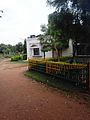
School in Srirampur
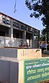
State Resource Center

Srirampur Highway

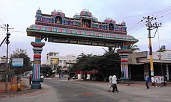
Ammari Amman Temple, Mananthavady Road


See also[]
- Jayaprakash Nagar Mysore
- Mysore South
References[]
- ^ a b "Hootagalli CMC and four Town Panchayats formed: Govt. issues Gazette notification". Star of Mysore. 26 November 2020. Retrieved 6 December 2020.
- ^ "Gazette Notification" (PDF).
- ^ "Census 2011 Handbook" (PDF).
- ^ "Census 2011 Handbook" (PDF).
- Mysore South