St. Olav's Church, Serampore
This article is missing information about denomination, status, diocese etc.. (March 2019) |
| St. Olav's Church | |
|---|---|
| সেন্ট ওলাভ'স চার্চ | |
 St.Olav's Church | |
 | |
| Location | 1 no., Church Road, Dr. Bishwanath Jot Sarani, Tin Bazar Serampore – 712201, West Bengal |
| Country | India |
| History | |
| Status | Active |
| Founded | 1806 |
| Founder(s) | Ole Bie |
| Dedication | Saint Olav |
| Architecture | |
| Functional status | Active |
| Completed | 1806 |
| Specifications | |
| Spire height | 25 metres (82 ft) |
St. Olav's Church (Bengali: সেন্ট ওলাভ'স চার্চ, romanized: Sēnṭa ōlābha'sa cārca) is a protestant church under the supervision of Church of North India (CNI) and the Serampore College Council. It is located in Serampore, West Bengal.[1]
History[]
Locally known as the Danish Church, it was one of the 100 buildings that were constructed by the Danish management between 1755 and 1845, at a time when the town was called Frederiksnagore.[2]
A major restoration project there was rewarded by the 2016 UNESCO Asia Pacific Heritage Awards[3]
Architecture[]
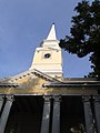
The entrance has an open portico of twin columns under a broken-base pediment containing the royal monogram of Christian VII, king of Denmark when the church was consecrated. Above the portico is a bell tower that also contains a clock. One of the church bells is inscribed "FREDERICKS VÆRCK ANNO 1804", indicating it originated from a Danish factory.[4]
The church is flat roofed, inside and out. The church is not particularly Scandinavian, but reflects the designs of contemporary churches in British India, in particular those in Calcutta, which were inspired by contemporaneous designs popular in Britain, such as St. Martin-in-the-Fields in London.[5]
Gallery[]
The Danish Church

Interior


References[]
- ^ "St. Olav's Church".
- ^ "Revisiting history: 210-year-old Danish church restored in West Bengal". India Today. Retrieved 16 October 2016.
- ^ 2016 UNESCO Asia-Pacific Heritage Award Winners
- ^ Serampore: Restaurering af Skt. Olavs Kirke, National Museum of Denmark.
- ^ Restoration of St. Olav's Church. National Museum of Denmark.
Further reading[]
- Chakraborty, Ajanta (7 April 2016). "Indo-Danish collaboration revives St Olav's from ruins". The Times of India.
- Chakraborty, Ajanta (8 February 2016). "Serampore church gets back lost glory". The Times of India.
- "210-Year-Old Danish Church To Reopen This Week Near Kolkata". NDTV. 11 April 2016.
- Chakraborty, Ajanta (6 September 2016). "Unesco honour for restoration of 210-year-old St Olav's Church". The Times of India.

- Churches in West Bengal
- Danish India
- Church of North India church buildings
- Churches completed in 1806
- Serampore