Stalewo
Stalewo | |
|---|---|
Village | |
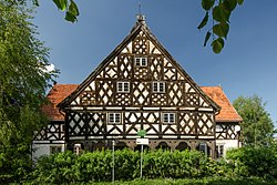 Mennonite timberframe house | |
 Stalewo | |
| Coordinates: 54°1′32″N 19°16′20″E / 54.02556°N 19.27222°ECoordinates: 54°1′32″N 19°16′20″E / 54.02556°N 19.27222°E | |
| Country | |
| Voivodeship | Warmian-Masurian |
| County | Elbląg County |
| Gmina | Markusy |
| Population | 178 |
| Time zone | UTC+1 (CET) |
| • Summer (DST) | UTC+2 (CEST) |
| Vehicle registration | NEB |
| Website | stalewo.blog.onet.pl |


Stalewo [staˈlɛvɔ] (German: Stalle)[1] is a village in the administrative district of Gmina Markusy, within Elbląg County, Warmian-Masurian Voivodeship, in northern Poland.[2] It lies approximately 8 kilometres (5 mi) west of Markusy, 12 km (7 mi) south-west of Elbląg, and 85 km (53 mi) west of the regional capital Olsztyn.
Stalewo was part of Poland, administratively located in the Malbork Voivodeship, before its annexation by Prussia in the First Partition of Poland in 1772. Afterwards from 1871 to 1945 it was also part Germany. Following Nazi Germany's defeat in World War II, the village was restored to Poland.
The village has a population of 178.
References[]
- ^ "Former Territory of Germany" (in German). 2017-11-08.
- ^ "Central Statistical Office (GUS) - TERYT (National Register of Territorial Land Apportionment Journal)" (in Polish). 2008-06-01.
This Elbląg County location article is a stub. You can help Wikipedia by . |
Categories:
- Villages in Elbląg County
- Elbląg County geography stubs