Stanmore Bay
Stanmore Bay | |
|---|---|
| Country | New Zealand |
| City | Auckland Council |
| Electoral ward | Albany ward |
| Population (2018) | |
| • Total | 12,165 |
| Red Beach | () | |
| Stillwater |
|
Manly |
| (Weiti River) | () |

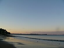
Stanmore Bay is a suburb and beach on the Whangaparaoa Peninsula, in the Auckland Region of New Zealand. The beach is on the northern side of the peninsula.[1]
The area was named Stanmore by a member of the Hill family who emigrated to New Zealand in 1853, because it reminded the family of Stanmore, England where they came from. The Hill family purchased 500 acres to farm but because it was only accessible by boat did not pursue farming there.[citation needed]

Demographics[]
| Year | Pop. | ±% p.a. |
|---|---|---|
| 2006 | 10,164 | — |
| 2013 | 11,106 | +1.27% |
| 2018 | 12,165 | +1.84% |
| Source: [2] | ||

Stanmore Bay, comprising the statistical areas of Vipond, Whangaparoa Central, Stanmore Bay West and Stanmore Bay East, had a population of 12,165 at the 2018 New Zealand census, an increase of 1,059 people (9.5%) since the 2013 census, and an increase of 2,001 people (19.7%) since the 2006 census. There were 4,401 households. There were 5,976 males and 6,198 females, giving a sex ratio of 0.96 males per female, with 2,424 people (19.9%) aged under 15 years, 2,340 (19.2%) aged 15 to 29, 5,598 (46.0%) aged 30 to 64, and 1,800 (14.8%) aged 65 or older.
Ethnicities were 88.7% European/Pākehā, 10.6% Māori, 2.8% Pacific peoples, 7.2% Asian, and 2.3% other ethnicities (totals add to more than 100% since people could identify with multiple ethnicities).
The proportion of people born overseas was 28.7%, compared with 27.1% nationally.
Although some people objected to giving their religion, 54.1% had no religion, 34.5% were Christian, and 4.4% had other religions.
Of those at least 15 years old, 2,070 (21.3%) people had a bachelor or higher degree, and 1,458 (15.0%) people had no formal qualifications. The employment status of those at least 15 was that 5,160 (53.0%) people were employed full-time, 1,485 (15.2%) were part-time, and 300 (3.1%) were unemployed.[2]
Education[]
Whangaparaoa College is a secondary (years 7-13) school with a decile rating of 9[3] and a roll of 1604[4] (March 2021). The college opened at the beginning of 2005, incorporating Hibiscus Coast Intermediate School.[5] It was initially called Stanmore Bay Secondary School.[6]
Stanmore Bay School is a contributing primary (years 1-6) school with a decile rating of 8[7] and a roll of 617[4] (March 2021). The school celebrated its 25th Jubilee in 2004.[8]
Both schools are coeducational.
Notes[]
- ^ Peter Dowling (editor) (2004). Reed New Zealand Atlas. Reed Books. pp. map 11. ISBN 0-7900-0952-8.CS1 maint: extra text: authors list (link)
- ^ Jump up to: a b "Statistical area 1 dataset for 2018 Census". Statistics New Zealand. March 2020. Vipond (114400), Stanmore Bay West (114600), Whangaparoa Central (114900) and Stanmore Bay East (115100). 2018 Census place summary: Vipond 2018 Census place summary: Stanmore Bay West 2018 Census place summary: Whangaparoa Central 2018 Census place summary: Stanmore Bay East
- ^ Education Counts: Whangaparaoa College
- ^ Jump up to: a b "New Zealand Schools Directory". New Zealand Ministry of Education. Retrieved 27 April 2021.
- ^ "Education Review Report - Whangaparaoa College". Education Review Office. July 2007. Retrieved 27 August 2008.[dead link]
- ^ "Mergers, Closures and New Schools, January 2005 - December 2005" (XLS). Education Counts.
- ^ Education Counts: Stanmore Bay School
- ^ "Stanmore Bay School 25th Jubilee Celebration". Education Gazette New Zealand. 83 (8). 10 May 2004.
External links[]
- Whangaparaoa College website
- Stanmore Bay School website
- Photographs of Stanmore Bay held in Auckland Libraries' heritage collections.

- Rodney District
- Suburbs of Auckland
- Beaches of Auckland