Stapleton station
Stapleton | |||||||||||||||||||||||||||||||||||||||||||||||||||||||||||||||||||||||||||
|---|---|---|---|---|---|---|---|---|---|---|---|---|---|---|---|---|---|---|---|---|---|---|---|---|---|---|---|---|---|---|---|---|---|---|---|---|---|---|---|---|---|---|---|---|---|---|---|---|---|---|---|---|---|---|---|---|---|---|---|---|---|---|---|---|---|---|---|---|---|---|---|---|---|---|---|
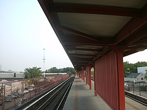 Station platform | |||||||||||||||||||||||||||||||||||||||||||||||||||||||||||||||||||||||||||
| Station statistics | |||||||||||||||||||||||||||||||||||||||||||||||||||||||||||||||||||||||||||
| Address | Bay Street & Prospect Street Staten Island, NY 10304 | ||||||||||||||||||||||||||||||||||||||||||||||||||||||||||||||||||||||||||
| Borough | Staten Island | ||||||||||||||||||||||||||||||||||||||||||||||||||||||||||||||||||||||||||
| Locale | Stapleton | ||||||||||||||||||||||||||||||||||||||||||||||||||||||||||||||||||||||||||
| Coordinates | 40°37′40″N 74°04′31″W / 40.627889°N 74.075139°WCoordinates: 40°37′40″N 74°04′31″W / 40.627889°N 74.075139°W | ||||||||||||||||||||||||||||||||||||||||||||||||||||||||||||||||||||||||||
| Division | [1] | ||||||||||||||||||||||||||||||||||||||||||||||||||||||||||||||||||||||||||
| Services | Local | ||||||||||||||||||||||||||||||||||||||||||||||||||||||||||||||||||||||||||
| Transit | |||||||||||||||||||||||||||||||||||||||||||||||||||||||||||||||||||||||||||
| Structure | Elevated | ||||||||||||||||||||||||||||||||||||||||||||||||||||||||||||||||||||||||||
| Platforms | 1 island platform | ||||||||||||||||||||||||||||||||||||||||||||||||||||||||||||||||||||||||||
| Tracks | 2 | ||||||||||||||||||||||||||||||||||||||||||||||||||||||||||||||||||||||||||
| Other information | |||||||||||||||||||||||||||||||||||||||||||||||||||||||||||||||||||||||||||
| Opened | July 31, 1884[2] | ||||||||||||||||||||||||||||||||||||||||||||||||||||||||||||||||||||||||||
| Rebuilt | 1936 | ||||||||||||||||||||||||||||||||||||||||||||||||||||||||||||||||||||||||||
| Station code | 503[3] | ||||||||||||||||||||||||||||||||||||||||||||||||||||||||||||||||||||||||||
| Station succession | |||||||||||||||||||||||||||||||||||||||||||||||||||||||||||||||||||||||||||
| Next north | Tompkinsville | ||||||||||||||||||||||||||||||||||||||||||||||||||||||||||||||||||||||||||
| Next south | Clifton | ||||||||||||||||||||||||||||||||||||||||||||||||||||||||||||||||||||||||||
| |||||||||||||||||||||||||||||||||||||||||||||||||||||||||||||||||||||||||||
| |||||||||||||||||||||||||||||||||||||||||||||||||||||||||||||||||||||||||||
| |||||||||||||||||||||||||||||||||||||||||||||||||||||||||||||||||||||||||||


Stapleton is an elevated Staten Island Railway station in the neighborhood of Stapleton, Staten Island, New York, located at Bay Street and Prospect Street on the main line.
History[]
This station opened on July 31, 1884, with the extension of the SIRT from Vanderbilt's Landing to Tompkinsville.[2] Stapleton was rehabilitated in 1936 as part of a grade crossing elimination project.[4]
Station layout[]
| P Platform level |
Southbound | ← ← |
| Island platform | ||
| Northbound | | |
| G | Street level | Exit/entrance |
The station has an island platform and two tracks. South of the station, tracks diverge from the line on the Saint George-bound side to the Clifton Yard.[5] This is where the railway cars are moved from the Staten Island Railway by truck to get work done at the Coney Island Shops.
Exits[]
The north end has an exit to Prospect Street and a New York City Department of Transportation Park and Ride facility to the west side of the right-of-way (next to Bay Street).[6][7] The south end exits to Water Street and Bay Street.[4][6]
References[]
- ^ "Glossary". Second Avenue Subway Supplemental Draft Environmental Impact Statement (SDEIS) (PDF). Vol. 1. Metropolitan Transportation Authority. March 4, 2003. pp. 1–2. Archived from the original (PDF) on February 26, 2021. Retrieved January 1, 2021.
- ^ a b Irvin Leigh and Paul Matus (December 23, 2001). "SIRT The Essential History". p. 6. Retrieved March 3, 2009.
- ^ "Station Developers' Information". Metropolitan Transportation Authority. Retrieved June 13, 2017.
- ^ a b "Google Maps".
- ^ "Google Maps".
- ^ a b "Map of NYC Subway Entrances". NYC Open Data. City of New York. Retrieved July 10, 2018.
- ^ "Google Maps".
External links[]
 Media related to Stapleton (Staten Island Railway station) at Wikimedia Commons
- Staten Island Railway station list
- Staten Island Railway general information
- Platform from Google Maps Street View
- Staten Island Railway stations
- Railway stations in the United States opened in 1884
- 1884 establishments in New York (state)
- Stapleton Heights, Staten Island