Staufenberg, Lower Saxony
Staufenberg | |
|---|---|
 | |
 Coat of arms | |
show Location of Staufenberg within Göttingen district | |
 Staufenberg | |
| Coordinates: 51°21′00″N 09°35′59″E / 51.35000°N 9.59972°ECoordinates: 51°21′00″N 09°35′59″E / 51.35000°N 9.59972°E | |
| Country | Germany |
| State | Lower Saxony |
| District | Göttingen |
| Government | |
| • Mayor | Bernd Grebenstein |
| Area | |
| • Total | 77.55 km2 (29.94 sq mi) |
| Elevation | 288 m (945 ft) |
| Population (2020-12-31)[1] | |
| • Total | 7,724 |
| • Density | 100/km2 (260/sq mi) |
| Time zone | UTC+01:00 (CET) |
| • Summer (DST) | UTC+02:00 (CEST) |
| Postal codes | 34355 |
| Dialling codes | 05543 |
| Vehicle registration | GÖ |
| Website | www.staufenberg-nds.de |
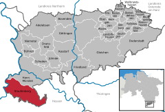


Staufenberg is the southernmost municipality of the district of Göttingen, and of Lower Saxony, Germany. It is situated east of the river Fulda, approx. 6 km south of Hannoversch Münden, and 12 km northeast of Kassel. Its seat is in the village Landwehrhagen.
Points of interest[]
References[]
| show Towns and municipalities in Göttingen (district) |
|---|
| Authority control |
|---|
This Göttingen district location article is a stub. You can help Wikipedia by . |
Categories:
- Municipalities in Lower Saxony
- Göttingen (district)
- Göttingen district geography stubs