Stedum
Stedum | |
|---|---|
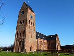 Bartholomeuskerk in 2011 | |
 Stedum Location of Stedum in the province of Groningen | |
| Coordinates: 53°19′21″N 6°41′45″E / 53.32250°N 6.69583°E | |
| Country | Netherlands |
| Province | Groningen |
| Municipality | Eemsdelta |
| Population (1 January 2006) | 1,100 |


Stedum, road panorama Delleweg
Stedum (Dutch pronunciation: [ˈsteːdɵm]) is a village in the Dutch province of Groningen. It is located in the municipality of Eemsdelta, about 15 km northeast of the city of Groningen.
Stedum was a separate municipality until 1990, when it was merged with Loppersum.[1]
The German Hohenhameln municipality, which includes the German village Stedum, was twinned with the Dutch municipality Loppersum.
References[]
- ^ Ad van der Meer and Onno Boonstra, Repertorium van Nederlandse gemeenten, KNAW, 2011.
External links[]
- J. Kuyper, Gemeente Atlas van Nederland, 1865-1870, "Stedum". Map of the former municipality, around 1868.
 Media related to Stedum at Wikimedia Commons
| hide Authority control | |
|---|---|
| General |
|
| National libraries | |
Coordinates: 53°19′N 6°42′E / 53.317°N 6.700°E
This Groningen location article is a stub. You can help Wikipedia by . |
Categories:
- Populated places in Groningen (province)
- Former municipalities of Groningen (province)
- Eemsdelta
- Groningen (province) geography stubs