Steeple Rock (Washington)
| Steeple Rock | |
|---|---|
 Steeple Rock seen from the east | |
| Highest point | |
| Elevation | 5,567 ft (1,697 m)[1] |
| Prominence | 567 ft (173 m)[1] |
| Coordinates | 47°57′43″N 123°27′15″W / 47.961935°N 123.454043°WCoordinates: 47°57′43″N 123°27′15″W / 47.961935°N 123.454043°W[1] |
| Geography | |
 Steeple Rock Location of Eagle Point in Washington | |
| Location | Clallam County, Washington, United States |
| Parent range | Olympic Mountains |
| Topo map | USGS Mount Angeles |
| Geology | |
| Age of rock | Eocene |
| Type of rock | Basalt |
| Climbing | |
| Easiest route | Scrambling class 3 |


Steeple Rock[2] is a 200 feet (61 m) basalt pillar in the Olympic Mountains, and is located in Clallam County of Washington state. It sets next to the Obstruction Point Road on Hurricane Ridge within Olympic National Park. It's situated midway between Eagle Point and the Hurricane Ridge Visitor Center. Precipitation runoff drains into tributaries of the Elwha River and Morse Creek, thence into the Strait of Juan de Fuca.
Climate[]
Set in the north-central portion of the Olympic Mountains, Steeple Rock is located in the marine west coast climate zone of western North America. Most weather fronts originate in the Pacific Ocean, and travel northeast toward the Olympic Mountains. As fronts approach, they are forced upward by the peaks of the Olympic Range, causing them to drop their moisture in the form of rain or snowfall (Orographic lift). As a result, the Olympics experience high precipitation, especially during the winter months in the form of snowfall. During winter months, weather is usually cloudy, but, due to high pressure systems over the Pacific Ocean that intensify during summer months, there is often little or no cloud cover during the summer. Because of maritime influence, snow tends to be wet and heavy, resulting in high avalanche danger.
Geology[]
The Olympic Mountains are made up of obducted clastic wedge material and oceanic crust. They are primarily Eocene sandstones, turbidites, and basaltic oceanic crust.[3] Unlike the Cascades, the Olympic Mountains are not volcanic, and contain no granite.[4]
Millions of years ago, vents and fissures opened under the Pacific Ocean and lava flowed forth, creating huge underwater mountains and ranges called seamounts. The Farallon tectonic plate that formed a part of the Pacific Ocean floor (separate from the Pacific plate) inched eastward toward North America about 35 million years ago and most of the sea floor subducted beneath the continental land mass of the North America plate. Some of the sea floor, however, was scraped off and jammed against the mainland, creating the dome that was the forerunner of today's Olympics. Thrust-faulting northeast into the Vancouver Island/North Cascades corner pushes Olympic rock upward and southwestward, resulting in strata that appear to be standing on edge and that intermix with strata of different mineral composition.[4] All this occurred under water; the Olympics began to rise above the sea only 10–20 million years ago.[4]
References[]
- ^ a b c "Steeple Rock". Peakbagger.com.
- ^ "Steeple Rock". Geographic Names Information System. United States Geological Survey. Retrieved 2018-08-07.
- ^ Alt, D.D.; Hyndman, D.W. (1984). Roadside Geology of Washington. pp. 249–259. ISBN 0-87842-160-2.
- ^ a b c McNulty, Tim (2009). Olympic National Park: A Natural History. Seattle, Washington: University of Washington Press. ISBN 978-0-295-98887-0.
Gallery[]
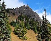
Steeple Rock seen from Obstruction Point Road

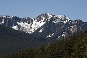
Steeple Rock seen from southeast
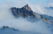
Steeple Rock in clouds
North aspect from Hurricane Ridge Road


External links[]
- "Olympic National Park". National Park Service.
- Olympic Mountains
- Mountains of Clallam County, Washington
- Landforms of Olympic National Park
- North American 1000 m summits