Stephenville Crossing
Stephenville Crossing | |
|---|---|
Town | |
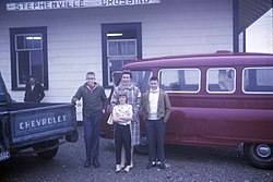 Stephenville Crossing railway station in 1965. | |
| Nickname(s): 'crossing' 'xing' or 'zing' | |
 Stephenville Crossing Location of Stephenville Crossing in Newfoundland | |
| Coordinates: 48°31′N 58°25′W / 48.517°N 58.417°W | |
| Country | |
| Province | |
| Government | |
| • Mayor | Lisa Lucas |
| Area | |
| • Total | 80.8 km2 (31.20 sq mi) |
| Population (2016)[1] | |
| • Total | 1,719 |
| • Density | 55.1/km2 (143/sq mi) |
| Time zone | UTC-3:30 (Newfoundland Time) |
| • Summer (DST) | UTC-2:30 (Newfoundland Daylight) |
| Area code(s) | 709 |
| Highways | |
| Website | http://www.thetownofstephenvillecrossing.com/ |

Stephenville Crossing (2016 population: 1,719[1]) is a Canadian town in the province of Newfoundland and Labrador on the island of Newfoundland. The town is located at the easternmost limit of Bay St. George.[2]
History[]
The settlement derives its name from the Newfoundland Railway, which ran through the community on its way from Port aux Basques to Corner Brook.
The Hanson Memorial Highway was constructed by the United States Army Air Forces (USAAF) to link the railway line at Stephenville Crossing with Harmon Field, which was under construction on the other side of a hill to the north, in Stephenville. Later, the USAAF built its own railway line from Stephenville Crossing to Stephenville.
Since the air base was constructed, Stephenville Crossing has functioned more or less as a suburb of Stephenville, but most locals understand the difference between them since there is a ten-minute car drive between both towns.
The 1988 abandonment of the railway in Newfoundland by CN resulted in the last train running through Stephenville Crossing to St. George's (return) on June 6, 1990.
Facilities[]
Stephenville Crossing, in addition to the usual residential and commercial premises such as a gas station, two pharmacies, two building supplies stores, a convenience store, a volunteer fire department, a hair salon, and a grocery store, also has a clinic with a family doctor and a nurse practitioner. There is a search and rescue building located near Main Street. The Barachois Search and Rescue is active in assisting authorities in water rescues and assisting with finding missing persons. It is also active within the community. It is regularly seen doing training exercises and working with the local children by teaching them vital skills.
There is also a government-ran long-term care centre located in Stephenville Crossing. The Bay St.George Long-Term Care Centre opened in 1976 (expanded in the 1980s), with 114 beds offering complete and total care to residents living with diminished capabilities.[3]
Education[]
St. Michael's Elementary School is a K-8 school off West Street that educates around 150 pupils. Facilities include a science lab, an art room, a music room, a gymnasium, and a cafeteria. It was officially opened in December 1976.
References[]
- ^ Jump up to: a b c "Census Profile". 2016 Census. Statistics Canada.
- ^ "Stephenville Crossing". Encyclopedia of Newfoundland and Labrador, vol.5, p.304-305.
- ^ http://westernhealth.nl.ca/home/locations/locations-2/bay-st-george-long-term-care-centre/
Coordinates: 48°31′N 58°25′W / 48.517°N 58.417°W
| Authority control |
|
|---|
- Designated places in Newfoundland and Labrador
- Towns in Newfoundland and Labrador