Steventon Island
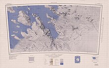
Steventon Island (77°15′S 148°15′W / 77.250°S 148.250°WCoordinates: 77°15′S 148°15′W / 77.250°S 148.250°W) is a broad ice-covered island about 39 km (24 mi) long off of Antarctica, lying west of Court Ridge in the Sulzberger Ice Shelf. It is 45 km (28 mi) long and 27 km (16.8 mi) wide, and covers an area of around 780 km2 (301 sq mi). It was mapped from surveys by the United States Geological Survey (USGS) and U.S. Navy air photos (1959–65), and named by the Advisory Committee on Antarctic Names (US-ACAN) for Richard F. Steventon, USN, Petty Officer in charge of Eights Station, 1963.
 WikiMiniAtlas
![]() This article incorporates public domain material from the United States Geological Survey document: "Steventon Island". (content from the Geographic Names Information System)
This article incorporates public domain material from the United States Geological Survey document: "Steventon Island". (content from the Geographic Names Information System) ![]()
This Marie Byrd Land location article is a stub. You can help Wikipedia by . |
- Islands of Marie Byrd Land
- Marie Byrd Land geography stubs