Stożek Wielki
| Stożek Wielki | |
|---|---|
 Stożek Wielki | |
| Highest point | |
| Elevation | 978 m (3,209 ft) |
| Coordinates | 49°36′20″N 18°49′23″E / 49.605556°N 18.823056°ECoordinates: 49°36′20″N 18°49′23″E / 49.605556°N 18.823056°E |
| Geography | |
 Stożek Wielki Location of Stożek Wielki in Poland, on the Czech border | |
| Location | Poland / Czech Republic |
| Parent range | Silesian Beskids |
| Climbing | |
| Easiest route | Hike |

Stożek Wielki (Czech: Velký Stožek) (literally "big cone") is a mountain on the border of Poland and the Czech Republic, in the Silesian Beskids mountain range. It reaches a height of 978 meters.
The border can be crossed on the top, which is in easy range of the town of Wisła. It has a characteristic conical shape and on its slopes grow beech and coniferous trees.
The mountain hut was built on the mountain from the initiative of Polskie Towarzystwo Turystyczne "Beskid" (Polish Touristic Society "Beskid"). It was opened on 9 July 1922.[1] The main initiators of the construction were PTT activists and Jan Galicz.
Stożek Wielki can be accessed by hiking trails from the nearby municipalities from both sides of the border. There is also a ski resort on the mountain, where skiers can reach using the chairlift.
Through a number of hiking routes it is possible to reach other summits such as , Czantoria Wielka, and towns, down into Wisła, Wisła-Głębce, Istebna, Jaworzynka and Jablunkov (Jabłonków).
The so-called Main Trail of the Beskids (Polish: Główny Szlak Beskidzki), the major hiking trail in the region, also crosses the top.
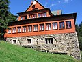
Mountain hut on Stożek

See also[]
Footnotes[]
- ^ Cicha 2007, 111.
References[]
- Cicha, Irena (2007). Beskidzkie gronie nad Olzą i Wisłą. Czeski Cieszyn: Vydavatelství Regio. pp. 106–143. ISBN 978-80-254-0261-0.
- Marciniuk, Krzysztof (7 September 2007). "Pierwsze polskie w Beskidach". . p. 10.
| Wikimedia Commons has media related to Stożek Wielki. |
- Silesian Beskids
- Mountains of Poland
- Mountains and hills of the Czech Republic
- Czech Republic–Poland border
- International mountains of Europe
- Mountains under 1000 metres