Stoke St Michael
| Stoke St Michael | |
|---|---|
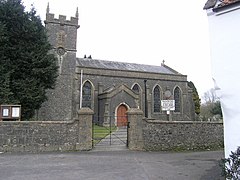 Church of St Michael | |
 Stoke St Michael Location within Somerset | |
| Population | 926 (2011)[1] |
| OS grid reference | ST665465 |
| District | |
| Shire county | |
| Region | |
| Country | England |
| Sovereign state | United Kingdom |
| Post town | RADSTOCK |
| Postcode district | BA3 |
| Dialling code | 01749 |
| Police | Avon and Somerset |
| Fire | Devon and Somerset |
| Ambulance | South Western |
| UK Parliament | |

Stoke St Michael is a village and civil parish on the Mendip Hills 4 miles (6.4 km) north east of Shepton Mallet, and 8 miles (12.9 km) west of Frome, in the Mendip district of Somerset, England.
History[]
Since the 14th century the village has also been known as Stoke Lane, although the origin of the alternative name is unclear, but may be connected to John de Lison who gave lands in the village to Glastonbury Abbey in 1253.[2] The parish of Stoke Lane was part of the Whitstone Hundred.[3]
The village became a centre for cloth manufacture with fulling mills being established on the River Frome to the north of the village. Henry Fussell established paper mills in 1803, and his family, who came from the village, including James Fussell established their iron works and edge-tool business in Mells.[2]
The Knatchbull Arms was built in the late 17th century,[4] and is named after the Knatchbulls of Babington who held the manor in the late 18th century.[2]
The manor house on Tower Hill, which was previously known as the old vicarage, was built around 1700.[5]
Governance[]
The parish council has responsibility for local issues, including setting an annual precept (local rate) to cover the council’s operating costs and producing annual accounts for public scrutiny. The parish council evaluates local planning applications and works with the local police, district council officers, and neighbourhood watch groups on matters of crime, security, and traffic. The parish council's role also includes initiating projects for the maintenance and repair of parish facilities, as well as consulting with the district council on the maintenance, repair, and improvement of highways, drainage, footpaths, public transport, and street cleaning. Conservation matters (including trees and listed buildings) and environmental issues are also the responsibility of the council.
The village falls within the Non-metropolitan district of Mendip, which was formed on 1 April 1974 under the Local Government Act 1972, having previously been part of Shepton Mallet Rural District,[6] which is responsible for local planning and building control, local roads, council housing, environmental health, markets and fairs, refuse collection and recycling, cemeteries and crematoria, leisure services, parks, and tourism.
Somerset County Council is responsible for running the largest and most expensive local services such as education, social services, libraries, main roads, public transport, policing and fire services, trading standards, waste disposal and strategic planning.
It is also part of the Somerton and Frome county constituency represented in the House of Commons of the Parliament of the United Kingdom. It elects one Member of Parliament (MP) by the first past the post system of election.
Geography[]
Several significant caves of the Mendip Hills are close to the village including Stoke Lane Slocker, many falling within the St. Dunstan's Well Catchment and those at the disused Fairy Cave Quarry.
Moon's Hill Quarry is a basalt quarry.
Cook's Wood Quarry is a geological Site of Special Scientific Interest and Geological Conservation Review Site. The main exposures are cut in very steeply-dipping Carboniferous Limestone. This was the original locality for the type section of the proposed ‘Cookswoodian Stage’. 9 species of Bat, Dormice and 4 species of Newts including the rare Great Crested Newt reside in Cooks Wood Quarry.[7]
Edford Woods and Meadows is a biological Site of Special Scientific Interest, which is important for the occurrence of a wide range of types of semi-natural ancient woodland and for unimproved meadows and pastures of a type which is now uncommon in Britain.[8]
Religi[]
The Church of St Michael has a western tower of c. 1400, the remainder being built in 1838 by Jesse Gane. It is a Grade II* listed building.[9] The church was a chapelry of Doulting.[2] The former non-conformist chapel on Stoke Hill is now a private residence.
References[]
- ^ "Stoke St Michael Parish". Neighbourhood Statistics. Office for National Statistics. Retrieved 1 January 2014.
- ^ Jump up to: a b c d Bush, Robin (1994). Somerset: the Complete Guide. Dovecote Press. p. 197. ISBN 1-874336-26-1.
- ^ "Somerset Hundreds". GENUKI. Retrieved 22 October 2011.
- ^ Historic England. "Knatchbull Arms (1058336)". National Heritage List for England. Retrieved 7 February 2009.
- ^ Historic England. "Manor House (1345263)". National Heritage List for England. Retrieved 7 February 2009.
- ^ "Shepton Mallet RD". A vision of Britain Through Time. University of Portsmouth. Retrieved 4 January 2014.
- ^ English Nature citation sheet for the site Archived 24 May 2011 at the Wayback Machine . Retrieved 7 August 2006.
- ^ "Edford Woods and Meadows" (PDF). English Nature. Archived from the original (PDF) on 13 October 2006. Retrieved 20 July 2006.
- ^ Historic England. "Church of St Michael (1173964)". National Heritage List for England. Retrieved 25 November 2006.
External links[]
| Wikimedia Commons has media related to Stoke St Michael. |

| show Authority control |
|---|
- Villages in Mendip District
- Civil parishes in Somerset