Strathclyde
| Strathclyde Srath Chluaidh Ystrad Clud/Alclud | |
|---|---|
| Former Region | |
 | |
| Population | |
| c. 2.25 million | |
| History | |
| • Origin | Local Government (Scotland) Act 1973 |
| • Created | 15 May 1975 |
| • Abolished | 31 March 1996 |
| • Succeeded by | Argyll and Bute East Ayrshire East Dunbartonshire East Renfrewshire Glasgow City Council Inverclyde North Ayrshire North Lanarkshire Renfrewshire South Ayrshire South Lanarkshire West Dunbartonshire |
| Government | Strathclyde Regional Council |
| • Type | Regional Council |
Strathclyde (Srath Chluaidh [s̪t̪ɾa ˈxl̪ˠɯi] in Gaelic, meaning "strath (valley) of the River Clyde") was one of nine former local government regions of Scotland created in 1975 by the Local Government (Scotland) Act 1973 and abolished in 1996 by the Local Government etc. (Scotland) Act 1994. The Strathclyde region had 19 districts. The region was named after the medieval Kingdom of Strathclyde but covered a broader geographic area than its namesake.
Functions[]
The area was on the west coast of Scotland and stretched from the Highlands in the north to the Southern Uplands in the south. As a local government region, its population, in excess of 2.5 million, was by far the largest of the regions and contained half of the nation's total.[1] The Region was responsible for education (from nursery to colleges); social work; police; fire; sewage; strategic planning; roads; transport – and, therefore, employed almost 100,000 public servants (almost half were teachers, lecturers and others in the education service).[2][3]
The regional administrative headquarters was in the city of Glasgow, and politics were by and large dominated by the Labour Party. The first regional council convener was the Reverend Geoff Shaw, who died in 1978. It was largely due to his leadership that the Region forged its innovative strategy on multiple deprivation, which remained its central commitment to the end of the Region's life through "Social Strategy for the Eighties" (1982) and "SS for the 90s".[4]
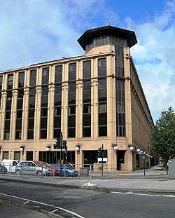
Having lain empty for some years,[5] the Strathclyde Regional Council headquarters' debating chambers were used for a short period in 2000 by the Scottish Parliament, with its new permanent home at Holyrood under construction and the temporary buildings in Edinburgh booked out.[6] The Strathclyde HQ buildings were eventually demolished in the 2010s.[7]
Emergency services[]
Until April 2013, the area was also used as a police force area, covered by Strathclyde Police, and a fire service area, covered by Strathclyde Fire and Rescue Service. Both have now been replaced by single services (Police Scotland and Scottish Fire and Rescue Service).
Transport[]
The name is still in use as a transport area, covered by Strathclyde Partnership for Transport. The area covered by SPT however is smaller than the region, as most of Argyll and Bute lies outside its remit.
Boundaries[]
The region was formed from the county of the City of Glasgow, the counties of Ayr, Bute, Dunbarton, Lanark, and Renfrew, and parts of the counties of Argyll (all except the district of Ardnamurchan and the electoral divisions of Ballachulish and Kinlochleven), and the county of Stirling (the burgh of Kilsyth, Western No. 3 district, the electoral division of Kilsyth West, and the polling district of Kilsyth East (Banton)).[8][9][10]
Since 1996 the area of the region has been divided between 12 council areas: Argyll and Bute, East Ayrshire, East Dunbartonshire, East Renfrewshire, Glasgow City (created as City of Glasgow), Inverclyde, North Ayrshire, North Lanarkshire, Renfrewshire, South Ayrshire, South Lanarkshire, and West Dunbartonshire (created as Dumbarton and Clydebank), all created to be entirely within the area of the region.
Sub-regions and districts[]
Except for Argyll and Bute and the City of Glasgow, the 19 districts were grouped to form 'sub-regions' or 'divisions', each named after a historic county. The Argyll and Bute district and the City of Glasgow district were sub-regions in their own right, and Argyll and Bute was named after two counties.
| Sub-region | District or districts[11] | Composition in terms of counties, burghs, and other areas specified by the 1973 Act |
|---|---|---|
| Argyll and Bute | Argyll and Bute | In county of Argyll: burghs of Campbeltown, Dunoon, Inveraray, Lochgilphead, Oban, and Tobermory; and districts of Cowal, Islay, Jura and Colonsay, Kintyre, Mid Argyll, Mull, North Lorn except the electoral divisions of Ballachulish and Kinlochleven, South Lorn, and Tiree and Coll
In county of Bute: burgh of Rothesay; and district of Bute |
| Ayr | Cumnock and Doon Valley | In county of Ayr: burgh of Cumnock and Holmhead; and districts of Cumnock and Dalmellington except that part of parish of Ayr within this district and polling district of Coylton |
| Cunninghame | In county of Ayr: burghs of Ardrossan, Irvine, Kilwinning, Largs, Saltcoats, and Stevenston; districts of Irvine, Kilbirnie, and West Kilbride, and those parts of Irvine New Town within districts of Ayr and Kilmarnock
In county of Bute: burgh of Millport; and districts of Arran, and Cumbrae | |
| Kilmarnock and Loudoun | In county of Ayr: burghs of Darvel, Galston, Kilmarnock, Newmilns and Greenholm, and Stewarton; and district of Kilmarnock except that part of Irvine New Town within this district | |
| Kyle and Carrick | In county of Ayr: burghs of Ayr, Girvan, Maybole, Prestwick, and Troon; districts of Ayr except that part of Irvine New Town within this district, Girvan, and Maybole, that part of parish of Ayr within the district of Dalmellington; and polling district of Coylton | |
| Dunbarton | Bearsden and Milngavie | In county of Dunbarton: burghs of Bearsden and Milngavie; and that part of electoral division of Hardgate within parish of New Kilpatrick |
| Clydebank | In county of Dunbarton: burgh of Clydebank; and district of Old Kilpatrick except electoral divisions of Bowling and Dunbarton and that part of electoral division of Hardgate within parish of New Kilpatrick | |
| Cumbernauld and Kilsyth | In county of Dunbarton: burgh of Cumbernauld; electoral division of Croy and Dullatur and those parts of electoral divisions of Twechar and Waterside within Cumbernauld New Town
In county of Stirling: burgh of Kilsyth; electoral division of Kilsyth West; and polling district of Kilsyth East (Banton) | |
| Dumbarton | In county of Dunbarton: burghs of Dumbarton, Cove and Kilcreggan, and Helensburgh; districts of Helensburgh, and Vale of Leven; and electoral divisions of Bowling and Dunbarton | |
| Strathkelvin | In county of Dunbarton: burgh of Kirkintilloch; and those parts of the electoral divisions of Twechar and Waterside outwith Cumbernauld New Town
In county of Lanark: burgh of Bishopbriggs; and electoral divisions of Chryston and Stepps | |
| Glasgow | City of Glasgow | County of City of Glasgow
In county of Lanark: burgh of Rutherglen; and parts of the Eighth district (electoral divisions of Bankhead, Cambuslang Central, Cambuslang North, Hallside, and Rutherglen, and those parts of Cambuslang South and Carmunnock electoral divisions outwith East Kilbride New Town) and the Ninth district (electoral divisions of Baillieston, Garrowhill, Mount Vernon and Carmyle, and Springboig) |
| Lanark | Clydesdale | In county of Lanark: burghs of Biggar, and Lanark; and First, Second, and Third districts |
| East Kilbride | In county of Lanark: burgh of East Kilbride; in Fourth district, electoral division of Avondale and, in Eighth district, those parts of High Blantyre, Cambuslang South, and Carmunnock electoral divisions within East Kilbride New Town | |
| Hamilton | In county of Lanark: burgh of Hamilton; Fourth district except electoral division of Avondale, in the Sixth district, electoral divisions of Bothwell and Uddingston South, and Uddingston North and, in Eighth district, electoral divisions of Blantyre, and Stonefield, and that part of High Blantyre electoral division outwith East Kilbride New Town. | |
| Monklands | In county of Lanark: burghs of Airdrie, and Coatbridge; Ninth district except electoral divisions of Baillieston, Chryston, Garrowhill, Mount Vernon and Carmyle, Springboig, and Stepps and, in Seventh district, electoral division of Shottskirk | |
| Motherwell | In county of Lanark: burgh of Motherwell and Wishaw; Sixth district except electoral divisions of Bothwell and Uddingston South, and Uddingston North and Seventh district except electoral division of Shottskirk | |
| Renfrew | Eastwood | In county of Renfrew: First district |
| Renfrew | In county of Renfrew: burghs of Barrhead, Johnstone, Paisley, and Renfrew; and Second, Third, and Fourth districts | |
| Inverclyde | In county of Renfrew: burghs of Gourock, Greenock, Port Glasgow; and Fifth district |
Council areas[]
| Council area | Composition in terms of districts and other areas specified by the 1994 Act |
|---|---|
| Argyll and Bute | Argyll and Bute district and part of Dumbarton district (Helensburgh (7) regional electoral division and part of Vale of Leven (8) regional electoral division) |
| East Ayrshire | Kilmarnock and Loudoun and Cumnock and Doon Valley districts |
| East Dunbartonshire | Bearsden and Milngavie district and part of Strathkelvin district (Kirkintilloch (43), Strathkelvin North (44) and Bishopbriggs (45) regional electoral divisions and South Lenzie/Waterside district ward) |
| East Renfrewshire | Eastwood district and part of Renfrew district (Barrhead (79) regional electoral division) |
| Glasgow City (created as City of Glasgow) | City of Glasgow district except Rutherglen/Fernhill (37) and Cambuslang/Halfway (38) regional electoral divisions and part of King's Park/Toryglen (35) regional electoral division |
| Inverclyde | Inverclyde district |
| North Ayrshire | Cunninghame district |
| North Lanarkshire | Cumbernauld and Kilsyth, Monklands, Motherwell districts and part of Strathkelvin district (Chryston (46) regional electoral division except South Lenzie/Waterside district ward) |
| Renfrewshire | Renfrew district except Barrhead (79) regional electoral division |
| South Ayrshire | Kyle and Carrick district |
| South Lanarkshire | Clydesdale, East Kilbride, and Hamilton districts and part of City of Glasgow district (Rutherglen/Fernhill (37) and Cambuslang/Halfway (38) regional electoral divisions and part of King's Park/Toryglen (35) regional electoral division) |
| West Dunbartonshire (created as Dumbarton and Clydebank) | Clydebank and part of Dumbarton (Dumbarton (6) regional electoral division and part of Vale of Leven (8) regional electoral division) |
Electoral history[]
| Election | Control | Administration | |
|---|---|---|---|
| 1974 | Labour | ||
| 1978 | |||
| 1982 | |||
| 1986 | |||
| 1990 | |||
| 1994 | |||
District result maps[]

1982 results map

1986 results map

1990 results map
1994 results map


Name[]
The region was named after the ancient British or Brythonic Damnonii Kingdom of Strathclyde. The kingdom broadly covered the northern end of the region, except an area now covered by the Scottish Argyll and Bute council area and the Isle of Arran, which is now within the Scottish North Ayrshire council area, plus the Scottish Dumfries and Galloway council area and part of the English county of Cumbria.
Council leadership[]
| Name | Entered office | Left office | Political party | |
|---|---|---|---|---|
| Geoff Shaw | 1975 | 1978 | Labour | |
| Charles O'Halloran | 1978 | 1982 | Labour | |
| James Burns | 1982 | 1986 | Labour | |
| James Jennings | 1986 | 1990 | Labour | |
| David Sanderson | 1990 | 1994 | Labour | |
| William Perry | 1994 | 1996 | Labour | |
| Name | Entered office | Left office | Political party | |
|---|---|---|---|---|
| Dick Stewart | 1975 | 1986 | Labour | |
| Charles Gray | 1986 | 1992 | Labour | |
| Robert Gould | 1992 | 1996 | Labour | |
See also[]
- Glasgow (European Parliament constituency)
- Strathclyde East (European Parliament constituency)
- Strathclyde West (European Parliament constituency)
- Strathclyde Park, in Motherwell, created during the era
- University of Strathclyde, in Glasgow
References[]
- ^ Strathclyde, Undiscovered Scotland
- ^ A cry of 'Gerrymander' as Strathclyde is axed, The Independent, 18 July 1993
- ^ Region hands over reins after 21 years, The Herald, 18 March 1996
- ^ "key papers". publicadminreform.
- ^ Clive House (Mitchell Library, Glasgow Collection, Bulletin Photographs, c 1980), The Glasgow Story
- ^ "Glasgow's miles better for parliament". BBC News. 13 January 2000. Retrieved 26 February 2020.
- ^ Final stage of demolition of Strathclyde Regional Council HQ begins, Evening Times, 10 March 2015
- ^ "New Local Government areas". Hansard. 22 October 1973. Retrieved 4 November 2018.
- ^ Irene Maver. "Modern Times: 1950s to The Present Day > Neighbourhoods". The Glasgow Story. Retrieved 4 November 2018.
- ^ "Scotland's Landscape: City of Glasgow". BBC. Retrieved 4 November 2018.
- ^ Various district names are not those given in the 1973 Act, but were chosen, under the same act, by the district councils themselves soon after their creation
External links[]
 Media related to Strathclyde at Wikimedia Commons
| hide Local government areas of Scotland, in use 1973 to 1996 | ||
|---|---|---|
| Borders |
|  |
| Central Region | ||
| Dumfries and Galloway |
| |
| Fife | ||
| Grampian |
| |
| Highland |
| |
| Lothian |
| |
| Strathclyde |
| |
| Tayside |
| |
| Island areas1 | ||
| Authority control |
|---|

- Regions of Scotland
- 1996 disestablishments in Scotland
- 1975 establishments in Scotland