Stretham
| Stretham | |
|---|---|
 Stretham Windmill | |
 Stretham Location within Cambridgeshire | |
| Area | 6.27 sq mi (16.2 km2) [1] |
| Population | 1,831 [2] |
| • Density | 292/sq mi (113/km2) |
| OS grid reference | TL513747 |
| • London | 64 mi (103 km) S |
| Civil parish |
|
| District | |
| Shire county | |
| Region | |
| Country | England |
| Sovereign state | United Kingdom |
| Post town | ELY |
| Postcode district | CB6 |
| Dialling code | 01353 |
| Police | Cambridgeshire |
| Fire | Cambridgeshire |
| Ambulance | East of England |
| UK Parliament | |
| Website | www |

Stretham /ˈstrɛtəm/[note 1] is a village and civil parish 4 miles (6 km) south-south-west of Ely in Cambridgeshire, England, about 74 miles (119 km) by road from London. Its main attraction is Stretham Old Engine, a steam-powered pump used to drain the fens. The pump is still in use today although converted to electric power. It has open days throughout the year.
History[]

A Bronze Age hoard consisting of gold jewellery including a torque, bracelet, six ribbed-rings as well as a bronze rapier was discovered in Granta Fen near Stretham in 1850. Dating to between 1300 and 1000 BC, the torque is in the Hunt Museum in Limerick while the remainder of the treasure is in the British Museum.[3]

Stretham means homestead[6] or village[7] on the road (possibly Roman); Latin strata for paved road or old English ystrad for road plus old English ham for village.[8] The route of the Roman road from Cambridge is uncertain beyond Waterbeach.[9]
Brythnoth (the first Abbot of the Benedictine monastery at Ely Abbey) and Æthelwold (Bishop of Winchester) purchased the Stretham estate, among others including Haddenham, Wilburton and Witchford, after the restoration of the monastery in 970 with the encouragement of King Edgar.[10][11] The Domesday Book records the village as "Stradham: Abbot of Ely. Fisheries."[12]
Several fires have occurred in the village. In 1696 damage assessed at £2,170 was caused and a general collection was made. A more serious fire broke out on May Day 1844 in the blacksmith's shop. The whole of 'Bell Street' was destroyed and £20,000 worth of damage was caused. In the autumn of 1850 four fires, the work of incendiaries, occurred at Stretham in as many weeks, 'by which property to a large amount was sacrificed.' A detective from London made investigations, but the culprit was not discovered.[13]
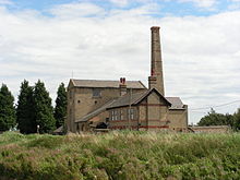
The Stretham steam pumping engine, built in 1831 by Butterley Company, was one of the largest beam engines in the Fens; at 15 rpm it generated 105 horsepower lifting 30 tons of water per revolution, or 450 tons per minute.[14]
The village is the site of an observation post of the Royal Observer Corps, in use during the Cold War from 1962 to 1968. The post is situated near the windmill, which also served as an aircraft post from 1936.[15]
The river floods that began in mid-March 1947 affected over 1,000 square miles (2,600 km2) of England, impacting thirty counties. It was the worst UK flooding event for over 200 years.[16] The winter of 1946–1947 had been very severe, with mean average temperatures 4 °C (7 °F) below normal, for that time of year.[17] Snow had been falling continuously since 23 January, with drifts up to 23 feet (7.0 m) deep in places. As the thaw began in mid-March, the warmer weather brought heavy rains. The rain running off the frozen ground, combined with the thaw, overwhelmed multiple rivers in England and eastern Wales, which flooded. The pumping station at Chear Fen, near Stretham, ran only for a short time during the floods, when one of the boilers broke down completely and the other boiler could not raise pressure. In 1950, a new pumping station was opened.[18]
The skeletal remains of a 130-million-year-old Upper Jurassic Pliosaur were discovered in a 5 feet (1.5 m) deep Kimmeridge Clay pit in the village in 1952 by workers of the Great Ouse River Board.[19] These carnivores could reach up to 65 feet (20 m) in length and pliosaur teeth are a common fossil; full skeletons are however rare.[20] This particular 23 feet (7 m) example was named Stretosaurus macromerus in honour of the village where it was found.[21][22]
Governance[]
The ward of Stretham comprises three civil parishes, Stretham,[23] Thetford,[24] and Wilburton,[25] each of which has an elected council. Parish council services include bus shelters, cemeteries, shared equity housing, local planning consultation, play areas, village halls, and war memorials. Parish council meetings are held in the village hall situated in each civil parish.[26]
The area formed part of Ely Rural District from 1894 until 1974.[27] East Cambridgeshire District Council (ECDC) was formed in 1974 with administration buildings in Ely. The district council collects council tax, provides services such as building regulations and local planning, leisure and tourism, handles issues strategic to the district, and many other services. Cambridgeshire County Council, which has administration buildings in Cambridge, provides county-wide services such as major road infrastructure, fire and rescue, libraries and heritage, and strategic planning.[26] A mobile library visits the village every fortnight.[28]
The parish is represented in the House of Commons of the Parliament of the United Kingdom as part of South East Cambridgeshire. It elects one Member of Parliament (MP) by the first past the post system of election.
Geography[]
| show Places adjacent to Stretham |
|---|
Geology[]
The village is on an east–west running boulder clay (middle-Pleistocene till) ridge sitting on a belt of mainly Jurassic Kimmerigian clays running south-west from The Wash. To the east is a north–south running belt of geologically more recent Upper-Cretaceous Lower Greensand capped by Lower-Cretaceous Gault Clay; the whole area is surrounded by even more recent fen deposits. A rich layer of phosphate fossils, known locally as coprolite and mined for its fertiliser value, is to be found at the junction of Lower Greensand and Gault Clay. Further east is a north-east—south-west running belt of Cretaceous chalk. To the west, again running north-east—south-west, is a scarp belt of middle-Jurassic sedimentary rocks including limestone and sandstone.[29][30]
The flat fenland countryside around the village, typical for this part of the region, lies about 16 feet (5 m) above sea-level. The highest point in the village is 53 feet (16 m) above sea-level and the highest point in the area is 85 feet (26 m) at Ely, three-mile (6 km) north-north-east.[31] In contrast, the highest point in Cambridgeshire, 479 feet (146 m) above sea-level, is at Great Chishill, 23 miles (37 km) almost due south. Holme at nine feet (2.75 m) below sea-level is East Cambridgeshire's (and the United Kingdom's) lowest point, and is 23 miles (37 km) north-west.[32]
Boundaries[]
The eastern border is formed by the River Cam. The River Great Ouse forms the south-west border then, at the Stretham Ferry Bridge, cuts through the south-eastern corner joining the River Cam at the north-east corner of the village. The A10 road crosses the River Great Ouse at close to the Stretham Ferry Bridge at the southern border of the village then, running firstly due north, cuts the village in half running north-east on towards Little Thetford then Ely. Newmarket road, in this area the west–east running A1123 from Huntingdon, joins the village coming from the west out of Wilburton through the village crossing the River Great Ouse at Gravel Farm then on towards Wicken.
Climate[]
The average annual rainfall of 24 inches (600 mm) makes Cambridgeshire one of the driest counties in the British Isles. Protected from the cool onshore coastal breezes east of the region, Cambridgeshire is warm in summer and cold and frosty in winter.[33] Regional weather forecasting and historical summaries are available from the UK Met Office.[34] The nearest Met Office weather station is Cambridge.[35]
| hideClimate data for Cambridge (1971–2000 averages) | |||||||||||||
|---|---|---|---|---|---|---|---|---|---|---|---|---|---|
| Month | Jan | Feb | Mar | Apr | May | Jun | Jul | Aug | Sep | Oct | Nov | Dec | Year |
| Average high °C (°F) | 7.0 (44.6) |
7.4 (45.3) |
10.2 (50.4) |
12.6 (54.7) |
16.5 (61.7) |
19.4 (66.9) |
22.2 (72.0) |
22.3 (72.1) |
18.9 (66.0) |
14.6 (58.3) |
9.9 (49.8) |
7.8 (46.0) |
14.1 (57.4) |
| Average low °C (°F) | 1.3 (34.3) |
1.1 (34.0) |
2.9 (37.2) |
4.0 (39.2) |
6.7 (44.1) |
9.8 (49.6) |
12.0 (53.6) |
11.9 (53.4) |
10.1 (50.2) |
7.1 (44.8) |
3.7 (38.7) |
2.3 (36.1) |
6.1 (43.0) |
| Average rainfall mm (inches) | 45.0 (1.77) |
32.7 (1.29) |
41.5 (1.63) |
43.1 (1.70) |
44.5 (1.75) |
53.8 (2.12) |
38.2 (1.50) |
48.8 (1.92) |
51.0 (2.01) |
53.8 (2.12) |
51.1 (2.01) |
50.0 (1.97) |
553.5 (21.79) |
| Source: Met Office | |||||||||||||
Demography[]
Stretham is in output area classification zones (CGM) one through five; mainly classified as type three-C, accessible countryside, though about one third of the area is classed as three-A, village life.[36] In both these classifications, most residents work from home employed in agriculture of fishing. The areas in this classification are less densely populated than other areas of the country. The usually detached households generally have two or more cars. Varied ethnic backgrounds are less likely in such areas.[37]
| Historical population of Stretham | |||||||||||
| Year | 1801 | 1811 | 1821 | 1831 | 1841 | 1851 | 1861 | 1871 | 1881 | 1891 | 1901 |
|---|---|---|---|---|---|---|---|---|---|---|---|
| Population | 636 | 697 | 875 | 916 | 1107 | 1231 | 1156 | 1145 | 1076 | 1055 | 1000 |
| Year | 1911 | 1921 | 1931 | 1941 | 1951 | 1961 | 1971 | 1981 | 1991 | 2001 | 2011 |
| Population | 961 | 897 | 993 | [note 2] | 970 | 1009 | 990 | 1197 | 1439 | 1685 | 1831 |
Notable buildings[]
To the east of the 12th century site of St James' Church[38] stands an early 15th century cross[39] "...the most perfect surviving example in the country.";[40] it was restored in 1910.[41] Parts of St James's Church are 14th century though it was heavily restored in the 19th century. Monuments include a tomb lid with an inscription which refers to Nicholas de Kyngestone, rector late 13th century; a brass to Joan Swan, 1497; a black marble slab for Anne Brunsell, 1667, wife of a rector, and sister of Sir Christopher Wren.[42] The church is part of the Ely team ministry along with the nearby St George's Church, Little Thetford.[43]
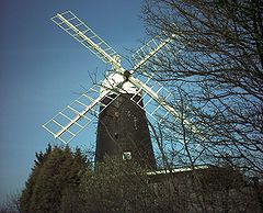
The Stretham Windmill (now a private home) at the top of High Street where it meets the A10 is a Grade II Listed Building (listed in 1988). It dates from 1881 and consists of four storeys of tarred brick and a metal ogee cap and fantail.[44] The Royal Observer Corps were based adjacent to it from 1962 till 1968 and used the windmill itself as an aircraft observation post from 1936.[45][46] The windmill is a notable landmark on the A10 road.
The Red Lion public house is a former coaching inn[47] which had been operating since at least 1763 when agreement was reached to build a bridge across the River Great Ouse for the Ely-Cambridge turnpike at Stretham Ferry.[48] The original bridge was replaced in 1925, and the road was realigned in 1976 so this bridge is no longer used by traffic between Ely and Cambridge.
The village store includes a post office.[49]
Transport[]
The village was once served by a railway station on the Ely and St Ives Railway. The line between Ely station and Sutton was opened 16 April 1866 under Great Eastern Railway (GER) operation. On 10 May 1878 the line was completed when the Needingworth junction, on the St Ives to March line, was linked to the Ely–St Ives branch. Although passenger traffic was always poor; the line closed to passengers 22 February 1931, seasonal freight traffic of sugar-beet and fruit kept the line going until it finally closed 5 October 1964.[50] The new bridge for the A10 at Stretham Ferry was constructed in 1975 diverting the road over the River Great Ouse at Chear Lode.[51]
Education[]

Stretham Community Primary School serves the community.
Notable people[]
- Hervey le Breton (d. 1131), Bishop of Ely.[52]
- Lancelot Ridley (d. 1576),[53] appointed one of the first Six Preachers of Canterbury Cathedral in 1541[54] and a rector of Stretham from 1560, was buried in the parish.[55]
- John Parker (1532/3–1592), Church of England clergyman.[56]
- Mark Ridley (1560–1624), son of Lancelot Ridley, physician who became the personal physician to the Tsar of Russia, was born in Stretham. A 7,203 entry Russian–English dictionary was published by Ridley, and also books on magnetism; he was a friend of William Gilbert.[57]
- Ralph Brownrigg (1592–1659),[58] Bishop of Exeter. Vicar in Stretham and Prebendary of Ely in 1821.[59]
- Henry Hervey Baber (bap. 1775, d. 1869),[60] philologist and Church of England clergyman, rector at St James, Stretham 1827–1869.
- Joseph Glynn (1799–1863), engineer, responsible for the Stretham steam pumping engine and others.[61]
- Philip Freeman (1818–1875), Church of England clergyman and Archdeacon of Exeter.[62] Married youngest daughter of Henry Hervey Baber (above).
- Sir George Harry Smith Willis (1823–1900),[63] British Army general and colonel of the Middlesex Regiment (The Duke of Cambridge's Own). He inherited half of the manorial rights or lordship of Stretham in 1861 in the right of his wife (daughter of G. G. Morgan, the previous owner, who died in 1845).[64][65]
- Jean Adamson M.B.E.(1928– ), writer of Topsy and Tim lives in the village
See also[]
Notes[]
- ^ Locally, the /t/ is a glottal stop: ['str???m] or even ['str??m]
- ^ No census 1941 due to World War II
References[]
- ^ Jump up to: a b "Historic Census Population Figures". Cambridgeshire County Council. 2010. Archived from the original (XLS) on 9 June 2011. Retrieved 25 July 2010.
- ^ Jump up to: a b "Key Figures for 2011 Census: Key Statistics. Area: Stretham (Parish)". ONS. 2013. Retrieved 2 February 2013.
- ^ British Museum Collection
- ^ Historic England. "- Village cross (early 15th century) Grade II* (1126992)". National Heritage List for England. Retrieved 1 August 2010.
- ^ Urban, Sylvanus (1832). The Gentleman's Magazine and Historical Review. p. 108. Retrieved 1 August 2010.
- ^ OED (2010) Homestead: "The place (town, village, etc.) in which one's dwelling is"
- ^ OED (2010) Village: "A collection of dwelling-houses and other buildings, forming a centre of habitation in a country district"
- ^ Mills (1991) Stretham
- ^ "The Roman roads of Britain – map". Archive of www.romans-in-britain.org.uk. Archived from the original on 11 January 2008. Retrieved 17 April 2015.CS1 maint: unfit URL (link)
- ^ Bentham, James (1771). The History and Antiquities of the Conventual and Cathedral Church of Ely, From the Foundation of the Monastery, A.D. 673. To the Year 1771. Cambridge University Press. p. 75.
- ^ Pugh (ed)(1953) p. 152 col 2
- ^ "Cambridgeshire, Stretham". The Domesday Book Online. 1999–2010. Retrieved 26 July 2010.
- ^ "Stretham and Thetford". British History Online. Retrieved 12 March 2015.
- ^ Ashby, Michael F; Jones, David R H (2005). Engineering Materials 1:Case Study 3: fatigue of a cracked component—the safety of the Stretham engine. Elsevier Butterworth-Heinemann. pp. 264–265. ISBN 0-7506-6380-4.
- ^ Osborne (2002) Cambridgeshire Historic Environment Record Royal Observer Corps Post, Stretham
- ^ "U.K. River Floods: 60-Year Retrospective" (PDF). Risk Management Solutions. 2007. Retrieved 30 July 2010.
- ^ "Serious snowfall in the winter of 1947". Severe winters. Met Office. 2010. Archived from the original on 5 June 2011. Retrieved 30 July 2010.
- ^ Petty, Mike (April 2009). "Looking back stories:1950". Cambridgeshire & the fens. Retrieved 30 July 2010.
- ^ "Prehistoric Find at Stretham". The Ely Standard and Cambridgeshire Times. 13 June 1952.
- ^ Wroot, Sarah (2000). Stretham Geology. Cambridgeshire Heritage Associates.
- ^ Tarlo, L B (1959). "Stretosaurus Gen. Nov., A Giant Pliosaur from the Kimmeridge Clay". Palaeontology. 2 (1): 39–55.
- ^ "Plesiosaurus remains discovered in clay pit". Cambridgeshire Historic Environment Record. Retrieved 3 June 2014.
- ^ Office for National Statistics (2001). "Area: Stretham CP (Parish)". 2001 Census. Office for National Statistics. Retrieved 7 June 2010.
- ^ Office for National Statistics (2001). "Area: Thetford CP (Parish)". 2001 Census. Office for National Statistics. Retrieved 7 June 2010.
- ^ Office for National Statistics (2001). "Area: Wilburton CP (Parish)". 2001 Census. Office for National Statistics. Retrieved 7 June 2010.
- ^ Jump up to: a b Leaflet:Councillors, committees & meeting dates. East Cambridgeshire District Council. February 2010.
- ^ A Vision of Britain Administrative unit:Ely RD:Local Government District
- ^ "Mobile libraries: Our service for small communities". Cambridgeshire County Council. 2010. Archived from the original on 22 January 2011. Retrieved 22 June 2010.
- ^ Darby (1940) p. 3 fig. 1
- ^ Geological Survey of Great Britain (Map) (Based on 1st series 1:50000 map part of sheet 143 – 1974 ed.). Ordnance Survey. 1981. § Cambridge, Sheet 188.
- ^ Grid reference TL5123374792
- ^ "UK's lowest spot is getting lower". England: BBC. 29 November 2002. p. 1. Retrieved 28 July 2010.
- ^ Greig (1998) p. 305
- ^ "Forecast:East of England". UK Climate Forecasts. Retrieved 28 July 2010.
- ^ "Historical Data:Regional:Cambridge NIAB". UK Climate Summaries. Archived from the original on 29 June 2011. Retrieved 28 July 2010.
- ^ "Geodmographic tool" (Flash) (Map). Output Area Classification (OAC). Cambridgeshire County Council. 2008. Retrieved 27 July 2010.[permanent dead link]
- ^ "Supergroup 3: Countryside" (PDF). Cambridgeshire Atlas: Output Area Classification (OAC): Notes. Cambridgeshire County Council. 2008. Archived from the original (PDF) on 8 June 2011. Retrieved 27 July 2010.
- ^ Pigot (1875) Cambridgeshire Historic Environment Record Saint James' Church, Stretham (12th century to Modern—1101–2050 AD)
- ^ Rutler (1947) Cambridgeshire Historic Environment Record Village Cross, Stretham (Medieval 1066–1539 AD)
- ^ Pugh (ed)(1953) p. 152 col 1
- ^ Kelly, Lindsay A (1929). Cambridgeshire:Stretham. Kelly's Directories. Retrieved 21 August 2010.
- ^ Pevsner, Nikolaus (1970). The buildings of England: Cambridgeshire (2nd ed.). Penguin Books. p. 462. ISBN 0-14-071010-8.
- ^ Shaw, Tony (n.d.), The Friends of St. George's Church, Leaflet
- ^ "Windmill, Stretham". British Listed Buildings. Retrieved 12 March 2015.
- ^ "Stretham". Online survey of ROC.
- ^ "Cambridgeshire HER". Heritage Gateway. Retrieved 12 March 2015.
- ^ "The Red Lion". redlionstretham.com. Red Lion. Retrieved 10 January 2015.
- ^ "Articles of agreement to construct the dams needed for building Stretham Ferry bridge". National Archives. Retrieved 12 March 2015.
- ^ "Village description". www.strethampc.org.uk. Stretham Parish Council. Retrieved 10 January 2015.
- ^ Oppitz (1989) pp. 58–59
- ^ Petty, Mike (April 2009). "Looking back stories:Cambridgeshire News, Wednesday 27 July 1975". Cambridgeshire & the fens. Retrieved 16 August 2010.
- ^ Owen (2004) ODNB Hervey (subscription required)
- ^ Shaw, William Arthur (1896). . In Lee, Sidney (ed.). Dictionary of National Biography. 48. London: Smith, Elder & Co.
- ^ James Gairdner, James (1908). Lollardy and the Reformation in England: An Historical Survey: Book III The fall of the monasteries. p. 359. ISBN 9781103041756.
- ^ Shaw (2004) ODNB Lancelot Ridley (subscription required)
- ^ Wright (2004) ODNB John Parker (subscription required)
- ^ Stone (2004) ODNB Mark Ridley (subscription required)
- ^ Wolffe (2004) ODNB Ralph Brownrigg (subscription required)
- ^ "A Cambridge Alumni Database". University of Cambridge. Archived from the original on 16 March 2015.
- ^ Harris (2004) ODNB Henry Hervey Baber (subscription required)
- ^ Hills (2004) ODNB Joseph Glynn (subscription required)
- ^ Boase (2004) ODNB Philip Freeman (subscription required)
- ^ Vetch (2004) ODNB Sir George Harry Smith Willis (subscription required)
- ^ "South Witchford Hundred: Stretham and Thetford". British History Online.
- ^ "Stretham – Extract from Imperial Gazetteer". Vision of Britain. 1870.
Bibliography[]
- "Cambridgeshire Historic Environment Record (CHER)". Heritage Gateway. 2006. Retrieved 26 July 2010.
- Mills, A.D. (1991). A dictionary of British place-names. Oxford University press. ISBN 0-19-852758-6.
- Oppitz, Leslie (1989). East Anglia railways remembered. Countryside Books, Newbury, Berkshire. pp. 58–59. ISBN 1-85306-040-2.
- Oxford Dictionary of National Biography (ODNB) (online ed.). Oxford University Press. 2004–2010.(subscription required)
- Oxford English Dictionary (OED) (online ed.). Oxford University Press. 2010.(subscription required)
- T.D. Atkinson; Ethel M. Hampson; E.T. Long; C.A.F. Meekings; Edward Miller; H.B. Wells; G.M.G. Woodgate (1953). Pugh, R.B. (ed.). The Victoria History of the Counties of England: Cambridge and the isle of Ely. IV. Oxford University Press. pp. 151–159.
External links[]
| Wikimedia Commons has media related to Stretham. |
- Official website
- Stretham Feast Pictures 2011
- 2001 Census profile, Stretham parish, East Cambridgeshire
- Historic England. "The Rectory (possibly medieval but mainly late 17th century) Grade II* (1178610)". National Heritage List for England.
- Historic England. "White Lion cottage, formerly White Lion public house (circa 1600) Grade II (1178613)". National Heritage List for England.
- Historic England. "Cottage (17th century origin) Grade II (1178605)". National Heritage List for England.
- Historic England. "Cottage (early 17th century) Grade II (1126991)". National Heritage List for England.
- Historic England. "Barn (mid-17th century) Grade II (1331486)". National Heritage List for England.
- Historic England. "Home Farmhouse (mid-17th century) Grade II (1178572)". National Heritage List for England.
- Historic England. "1,3,5 Plantation Gate (1770) Grade II (1126993)". National Heritage List for England.
- Historic England. "14 Reads Street (18th century origin) Grade II (1126994)". National Heritage List for England.
- Historic England. "Orchard House (circa 1823) Grade II (1178620)". National Heritage List for England.
- Historic England. "Barn (circa 1840) Grade II (1331485)". National Heritage List for England.
- Historic England. "Coach house and granary (1843) Grade II (1127030)". National Heritage List for England.
- Historic England. "Tower windmill now a house (1881) Grade II (1302342)". National Heritage List for England.
- Historic England. "Hylton House (184(3?)) Grade II (1178624)". National Heritage List for England.
- Historic England. "Cottage 1 Pump Lane (late 18th century) Grade II (1178623)". National Heritage List for England.
| show Settlements in East Cambridgeshire |
|---|

- Civil parishes in Cambridgeshire
- East Cambridgeshire District
- Villages in Cambridgeshire