Subang Regency
Subang Regency
Kabupaten Subang | |
|---|---|
Regencies of Indonesia | |
| Other transcription(s) | |
| • Sundanese | ᮊᮘᮥᮕᮒᮦᮔ᮪ ᮞᮥᮘᮀ |
 Coat of arms | |
| Motto(s): Karya Utama Satya Nagara (Prioritizing Works for the Sake of the Country) | |
 Location in West Java | |
 Subang Regency Location in Java Island and Indonesia | |
| Coordinates: 6°34′16″S 107°45′42″E / 6.5711°S 107.7616°ECoordinates: 6°34′16″S 107°45′42″E / 6.5711°S 107.7616°E | |
| Country | Indonesia |
| Province | West Java |
| Formation | 5 April 1948 |
| Legal Basic | Kep. DPRD No. 01/SK/DPRD/1977 |
| Anniversary | 5 April 1948[2] |
| Capital City | Subang |
| Administrative division | 30 Districts 245 Villages 8 Official Villages |
| Government | |
| • Regent | |
| • Vice Regent | |
| • | Rp. 1.032.567.532.000,00 (2013)[1] |
| Area | |
| • Total | 2,051.76 km2 (792.19 sq mi) |
| Highest elevation | 2,084 m (6,837 ft) |
| Lowest elevation | 0 m (0 ft) |
| Population (2020 Census) | |
| • Total | 1,595,320 |
| • Density | 750/km2 (1,900/sq mi) |
| [3] | |
| Demonyms | Subangite Warga Subang (id) Urang Subang (su) |
| Demographic | |
| • Languages | Sundanese, Indonesia, Bahasa Cirebon (specifically in the coastal areas and banks of the Cipunagara river) |
| Time zone | UTC+7 (Time in Indonesia) |
| Postal Codes | 412xx |
| Area code(s) | +62 260 |
| Vehicle registration | T |
| HDI | |
| Website | subang.go.id |


Subang Regency (Sundanese script: ᮊᮘᮥᮕᮒᮦᮔ᮪ ᮞᮥᮘᮀ, Latin: Kabupatén Subang) is a regency (kabupaten) in Tatar Pasundan, West Java province, Indonesia. The Regency is bordered by the Java Sea in the north, Indramayu Regency in the east, Sumedang Regency in the southeast, West Bandung Regency in the south, and Purwakarta Regency and Karawang Regency in the west. It has an area of 2,051.76 km² and its population was 1,465,157 at the 2010 Census and 1,595,320 at the 2020 Census.[4] Its administrative seat is in the town of Subang.
Administrative districts[]
Subang Regency is divided into 30 districts, tabulated below with their areas and their populations at the 2010 Census and 2020 Census.[5]
|
|
Tourism[]
Subang has a variety of artistic and cultural interest.
Attractions[]
In South Subang[]
A number of resorts exist in the Subang area to the north of Bandung. These include the following:
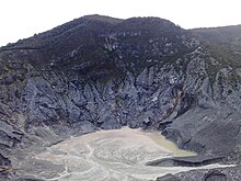
- Mount Tangkuban Perahu
In Central Subang[]
Historical and Religious Tourism[]
- Building
- (en : Big Building)
- Historic Building
The handover of the Republic of Indonesia from the Netherlands to Japan, before independence, 1942. These buildings are in , District.
In North Subang[]
The Culinary[]
- Nanas khas subang / Subang pineapple
- Kerupuk miskin purwadadi / Indonesian Crackers
- Sundanese foods
Toll Road Access[]
| KM | Toll Road | Toll Gate | Destination | |
|---|---|---|---|---|
| 98 | Cikopo-Palimanan Toll Road | Kalijati | Kalijati, Purwadadi, Sukamandi | |
| 110 | Subang | Subang, Pamanukan, Lembang | ||
| 76 | Sadang | Purbaleunyi Toll Road | Sadang | Sadang, Purwakarta, Subang |
| 127 | Pasteur | Pasteur, Lembang |
Patimban Deep Sea Port[]
Patimban Deep Sea Port is under construction seaport at Subang, West Java, as an upgrade from the existing small Patimban Port. It is located about 70 kilometers from the Karawang Industrial Estate and 145 kilometers from the city center of Jakarta, where many Japanese industrial firms, particularly automotive manufacturers operate. The project was initialized in 2017 and predicted to be operated in 2019.[6]
References[]
- ^ "Perpres No. 10 Tahun 2013". 2013-02-04. Retrieved 2013-02-15.
- ^ "Sejarah Kabupaten Subang".
- ^ Badan Pusat Statistik, Jakarta, 2021.
- ^ Badan Pusat Statistik, Jakarta, 2021.
- ^ Badan Pusat Statistik, Jakarta, 2021.
- ^ Yoesoef Adji (April 26, 2016). "Pelabuhan Patimban Siap Gantikan Cilamaya".
External links[]
| show Authority control |
|---|
This West Java location article is a stub. You can help Wikipedia by . |
- West Java geography stubs
- Subang Regency