Subterranean rivers of London

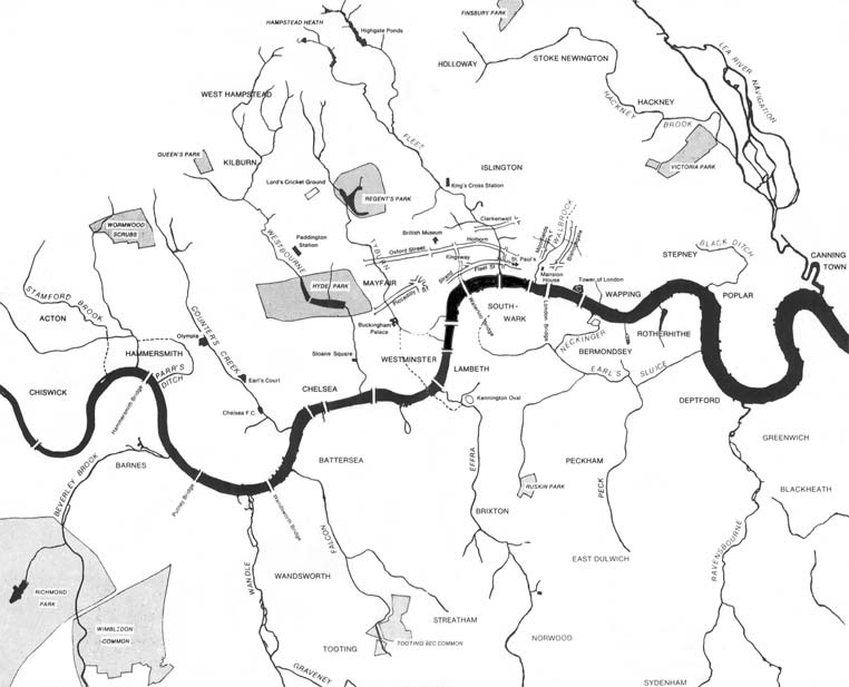
A sketch map of some lost rivers

"London Before the Houses", map of pre-urban London from 1884.[1]
This position of a mouth of the Effra was made in the 13th century, reducing the winter marshiness of much of Southwark, it is today a combined sewer overflow. Storm combined (foul and surface water) sewerage flows into the Tideway by Vauxhall Bridge, with others pouring billions of such litres into this upper estuary each year, which can take 30 days to reach the sea, but will be properly treated by means of the Thames Tideway Tunnel
The subterranean or underground rivers of London are or were the direct or indirect tributaries of the upper estuary of the Thames (the Tideway), that were built over during the growth of the metropolis of London. They now flow through culverts,[2] with some of them now integral parts of London's sewerage system and diverted accordingly.[3]
Subterranean rivers in London[]
This list is incomplete; you can help by . (April 2013) |

North of the River Thames
- Black Ditch
- Hackney Brook
- The River Moselle[4] (all three subtributaries via the Lea)
- Muswell Stream[4] (sub-sub-tributary via Pymmes Brook)
- The Walbrook
- The River Fleet, crossing Fleet Street
- The River Tyburn
- The River Westbourne
- The Tyburn Brook
- Counter's Creek
- Stamford Brook
- Parrs Ditch
- River Brent (partially underground)
- River Rom (partially underground)

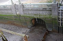
The culverted mouth of the Earl's Sluice at Deptford Wharf
South of the River Thames
- Earl's Sluice
- The River Peck
- The River Neckinger
- The River Effra
- Heathwall Ditch[5]
- The Falconbrook
- The Graveney (sub tributary due to the Wandle)
- The River Quaggy (partially underground) (sub tributary due to the Ravensbourne)
- The Beverley Brook (partially underground)
- Sudbrook (partially underground)
- sub-tributaries are shown indented
Development[]
In June 2008, the office of Mayor of London published outline plans to reinstate some underground rivers.[6] In January 2009, a partnership among the Environment Agency, Natural England, The River Restoration Centre, and the Greater London Authority set out a strategy for putting this into effect by creating the London Rivers Action Plan.[7][8]
See also[]
- Blue Ribbon Network – the major waterways of London
- List of rivers of England
- London sewerage system
- Subterranean London
- Subterranean river
- Tributaries of the River Thames
References[]
- ^ Loftie, William John (1884). A History of London (2nd ed.). London: Edward Stanford.
- ^ Nicholas Barton, The Lost Rivers of London, Historical Publications, ISBN 0-948667-15-X
- ^ Humphreys, Sir George W. (November 1930). Main Drainage of London (PDF). London: London County Council. p. 5. Retrieved 2 May 2019.
- ^ a b London's Lost Rivers (2011) Paul Talling, Random House, pp148-150 ISBN 9781847945976
- ^ "The Lost River Of London You've Never Heard Of: The Heathwall". Londonist.
- ^ "Boris Johnson to revive London's lost rivers". Times Online. London, UK. 5 September 2008.
- ^ "Environment Agency plans for river restoration". Environment-agency.gov.uk. UK. 2 March 2010. Archived from the original on 26 June 2009. Retrieved 25 July 2010.
- ^ "London Rivers Action Plan". The River Restoration Centre. UK. Archived from the original on 15 August 2009. Retrieved 25 July 2010.
Further reading[]
- Dangerfield, Andy (4 October 2015). "The lost rivers that lie beneath London". BBC News. London, UK.
- "The Underground City: Beneath the streets of London's capital city is a world of tunnels, rivers and hidden history". Heritage Magazine. April–May 2000. Archived from the original on 10 December 2002. Retrieved 10 December 2002.CS1 maint: bot: original URL status unknown (link)
External links[]
- "Deep Topographical site with special emphasis on London's lost watercourses". Middlexex County Council. Middlesex County, UK.
- Mackie, Gordon (January 2004). "London's Lost Rivers: Wayback Machine Snapshot". Archived from the original on 7 January 2004.CS1 maint: bot: original URL status unknown (link)
- "Map of London's Underground Rivers". OpenGuides.org. London, UK.
- "Photographs from inside London's 'Lost' Rivers". SilentUK.com.
- "Strange Maps". London's Lost Rivers.
Categories:
- Subterranean rivers of London
- Subterranean London