Sugarloaf Hill (Knockmealdowns)
| Sugarloaf Hill | |
|---|---|
| Cnoc na Binne | |
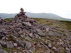 Summit cairn of Sugarloaf Hill | |
| Highest point | |
| Elevation | 663 m (2,175 ft)[1] |
| Prominence | 118 m (387 ft) |
| Listing | Hewitt |
| Geography | |
 Sugarloaf Hill Location in Ireland | |
| Location | County Tipperary / County Waterford, Ireland |
| Parent range | Knockmealdown Mountains |
| OSI/OSNI grid | S039105 |
| Topo map | OSi Discovery 74 |

Sugarloaf Hill (Irish: Cnoc na Binne) is a mountain peak located in the Knockmealdown Mountains on the border between County Tipperary and County Waterford.
See also[]
- List of mountains in Ireland
- Sugarloaf (mountain)
References[]
- ^ Hiking in Ireland, Helen Fairbairn, Gareth Mc Cormack, Lonely Planet, 2010, see Googlwe books
This article needs additional citations for verification. (January 2017) |
Mountains and hills of Munster | |||||||
|---|---|---|---|---|---|---|---|
| Ballyhoura Mountains |  | ||||||
| Boggeragh Mountains | |||||||
| Caha Mountains | |||||||
| Comeragh Mountains | |||||||
| Derrynasaggart Mountains | |||||||
| Dingle Peninsula |
| ||||||
| Galty Mountains | |||||||
| Iveragh Peninsula | |||||||
| Knockmealdown Mountains | |||||||
| MacGillycuddy's Reeks |
| ||||||
| Mangerton Mountains | |||||||
| Shehy Mountains | |||||||
| Silvermine Mountains | |||||||
| Slieve Miskish Mountains | |||||||
| Others |
| ||||||
Coordinates: 52°14′46″N 7°56′31″W / 52.246°N 7.942°W
This article related to the geography of County Tipperary, Ireland is a stub. You can help Wikipedia by . |
Categories:
- Hewitts of Ireland
- Mountains and hills of County Waterford
- Mountains and hills of County Tipperary
- Mountains under 1000 metres
- County Tipperary geography stubs