Supetar
Supetar | |
|---|---|
| Grad Supetar Town of Supetar | |
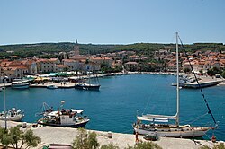 Supetar harbor | |
 Supetar Location of Supetar in Croatia | |
| Coordinates: 43°23′04″N 16°33′19″E / 43.38444°N 16.55528°E | |
| Country | |
| County | |
| Island | Brač |
| Government | |
| • Mayor | Ivana Marković (SDP) |
| Area | |
| • Town | 30 km2 (10 sq mi) |
| Elevation | 0 m (0 ft) |
| Population (2011)[1] | |
| • Urban | 3,213 |
| • Metro | 4,074 |
| Time zone | UTC+1 (CET) |
| • Summer (DST) | UTC+2 (CEST) |
| Postal code | 21 400 |
| Area code(s) | 021 |
| Licence plate | ST |
| Website | www |

Supetar (Croatian pronunciation: [sǔpetar], Italian: San Pietro della Brazza) is a town on the northern side of the Dalmatian island of Brač, in the Split-Dalmatia County, in Croatia. It became the island's official centre in 1827.[2] The Town of Supetar includes Supetar itself and the three villages: Splitska, Škrip and Mirca.
With a population of 3,213, it is the island's largest town. It is accessible by ferry (Jadrolinija, the ferry ride from the mainland city of Split takes 45 minutes) or via Brač Airport which is located 30 kilometres to the southeast.
History[]

Old Supetar was situated on the small peninsula where there is now a graveyard. The settlement came to an end during the early Christian era. In the late Middle Ages a new settlement started around the bay known as St. Peter's, from which the town derives its name. It originated from Sv. Petar during the Latin population of the town. "Sv" stands for "Sveti", meaning saint, therefore it takes its name from Saint Peter, which is the name's English equivalent translation.
The present settlement of Supetar was founded in the 16th century when people living in Nerežišća, about 8 kilometres (5 miles) inland, began to use it as their harbour. The town's main period of development occurred during the 18th and 19th centuries when Supetar took over from Nerežišća as the administrative centre of the island of Brač.[3]
The town[]
The Parish church of St. Peter (Sveti Petar) stands on the side of an old chapel which was restored in 1773 in a Baroque architectural style. At that time it also received a new aisle and bell tower. It was extended in 1887. In the church there are paintings by the local artist Feliks Tironi from the second half of the 18th century and a Baroque altarpiece by an unknown Venetian artist of the 18th century.
In the old part of the church there are some gravestones with Croatian inscriptions and at the entrance to the church there is a font made of two large Gothic capitals. On the left of the church building there is a sundial and beneath it a sarcophagus with the date 1774 engraved. In the Sunday school classrooms there are paintings from the Venetian era (16th and 17th centuries). The well, decorated with reliefs, is the work of Johannes Mazzonius from 1734.
Supetar graveyard beside the Chapel St. Nicholas (Sveti Nikola Putnik) there are two old Christian sarcophagi and several gravestones (Pieta), which are the work of Ivan Rendić of Supetar (1849–1932), and the mausoleum of the Petrinović family with portraits and sculptures, by the sculptor Toma Rosandić (1878–1958).
Supetar in the news[]
Slobodna Dalmacija daily recently reported that a housing development called Adriatica is being built in McKinney, Texas, United States, by real estate developer Jeff Blackard as a partial faithful replica of Supetar.[4]
References[]
- ^ "Population by Age and Sex, by Settlements, 2011 Census: Supetar". Census of Population, Households and Dwellings 2011. Zagreb: Croatian Bureau of Statistics. December 2012.
- ^ Naklada Naprijed, The Croatian Adriatic Tourist Guide, pg. 274, Zagreb (1999), ISBN 953-178-097-8
- ^ Jane Foster, Footprint Croatia, pg. 237, Footprint Handbooks (2004), ISBN 1-903471-79-6
- ^ A Million Dollars for a Villa in American Supetar, article on Adriatica McKinney in Slobodna Dalmacija (in Croatian)
External links[]
| Wikimedia Commons has media related to Supetar. |
- Supetar Tourist Board
- Supetar at Geonames.com
- Supetar-Brač Online
Coordinates: 43°23′04″N 16°33′19″E / 43.38444°N 16.55528°E
| show Subdivisions of Split-Dalmatia County |
|---|

| show Authority control |
|---|
- Cities and towns in Croatia
- Populated coastal places in Croatia
- Brač
- Populated places in Split-Dalmatia County