Supur, Birbhum
- For commune in Romania see Supur
Supur | |
|---|---|
Village | |
 Supur village | |
 Supur Location in West Bengal | |
| Coordinates: 23°37′37″N 87°40′53″E / 23.627022°N 87.681472°ECoordinates: 23°37′37″N 87°40′53″E / 23.627022°N 87.681472°E | |
| Country | |
| State | West Bengal |
| District | Birbhum |
| Population (2011) | |
| • Total | 1,803 |
| Languages | |
| • Official | Bengali, English |
| Time zone | IST |
| PIN | 731204 |
| Telephone/ STD code | 03463 |
| Lok Sabha constituency | Bolpur |
| Vidhan Sabha constituency | Bolpur |
| Website | birbhum |


Supur is a village under Raipur-Supur gram panchayat in Bolpur Sriniketan CD block in Bolpur subdivision of Birbhum district, West Bengal, India.
History[]
As per mythology, in ancient times, Supur was the capital of Raja Surath. Some 150 years ago or a little earlier, Supur and Surul were better known places than Bolpur, then a small village, and Shantiniketan did not exist.[1]
Geography[]
Location[]
Supur is located at 23°37′37″N 87°40′53″E / 23.627022°N 87.681472°E.
Demographics[]
As per the 2011 Census of India, Supur had a total population of 1,803 of which 910 (50%) were males and 893 (50%) were females. Population below 6 years was 220. The total number of literates in Supur was 1,096 (69.24% of the population over 6 years).[2]
Transport[]
Supur is on National Highway 114.[3]

Culture[]
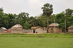
As seen in the photograph (alongside) there are two Shiva temples at Supur, referred to as twin Shiva temples. David J. McCutchion mentions that one of them is a 19th century ridged rekha deul, with rich terracotta decoration on all sides. The other one is a rekha deul with ridged turrets.[4]
Healthcare[]
There is a primary health centre at Supur (with 10 beds).[5]
References[]
- ^ Ghosh, Binoy, Paschim Banger Sanskriti, (in Bengali), part I, 1976 edition, page 298, Prakash Bhaban, Kolkata
- ^ "2011 Census – Primary Census Abstract Data Tables". West Bengal – District-wise. Registrar General and Census Commissioner, India. Retrieved 16 July 2019.
- ^ Google maps
- ^ McCutchion, David J., Late Mediaeval Temples of Bengal, first published 1972, reprinted 2017, pages 48 & 59. The Asiatic Society, Kolkata, ISBN 978-93-81574-65-2
- ^ "Health & Family Welfare Department". Health Statistics. Government of West Bengal. Retrieved 2 August 2019.
Cities, towns and locations in Birbhum district, West Bengal | |||||||
|---|---|---|---|---|---|---|---|
| Cities, municipal and census towns |
| ||||||
| Locations other than cities and towns |
| ||||||
| See also |
| ||||||
- Villages in Birbhum district