Surrey Iron Railway
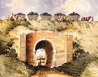 Watercolour showing the Croydon, Merstham and Godstone Railway passing Chipstead Valley Road, Coulsdon, Surrey | |
| Overview | |
|---|---|
| Headquarters | Wandsworth |
| Locale | England |
| Dates of operation | 1802–1846 |
| Successor | |
| Technical | |
| Track gauge | 4 ft 2 in (1,270 mm) |
| Length | 9 miles (14 km) |
The Surrey Iron Railway (SIR) was a horse-drawn plateway that linked Wandsworth and Croydon via Mitcham, all then in Surrey but now suburbs of south London, in England. It was established by Act of Parliament in 1801, and opened partly in 1802 and partly in 1803.[1] It was a toll railway on which carriers used horse traction. The chief goods transported were coal, building materials, lime, manure, corn and seeds. The first 8+1⁄4 miles (13.3 km) to Croydon opened on 26 July 1803, with a branch line off from Mitcham to Hackbridge.
The Croydon, Merstham and Godstone Railway was built as an extension of the railway but by a separate company. It opened in 1805 and closed in 1838.[2]
The Surrey Iron Railway was commercially successful only briefly, until shortly after the opening of the canal between Croydon and London in 1809. It closed in 1846.[3]
Origins[]
By the end of the eighteenth century, a number of short plateways, such as those to the Caldon Low quarries and the Little Eaton Gangway, had been built. Their purpose was to convey a mineral to a nearby canal for onward transport.
The original plan for a transport connection between Wandsworth, on the River Thames, and the industries of the Wandle Valley had been a canal scheme, put forward in 1799, but doubts about the availability of water led to the adoption of a plateway. Contrary to popular belief, it was not the world's first railway authorised by Parliament independently of a canal: that was the Middleton Railway (1758). Nor was it the first public railway or the first railway company: both of those honours go to the Lake Lock Railway near Wakefield, Yorkshire.[4][5][6]
It received royal assent on 21 May 1801,[7][page needed] and work commenced immediately with William Jessop as engineer, George Leather as resident engineer,[7][page needed] and joint contractor with Benjamin Outram. The line started at a wharf on the Thames at Wandsworth, and ascended gently through Tooting and Mitcham to Pitlake Mead in Croydon. There was a branch from near the site of the Mitcham Junction to oil-cake mills at Hackbridge, and a number of spurs to mills and works.
The initial share capital was £50,000 to which a further £10,000 was added in 1805–1806. The final cost, including the dock at Wandsworth, was between £54,700 and £60,000.[8] The main traffic was coal, building materials, lime, manure, corn and seeds. Horses were the motive power, and passengers were never contemplated.
The railway was only briefly successful financially. It lost much traffic after the Croydon Canal opened in 1809, though the full effect was not felt until the canal acquired a rail link to the two railways in 1811. Later it suffered from the closure of the underground stone quarries at Merstham in the 1820s. It covered its costs, but was unable to update its technology or to keep the track in good repair.[9] It closed on 31 August 1846.
Operation[]

It was a public toll railway, providing a track for independent goods hauliers to use their own horses and wagons. The company did not operate its own trains. Sometimes it leased out the track and the dock, and sometimes it collected tolls and kept the line in repair itself.[10]
It was double-track plateway with a spacing of about five feet between the centres of the stone blocks. The gauge was recorded as 4 ft 2 in (1,270 mm),[11] the same as on the Croydon, Merstham and Godstone Railway.[7][page needed][note 1]
The rails were of the Outram pattern 3 feet 2 inches (97 cm) long, 4 inches (10 cm) on the tread except for 5–6 inches (13–15 cm) at the ends where they were 1⁄2 inch (1.3 cm) thicker.[13]
Route[]

The nine-mile route followed the shallow valley of the River Wandle, then heavily industrialised with numerous factories and mills, from the River Thames at Wandsworth southwards to Croydon, at what is now Reeves Corner. A short branch ran from Mitcham to Hackbridge and Carshalton.[14] The railway was extended by a separate company as the Croydon, Merstham and Godstone Railway through Purley and Coulsdon to quarries near Merstham, opened in 1805 and closed in 1838.
History[]
The advent of faster and more powerful steam locomotives spelled the end for horse-drawn railways. In 1823, William James, a shareholder in the railway, tried to persuade George Stephenson to supply a locomotive. Stephenson realised that the cast-iron plateway could not support the weight of a locomotive and declined.[15]
In 1844 the proprietors sold the railway to the L&SWR, which sold it to the London and Brighton Railway so that the L&BR could use the trackbed to extend from Croydon to Earlsfield and then join the L&SWR line into Nine Elms and eventually Waterloo. However, the sale did not proceed, and on 3 August 1846 the Surrey Iron Railway obtained an Act of Parliament authorising its closure, which took place on 31 August 1846.[13] Part of the route was used for part of the West Croydon to Wimbledon Line, part of the LB&SCR from 1856, and some of the route is in use by London Tramlink: routes 3 & 4 between Wandle Park & Waddon Marsh, and route 3 at Mitcham.[13]
Croydon, Merstham and Godstone Railway[]
Before the railway was completed, it was proposed to extend it to Merstham and Godstone, and an Act for the purpose was obtained on 17 May 1803. The railway's directors were directors of the CM&GR, supplemented by Colonel Hylton Joliffe and Rev William John Joliffe, who had land and mineral interests on its route.
Work started quickly and it opened to Merstham on 24 July 1805 – it never reached Godstone. In 1809 or 1811 a short branch was built at Pitlake to the south side of the Croydon Canal basin. The track gauge was 4 ft 2 in (1,270 mm).[16]
See also[]
Notes[]
- ^ On a plateway, the gauge is taken as the dimension over the outer faces of the upstands. The standard gauge adopted by modern edge railways is 4 ft 8+1⁄2 in (1,435 mm). Referring to a Report on a Section of track excavated early in 1967 at Quarry Farm, Merstham, by Mr. W.G.Tharby ... on 10 March 1967, Turner says on page 25, "In a subsequent article not published until 1971 but referring to the 1967 excavations at Merstham, the gauge is given as 4ft 6in instead of the correct 4ft 2in. Since Mr. Tharby himself sponsored the special examination of the Merstham site it can only be assumed that error in his 1971 article was due to a misprint. See Tharby, W G, The Surrey Iron Railway."[12]
References[]
- ^ Gerhold 2010, pp. 193, 195.
- ^ Lee 1944, pp. 15, 25.
- ^ Lee 1944, p. 26.
- ^ Goodchild, J. (1977). The Lake Lock Railroad. Wakefield MDC Libraries. passim.
- ^ Goodchild, J. (2006). "The Lake Lock Railway". In Bailey, M. (ed.). Early Railways 3. pp. 40–50.
- ^ Gerhold 2010, p. 193.
- ^ a b c Turner 1977.
- ^ Gerhold 2010, pp. 198–9.
- ^ Gerhold 2010, pp. 200–4.
- ^ Gerhold 2010, p. 200.
- ^ Parliamentary Archives, 1846 Commons evidence, vol. 40, Surrey Iron Dissolving Railway Bill, 20 June, p. 81.
- ^ Turner 1977, p. 25.
- ^ a b c Gerhold 2010, pp. 207–9.
- ^ "The Surrey Iron Railway". Merton Historical Society. 3 March 2006. Archived from the original on 12 July 2017.
- ^ Rolt, L.T.C. (1962). Great Engineers. London: G Bell and Sons Ltd. p. 64.
- ^ Turner 1977, p. 17.
Sources[]
- Gerhold, Dorian (2010). "The Rise and Fall of the Surrey Iron Railway, 1802–46" (PDF). Surrey Archaeological Collections. 95: 193–210.
- Lee, Charles E. (1944). Early Railways in Surrey: the Surrey Iron Railway and its continuation the Croydon, Merstham & Godstone Iron Railway. London: Railway Gazette.
- Turner, John Howard (1977). The London Brighton and South Coast Railway: I – Origins and Formation. London: Batsford. ISBN 071340275X.
Further reading[]
- Shaw, Eric; Leyden, Kevin (2003). The Iron Railways of the Wandle Valley: a Bi-Centennial Anniversary Guide. Mitcham: Wandle Industrial Museum. ISBN 978-0-9539560-2-9.
- Burgess, Peter (March 1994). "The Use of Plate Rails in the Godstone Firestone Quarries". Proceedings of the Croydon Natural History and Scientific Society. 18 (4).
- Montague, E. N. (1971). "Wheels of the Surrey Iron Railway found at Mitcham" (PDF). Surrey Archaeological Collections. 68: 183.
- Bayliss, Derek A. (1981). Retracing the First Public Railway. Croydon: Living History Publications.
External links[]
- McGow, Peter (November 2001). "Surrey Iron Railway and Croydon, Merstham and Godstone Iron Railway, Notes on the Surrey Iron Railway".
- Surrey Iron Railway 200th: 26 July 2003 at Stephenson Locomotive Society 200th anniversary commemoration
- Croydon on Line: Surrey Iron Railway
Coordinates: 51°27′30.58″N 0°11′31.6″W / 51.4584944°N 0.192111°W

- 4 ft 2 in gauge railways in England
- Early British railway companies
- History of the London Borough of Croydon
- History of the London Borough of Merton
- History of Surrey
- History of transport in London
- History of the London Borough of Wandsworth
- Horse-drawn railways
- Rail transport in Surrey
- Railway companies established in 1801
- Railway companies disestablished in 1846
- Railway lines opened in 1803
- Transport in the London Borough of Croydon
- Transport in the London Borough of Merton
- Transport in the London Borough of Wandsworth
- 1801 establishments in England
- British companies established in 1801
- British companies disestablished in 1846