Sous
This article needs additional citations for verification. (October 2012) |
Sous
| |
|---|---|
Region | |
 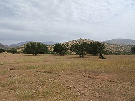 The Sous, here northeast of Taroudant, with Argan trees interplanted with cereal crops | |
 Sous Location in Morocco | |
| Coordinates: 30°05′N 8°29′W / 30.08°N 8.48°W | |
| Country | |
| Region | Souss-Massa, Guelmim-Oued Noun |

The Sous region (also spelt Sus, Suss, Souss or Sousse) (Arabic: سوس, romanized: sūs, Tachelhit: ⵙⵓⵙ, romanized: sus) is an area in mid-southern Morocco. Geologically, it is the alluvial basin of the Sous River (Asif n Sus), separated from the Sahara desert by the Anti-Atlas Mountains.[1] The natural vegetation in the Sous region is savanna dominated by the argan (Argania spinosa), a local endemic tree found nowhere else;[2] part of the area is now a UNESCO Biosphere Reserve to protect this unique habitat.[3] The region of Sous is generally fertile and has a high agricultural production.
History[]
A well irrigated area, this has been one of Morocco's most fertile regions for centuries, known since at least the eleventh century for its cultivation and export of olive and sugar. The golden age of the Sous was in the seventeenth century during the era of the kingdom of Tazerwalt, when the region enjoyed autonomy and profited from both the trans-Saharan gold trade and the sale of sugar to Portuguese, Dutch and English traders. The centre for foreign trade during this time was Agadir, a city 10 km north of the mouth of the Sous river.
Medieval Arabic geographers generally divided the Sous region into two distinct sub-regions: al-Sūs al-Aqṣā, or "farther Sus", and al-Sūs al-Adnā, or "nearer Sus".[4][5][6] Sus al-Aqsa consisted of the southern/western part, and Sus al-Adna consisted of the northern/eastern part; however, there were never any precise boundaries between the two.[6] The capital of the Sous was at Igli.[7] There was also a ribat at Massa near the Atlantic coast.[7]
Ibn Hawqal makes conflicting claims about the religious makeup of the Sous region at his time.[7] In one passage, he says that its inhabitants were Shi'is, but in another he says that the region was divided between Sunnis of the Maliki school and Shi'is, who he calls "Mūsawiyyun".[7] Tensions were high between these groups, he wrote, and there was a lot of warfare between them.[7]
Around 683, Uqba ibn Nafi conquered the Sous region, but after his death in 688 his conquests in Morocco slipped out of Muslim control.[7] The Sous was reconquered around 20 years later by Musa ibn Nusayr, who began the spread of Islam among the local population.[7]
Population[]
The Sous is inhabited by Amazigh-speaking peoples of Imesmoden and Iẓnagen; aside from some Arabic-speaking tribes, the main inhabitants are the Shilha people, speakers of a distinct Berber language known as Shilha or Tachelḥit.
Bibliography[]
- Boogert, Nico van den. The Berber Literary Tradition of the Sous: with an edition and translation of 'The Ocean of Tears' by Muḥammad Awzal (d. 1749), Leiden: Nederlands Instituut voor het Nabije Oosten, 1997. ISBN 90-6258-971-5
- Montagne, Robert. Les Berbères et le Makhzen dans le sud du Maroc; essai sur la transformation politique des Berbères sédentaires (groupe Chleuh). Rabat: Dar Al-Aman, 2013 ISBN 9954-561-35-8.
- UNESCO Arganeraie Biosphere Reserve
References[]
- ^ Allah, Redouane Choukr; Ragab, Ragab; Bouchaou, Lhoussaine; Barceló, Damià (2017-02-25). The Souss‐Massa River Basin, Morocco. Springer. p. 30. ISBN 9783319511313.
- ^ Allah, Redouane Choukr; Ragab, Ragab; Bouchaou, Lhoussaine; Barceló, Damià (2017-02-25). The Souss‐Massa River Basin, Morocco. Springer. p. 103. ISBN 9783319511313.
- ^ Ham, Anthony; Hardy, Paula (2007). Morocco. Ediz. Inglese. Lonely Planet. p. 389. ISBN 9781740599740.
- ^ Lévi Provençal, E. (1913–1936). "al-Sūs al-Aḳṣā". Brill Encyclopaedia of Islam, First Edition (Web). ISBN 9789004082656. Retrieved 8 March 2022.
{{cite book}}: CS1 maint: date format (link) - ^ Mohamed, Mohamed Hassan (2012). Between Caravan and Sultan: The Bayruk of Southern Morocco: A Study in History and Identity. Leiden, Boston: Brill. pp. 19–20. ISBN 978-90-04-18382-7. Retrieved 8 March 2022.
- ^ a b Coppée, Henry (1881). History of the Conquest of Spain by the Arab-Moors: With a Sketch of the Civilization which They Achieved, and Imparted to Europe, Volume 1. Boston: Little, Brown, & Company. pp. 68, 190, 351. Retrieved 8 March 2022.
- ^ a b c d e f g Jenkins, R. G. (1979). "'Abd Allāh b. Yāsīn and the Almoravids". In Willis, John Ralph (ed.). Studies in West African Islamic History: Volume 1: The Cultivators of Islam, Volume 2: The Evolution of Islamic Institutions & Volume 3: The Growth of Arabic Literature. Abingdon: Routledge. pp. 81–3. ISBN 0-7146-137-6, 0-7146-137-7. Retrieved 8 March 2022.
{{cite book}}: Check|isbn=value: invalid character (help)
External links[]
- Geography of Morocco