Taq-e Gara
This article does not cite any sources. (January 2013) |
This article may be expanded with text translated from the corresponding article in Persian. (January 2013) Click [show] for important translation instructions.
|
| Taq-e Gara | |
|---|---|
 | |
| Location | , Sarpol-e Zahab, Kermanshah Province, Iran |
| Coordinates | 34°25′54″N 46°01′04″E / 34.4318°N 46.0177°ECoordinates: 34°25′54″N 46°01′04″E / 34.4318°N 46.0177°E |
| Height | 11.7 m |

Taq-e Gara or some times Taq-e Shirin is a stone structure in Iran which is Belonging to the Sasanian Empire. It is built in the in the heights where is known as the in Kermanshah Province of Iran. This structure is located in the way from Kermanshah to Sarpol-e Zahab, on the 15th kilometer from Sarpol-e Zahab; beside of an ancient paving which connect Iranian Plateau to Mesopotamia. Due to changes of the path, now it is located below the road slope.
Design and construction[]
There are conflicting views as to the time of its construction. Parthian and Sassanid eras have been proposed, but most archeologists and historians believe that it has been built during late Sassanid Empire for a variety of reasons.
Access and attributes[]
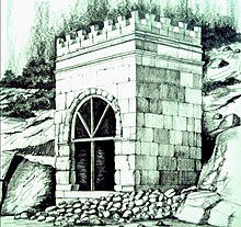
The monument is located on the old road from Kermanshah to Qasr-e Shirin with the new road overlooking it. It is about a five hundred meters walk away from the main road.
See also[]
Sassanid Empire
References[]
This section is empty. You can help by . (January 2013) |
External links[]
| Wikimedia Commons has media related to Taq-e Gara. |
- Sasanian architecture
- Archaeological sites in Iran
- Buildings and structures in Kermanshah Province