Taravai
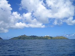 View of Taravai | |
 Taravai | |
| Geography | |
|---|---|
| Location | Pacific Ocean |
| Coordinates | 23°08′12″S 135°01′33″W / 23.13667°S 135.02583°WCoordinates: 23°08′12″S 135°01′33″W / 23.13667°S 135.02583°W |
| Archipelago | Tuamotus |
| Area | 5.7 km2 (2.2 sq mi) |
| Highest elevation | 256 m (840 ft) |
| Highest point | (unnamed) |
| Administration | |
France | |
| Overseas collectivity | French Polynesia |
| Administrative subdivision | Tuamotus |
| Commune | Gambier Islands |
| Largest settlement | Agonoko |
| Demographics | |
| Population | 9[1] (2012) |

Taravai is the second largest island in the Gambier Islands of French Polynesia, at 5.7 km². Taravai is about 1.5 km southwest of Mangareva and about 300 m north of the island of Angakauitai. Off its eastern shore lies the tiny rock Îlot Motu-o-ari.
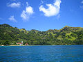
The village named Agonoko is located near the main bay on the island's eastern shore. It has a population of 9 (as of 2012). Former villages were Aga-nui (northwest) and Agakau-i-uta (southeast).[2]
The Onemea archaeological site suggests sporadic occupation of the island around AD 950 with a possible continuous settlement since the 13th century.[3]
Before the conversion to Christianity, the king of Taravai was a vassal to the king of Rikitea in Mangareva.[4]
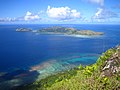
View of Taravai and Angakauitai from

Church of Saint-Gabriel
Taravai


References[]
- ^ "Population". Institut de la statistique de la Polynésie française. Retrieved 14 October 2014.
- ^ Goodbye Gambiers
- ^ The Onemea site (Taravai Island, Mangareva) and the human colonization of Southeastern Polynesia. Archaeology in Oceania
- ^ R. W. Williamson, The Social and Political Systems of Central Polynesia, Cambridge University Press, 1924
External links[]
| Wikimedia Commons has media related to Taravai. |
| hide | |||
|---|---|---|---|
Tuamotus Gambiers | Islands/Atolls | ||
| Island groups | |||
This French Polynesia-related geography article is a stub. You can help Wikipedia by . |
- Islands of the Gambier Islands
- French Polynesia geography stubs