Tarawera Falls
| Tarawera Falls | |
|---|---|
 Tarawera Falls at high flow | |
| Location | Bay of Plenty, New Zealand |
| Type | Plunge |
| Total height | 65m |
| Watercourse | Tarawera River |
| Tarawera Falls | |
|---|---|
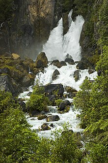 Lower part of Tarawera Falls, gushing out of fissures in the cliff | |
| Type | Cascade |
| Total height | 35m |
| Watercourse | Tarawera River |
Tarawera Falls is a 65 m high waterfall on the Tarawera River in the Bay of Plenty region in New Zealand's North Island.
The Tarawera River flows out of Lake Tarawera and across a rhyolitic lava flow that erupted from Mt Tarawera about 11,000 years ago. The river disappears about 30 metres back from the clifftop into flooded caves in the lava and pours out halfway up the cliff on the far side of the flow.[1][2]
After rain, part of the flow passes over the top of the cliff as a 65 m tall companion fall.
Access is from the town of Kawerau and is a drive of about 45 minutes over unsealed roads, followed by a walk of about 20 minutes.[3] A forestry access permit is required, available from the Information Centre in Kawerau.[2]
Māori history[]
The Te Arawa and Ngāti Awa tribes have traditional associations with this site. Ngāti Rangitihi, one of the eight Te Arawa tribal groups, are the current guardians of the area and consider the site of the waterfall a sacred place.[4]
Fauna and flora[]
The vegetation in the area has only developed since the 1886 Tarawera eruption and contains an unusual range of hybrids between pohutukawa and rata.[2] Migrating eels swim as far up as the waterfall and can sometimes be seen on the weastern[clarification needed] side of the falls searching for a way further upstream.[1]
References[]
- ^ a b Information contained on "An Underground River" information panel at the end of the track.
- ^ a b c "Tarawera Falls Track". Department of Conservation NZ. Retrieved 20 July 2020.
- ^ "Tarawera Falls". World of Waterfalls. Retrieved 30 August 2014.
- ^ Information contained on "Nga Wai O Hape" information panel at the waterfall.
External links[]
| Wikimedia Commons has media related to Tarawera Falls. |
Coordinates: 38°09′47″S 176°31′12″E / 38.163°S 176.52°E

This Bay of Plenty geography article is a stub. You can help Wikipedia by . |
This waterfall-related article is a stub. You can help Wikipedia by . |
- Rotorua Lakes District
- Landforms of the Bay of Plenty Region
- Waterfalls of New Zealand
- Bay of Plenty Region geography stubs
- Waterfall stubs