Taungdwingyi
This article needs additional citations for verification. (December 2011) |
Taungdwingyi
တောင်တွင်းကြီး Ponnawaddy | |
|---|---|
Town | |
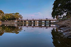 Kandawgyi Lake of Taungdwingyi | |
| Nickname(s): Taungdwin | |
 Taungdwingyi | |
| Coordinates: 20°01′N 95°33′E / 20.017°N 95.550°E | |
| Country | |
| Division | |
| District | Magway District |
| Township | Taungdwingyi Township |
| Area Code | |
| Altitude | |
| Population | 145,909 |
| Demographics | |
| • Ethnicities | chiefly Bamar |
| Time zone | UTC+06:30 (MST) |
| Website | www |

Taungdwingyi (Burmese: တောင်တွင်းကြီး [tàʊɰ̃dwɪ́ɰ̃dʑí]) is a town located in Magway Region, Myanmar.
Town scape[]

The town is divided into ten main quarters. They are Ohndaw Quarter 1, Ohndaw Quarter 2, Taungbyin Quarter 1, Taungbyin Quarter 2, Shwe-oh Quarter 1, Shwe-oh Quarter 2, Maungdaing Quarter 1, Maungdaing Quarter 2, Shwe Kya-in Quarter 1 and Shwe Kya-in Quarter 2. At the center of the town are the Myoma Zay central market, and the Independence Park. The Kandawgyi Lake, which used to be a weir in ancient times, is located on the east side, and is ringed by a number of historic Buddhist monasteries. Zeya Mingala Shweindaung is the most sacred pagoda in the township. The Aung Myin Zeya Rakhine Pagoda located at the western part of the town is the largest pagoda in the township. Once, it was in a state of decay and renovation was finished in 2013.
Economy[]
Economic of this town is based on agriculture and trading agricultural products. Onion, Rice, beans, grains, sugarcane are grown. Peanut oil is also a major product of the town.
Transportation[]
Taungdwingyi is connected to Magway (68 kilometres (42 mi)) to the West, Pyay (162 kilometres (101 mi)) to the South and Naypyidaw (68 kilometres (42 mi)) to the East, by means of territorial roads and railways. By the territorial roads, it is 227 kilometres (141 mi) to Mandalay and 365 kilometres (227 mi) to Yangon. The closest major airport is the Magway Airport (MWQ).
History[]
The Taungdwingyi region is one of the earliest inhabited regions in Myanmar. The Pyu city of Beikthano was founded around 200 BCE.[1] In 1278, a member of the Pagan royalty, Thihapate reestablished Taungdwingyi.[citation needed] In 1480, King Minkhaung II sent Lord to administer the town. During the Ava period (1364–1555), the region produced a number of famous poets and writers such as , , and Shin Maha Thilawuntha, and .[citation needed]
Weather[]
April is warmest with an average temperature of 39 °C (102 °F) at noon. January is coldest with an average temperature of 14 °C (57 °F) at night. Temperatures drop sharply at night. January is on average the month with most sunshine. The wet season has a rainfall peak around August, the dry season is around the month of March.
Nature[]
Taungdwingyi has a humid (> 0.65 p/pet) climate. The climate is classified as a tropical monsoon (short dry season, monsoon rains other months), with a subtropical dry forest biozone . The soil in the area is high in nitosols, andosols (nt), soil with deep, clay-enriched lower horizon with shiny ped surfaces.
See also[]
References[]
- ^ Aung-Thwin, Michael (2005). The mists of Rāmañña: The Legend that was Lower Burma (illustrated ed.). Honolulu: University of Hawai'i Press. pp. 18–19. ISBN 9780824828868.
| hide | ||
|---|---|---|
Capital: Magway | ||
| Gangaw District |   | |
| Magway District | ||
| Minbu District | ||
| Pakokku District | ||
| Thayet District | ||
| Main cities and towns | ||
| show Authority control |
|---|
- Populated places in Magway Region
- Township capitals of Myanmar