Te Mata Peak
| Te Mata Peak | |
|---|---|
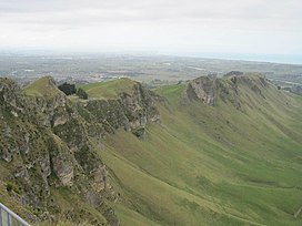 A view from Te Mata Peak | |
| Highest point | |
| Elevation | 399 m (1,309 ft) |
| Coordinates | 39°42′05″S 176°54′33″E / 39.70139°S 176.90917°ECoordinates: 39°42′05″S 176°54′33″E / 39.70139°S 176.90917°E |
| Geography | |
 Te Mata Peak | |
| Climbing | |
| Easiest route | Road |

Te Mata Peak is a peak south of Hastings rising up to 399m in the Te Mata Hills in the Hawke's Bay region of New Zealand.[1] A sealed road leads to the popular lookout at the summit, as well as several trails for hikers and mountain bikers.[2] The Hastings suburb of Havelock North is situated at the base of the peak.
As the highest peak in the area, it offers views over the Heretaunga Plains, and Hawke's Bay, including Napier. On a clear day, the view stretches as far as Mount Ruapehu and Māhia Peninsula.[3][4] Beneath Te Mata Peak rests the vineyard and the Tukituki River.[5]
The name originates from the name of the hillscape in Māori, Te Mata-o-Rongokako, or "the face of Rongokako". Rongokako was an ancestor of the Ngāti Kahungunu and the area is believed to be his final resting place.[6] When looking at the peak from the north, it appears to be the silhouette of a person lying down, which is said to be Rongokako.[7][8] European settlers called the peak the "Sleeping Giant", a name which is still in use today.[9][10]
The government bought the land from the local iwi in 1850, and it was subsequently purchased by John Chambers in the 1850s for use as a farming station.[7][11] The land was gifted to the public as a park in perpetuity in 1927 by his descendants.[1][7]
In October 2019 the Hastings District Council began work on filling in 1.3 km of a controversial walking track. The track had been cut by Craggy Range Winery in 2017, the local council having granted consent without informing the local iwi.[12]
References[]
- ^ a b Pollock, Kerryn. "Story: Hawke's Bay places". Te Ara – the Encyclopedia of New Zealand. Retrieved 27 January 2022.
- ^ "Visit the Beauty". Te Mata Peak. Retrieved 27 January 2022.
- ^ "Te Mata Peak". Hawke's Bay Food & Wine Country. Retrieved 27 January 2022.
- ^ Percival, Jo. "Take in the views from Te Mata Peak". AA. Retrieved 27 January 2022.
- ^ Jefferson, Shea (26 August 2021). "Craggy Range named 'world's most Instagramable vineyard'". The New Zealand Herald. Retrieved 27 January 2022.
- ^ Charles Royal, Te Ahukaramū. "Te Mata Peak". Te Ara – The Encyclopedia of New Zealand. Retrieved 27 January 2022.
- ^ a b c Whaanga, Piripi (20 February 2021). "Rongokako's name is missing from Te Mata Peak's entrance. It cannot be erased". The New Zealand Herald. Retrieved 27 January 2022.
- ^ Pollock, Kerryn. "Roadside Stories: Te Mata Peak, Hawke's Bay giant". Te Ara – the Encyclopedia of New Zealand. Retrieved 27 January 2022.
- ^ "Legend of Te Mata Peak is a tragic love story". The New Zealand Herald. 4 November 2017. Retrieved 27 January 2022.
- ^ Hall, Linda (28 November 2011). "Te Mata's sleeping giant comes to life". Hawkes Bay Today. Retrieved 27 January 2022.
- ^ McGibbon, Ian. "Chambers, John". Dictionary of New Zealand Biography. Ministry for Culture and Heritage. Retrieved 26 January 2022.
- ^ Sharpe, Marty (14 October 2019). "Blessing marks beginning of final chapter in Te Mata Peak track saga". Dominion Post. Retrieved 27 January 2022.
This Hawke's Bay Region geography article is a stub. You can help Wikipedia by . |
- Hastings District
- Mountains of the Hawke's Bay Region
- Hawke's Bay Region geography stubs