Teddington, New Zealand
Teddington | |
|---|---|
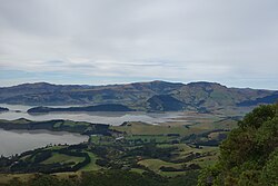 Looking northeast, with in the lower left of the picture and Te Wharae / Charteris Bay in the centre | |
 | |
| Coordinates: 43°40′06.24″S 172°39′40.81″E / 43.6684000°S 172.6613361°ECoordinates: 43°40′06.24″S 172°39′40.81″E / 43.6684000°S 172.6613361°E | |
| Country | New Zealand |
| Region | Canterbury |
| Local authority | Christchurch City Council |
| Ward | Banks Peninsula |
| Area | |
| • Total | 46.15 km2 (17.82 sq mi) |
| Population (June 2021)[2] | |
| • Total | 260 |
| • Density | 5.6/km2 (15/sq mi) |
| Time zone | UTC+12 (NZST) |
| • Summer (DST) | UTC+13 (NZDT) |


Teddington is a very small community on the Banks Peninsula at the head of Lyttelton Harbour / Whakaraupō. It sits on the junction of the road to and the road from Purau to Christchurch.
It dates back to the early settlers of Christchurch[3] but is now reduced to a pub and a restored working blacksmith's forge.[4]
Tsunami[]
An earthquake near Chile on 23 May 1960 caused a tsunami which crossed the Pacific to hit New Zealand. The tsunami was funnelled up Lyttleton Harbour and flooded low-lying farmland and the Wheatsheaf Tavern in Teddington. [5] A similar event occurred in 2010 following an earthquake in Chile with three waves that were greater than two metres high inundating the head of the harbour around Teddington.[6]
An earlier tsunami occurred in 1868 following an earthquake off the coast of Peru. This caused an eight foot high wave to be funnelled up Lyttleton Harbour towards Teddington.[7]
Demographics[]
The Teddington statistical area, which extends from Governors Bay almost to Purau[8] and includes Ōtamahua / Quail Island, covers 46.15 km2 (17.82 sq mi).[1] It had an estimated population of 260 as of June 2021,[2] with a population density of 5.6 people per km2.
| Year | Pop. | ±% p.a. |
|---|---|---|
| 2006 | 207 | — |
| 2013 | 192 | −1.07% |
| 2018 | 234 | +4.04% |
| Source: [9] | ||
Teddington had a population of 234 at the 2018 New Zealand census, an increase of 42 people (21.9%) since the 2013 census, and an increase of 27 people (13.0%) since the 2006 census. There were 87 households. There were 117 males and 114 females, giving a sex ratio of 1.03 males per female. The median age was 46.5 years (compared with 37.4 years nationally), with 36 people (15.4%) aged under 15 years, 39 (16.7%) aged 15 to 29, 114 (48.7%) aged 30 to 64, and 42 (17.9%) aged 65 or older.
Ethnicities were 97.4% European/Pākehā, 5.1% Māori, and 2.6% Pacific peoples (totals add to more than 100% since people could identify with multiple ethnicities).
The proportion of people born overseas was 25.6%, compared with 27.1% nationally.
Although some people objected to giving their religion, 57.7% had no religion, 33.3% were Christian, 1.3% were Buddhist and 1.3% had other religions.
Of those at least 15 years old, 75 (37.9%) people had a bachelor or higher degree, and 18 (9.1%) people had no formal qualifications. The median income was $39,300, compared with $31,800 nationally. The employment status of those at least 15 was that 105 (53.0%) people were employed full-time, 33 (16.7%) were part-time, and 3 (1.5%) were unemployed.[9]
References[]
- ^ a b "ArcGIS Web Application". statsnz.maps.arcgis.com. Retrieved 14 October 2021.
- ^ a b "Population estimate tables - NZ.Stat". Statistics New Zealand. Retrieved 22 October 2021.
- ^ "Teddington". Victoria University of Wellington. 2008. Retrieved 7 November 2019.
- ^ "Unexpected Places -The blacksmith at Teddington". Stuff.co.nz. 8 April 2018. Retrieved 7 November 2019.
- ^ "Natural Hazards: Tsunami | East Coast LAB | Life at the Boundary". www.eastcoastlab.org.nz. Retrieved 17 October 2020.
- ^ "Tsunami are frequent visitors to New Zealand shores". Stuff. 12 July 2019. Retrieved 17 October 2020.
- ^ "8 Foot Tsunami Hits Banks Peninsula – 15th August 1868". Discover The Delights Of Peeling Back History. 14 August 1868. Retrieved 17 October 2020.
- ^ "Geographic bounday viewer Teddington". Stats NZ. Retrieved 18 November 2021.
- ^ a b "Statistical area 1 dataset for 2018 Census". Statistics New Zealand. March 2020. Teddington (332800). 2018 Census place summary: Teddington
- Banks Peninsula
- Suburbs of Christchurch
- Populated places in Canterbury, New Zealand