Tefé River
| Tefé River | |
|---|---|
 | |
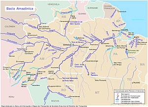 Tefé River center-left (west of Manaus) | |
| Location | |
| Country | Brazil |
| State | Amazonas |
| Physical characteristics | |
| Source | |
| • location | 5°26'05.5"S 66°55'44.5"W |
| Length | 450 km (280 mi)[1] |
| Discharge | |
| • average | 811 m3/s (28,600 cu ft/s) |
The Tefé River (Teffé River in early accounts; Portuguese: Rio Tefé) is a tributary of the Amazon River (Solimões section) in Amazonas state in north-western Brazil.
The Tefé River flows through the Juruá-Purus moist forests ecoregion.[2] It forms the eastern boundary of the Tefé National Forest, created in 1989.[3] Immediately before merging into the Amazon, it forms Lake Tefé (Portuguese: Lago Tefé). The city of Tefé is located on the banks of the lake. The Tefé River is a blackwater river.
See also[]
References[]
- ^ Ziesler, R.; Ardizzone, G.D. (1979). "Amazon River System". The Inland waters of Latin America. Food and Agriculture Organization of the United Nations. ISBN 92-5-000780-9. Archived from the original on 8 November 2014.
- ^ Sears, Robin, South America: Amazon Basin, northwestern Brazil (NT0133), WWF: World Wildlife Fund, retrieved 2017-03-28
- ^ FLONA de Tefé (in Portuguese), ISA: Instituto Socioambiental, retrieved 2016-10-19
Coordinates: 4°28′14″S 65°29′33″W / 4.47056°S 65.49250°W
Categories:
- Rivers of Amazonas (Brazilian state)
- Tributaries of the Amazon River
- Tefé
- Amazonas (Brazilian state) river stubs