Tenaja Canyon Creek
| Tenaja Canyon Creek[1] Tenaja Canyon | |
|---|---|
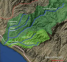 Map of San Mateo Creek and Arroyo San Onofre drainage basins. San Mateo Creek basin is in dark green. | |
| Location | |
| Country | United States |
| State | California |
| Region | Riverside County |
| Physical characteristics | |
| Source | at the head of , at the confluence of arroyos from , Redonda Mesa and Squaw Mountain highlands. |
| • coordinates | 33��30′23″N 117°21′51″W / 33.50639°N 117.36417°W |
| • elevation | 1,875 ft (572 m) |
| Mouth | confluence with San Mateo Creek near |
• coordinates | 33°31′46″N 117°24′32″W / 33.52944°N 117.40889°WCoordinates: 33°31′46″N 117°24′32″W / 33.52944°N 117.40889°W |
• elevation | 1,112 ft (339 m) |
| Length | 3.5 mi (5.6 km) |
| Discharge | |
| • location | Pacific Ocean |
| Basin features | |
| Tributaries | |
| • right | unnamed arroyo from Squaw Mountain highlands, unnamed arroyo from Squaw Mountain highlands |

Tenaja Canyon Creek, a stream or arroyo, tributary to San Mateo Creek, in the Cleveland National Forest in Riverside County, California. Its source is at an altitude of 1875 feet. The creek has its source at the confluence of arroyos from , Redonda Mesa and Squaw Mountain highlands.[2] and it flows northwestward 3+1⁄2 miles down to its mouth and its confluence near , at an elevation of 1112 feet with San Mateo Creek.[3][4] The word may refer to the arroyo El Portero del Tenaja or to the topographic structure.
References[]
- ^ U.S. Geological Survey Geographic Names Information System: Tenaja Canyon Creek
- ^ Tenaja Canyon Creek (source), USGS Map Name: Wildomar, CA, Map Center: N33° 30' 18" W117° 21' 46" from topoquest.com accessed on 5/11/2013
- ^ Tenaja Canyon, California (mouth), USGS Map Name: Sitton Peak, CA' Map Center: N33° 31' 46" W117° 24' 32", from topoquest.com accessed on 5/11/2013
- ^ Beatrice Dawson Wood, Gazetteer of Surface Waters of California, Pacific Coast Basins and Great Basin, U.S. Government Printing Office, Washington, 1913, p.217
This Riverside County, California-related article is a stub. You can help Wikipedia by . |
Categories:
- Rivers of Riverside County, California
- Santa Ana Mountains
- Cleveland National Forest
- Rivers of Southern California
- Riverside County, California geography stubs
- California river stubs