Terence Bay, Nova Scotia
Terence Bay | |
|---|---|
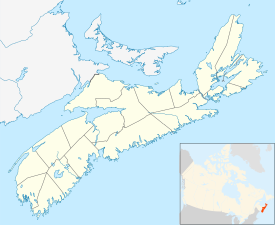 Terence Bay Location of Terence Bay, Nova Scotia | |
| Coordinates: 44°28′00″N 63°42′59″W / 44.46667°N 63.71639°WCoordinates: 44°28′00″N 63°42′59″W / 44.46667°N 63.71639°W | |
| Country | Canada |
| Province | Nova Scotia |
| Municipality | Halifax |
| Amalgamated with Halifax | April 1, 1996 |
| Government | |
| • Type | Halifax Regional Council |
| Area | |
| • Total | 3.37 km2 (1.30 sq mi) |
| Population | |
| • Total | 749 |
| • Density | 222/km2 (570/sq mi) |
| Time zone | UTC−04:00 (AST) |
| • Summer (DST) | UTC−03:00 (ADT) |
| Postal code span | B |
| Area code(s) | 782, 902 |
Part of a series about Places in Nova Scotia | |

Terence Bay (Canada 2016 Census population 749)[3] is a rural fishing community on the Chebucto Peninsula in the Halifax Regional Municipality, Nova Scotia. It is located on the shore of the Atlantic Ocean, 10 km off the Prospect Road, off Route 333, 21.2 kilometers from Halifax.
The community has the status of designated place in Canadian census data. Its name may also sometimes be seen as Terrence Bay, although Terence is the correct spelling.

History and local geography[]
The area, which is located at the tip of the Chebucto Peninsula, was originally settled in the early 1880s or possibly before, probably by Irish fishermen. Early records for the area include the 1827 Census of Halifax and the parish register of Our Lady of Mount Carmel (Roman Catholic), Prospect, whose entries begin in 1823 and include Terence Bay families. By the 1850s, the population of Terence Bay consisted mainly of the descendants of Irish and German immigrants to NS, many of whose descendants still reside there.
The origin of the name "Terence" in reference to the community is uncertain; theories have included that it is a mispronunciation or misspelling of "Terns", or of "Turner", although "Turner" is unknown in the community as a historical surname. What is certain is that the 1865 A. F. Church Map of Halifax County names it "Turns Bay".
The area in which Terence Bay is situated also contains the communities of Lower Prospect at which the RMS Atlantic disaster occurred, and Sandy Cove, at which a cemetery and monument to the wreck and an interpretive centre are located.
Communications[]
- Area code 902; Telephone exchanges - 852, 850
- Forward sortation area - B3T
Schools[]
Demographics[]
According to the 2016 release of population estimates, Terence Bay had 749 people over 3.37 km2 (1.30 sq mi). The area had a population density of approximately 222/km2, which is approximately 3 times more dense than the municipal average of 73.4/km2.[7]
References[]
- ^ "Census Profile, 2016 Census Terrence Bay, Class IV area [Designated place], Nova Scotia and Nova Scotia [Province]". www12.statcan.gc.ca. Statistics Canada. Retrieved 20 May 2021.
- ^ "Census Profile, 2016 Census Terrence Bay, Class IV area [Designated place], Nova Scotia and Nova Scotia [Province]". www12.statcan.gc.ca. Statistics Canada. Retrieved 20 May 2021.
- ^ "Census Profile, 2016 Census Terrence Bay, Class IV area [Designated place], Nova Scotia and Nova Scotia [Province]". www12.statcan.gc.ca. Statistics Canada. Retrieved 20 May 2021.
- ^ "Census Profile, 2016 Census Terrence Bay, Class IV area [Designated place], Nova Scotia and Nova Scotia [Province]". www12.statcan.gc.ca. Statistics Canada. Retrieved 20 May 2021.
- ^ "Census Profile, 2016 Census Terrence Bay, Class IV area [Designated place], Nova Scotia and Nova Scotia [Province]". www12.statcan.gc.ca. Statistics Canada. Retrieved 20 May 2021.
- ^ "Census Profile, 2016 Census Terrence Bay, Class IV area [Designated place], Nova Scotia and Nova Scotia [Province]". www12.statcan.gc.ca. Statistics Canada. Retrieved 20 May 2021.
- ^ "Census Profile, 2016 Census Terrence Bay, Class IV area [Designated place], Nova Scotia and Nova Scotia [Province]". www12.statcan.gc.ca. Statistics Canada. Retrieved 20 May 2021.
External links[]
This Halifax County, Nova Scotia location article is a stub. You can help Wikipedia by . |
- Communities in Halifax, Nova Scotia
- Designated places in Nova Scotia
- General Service Areas in Nova Scotia
- Halifax County, Nova Scotia geography stubs