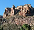
Terra Tower
| Terra Tower | |
|---|---|
 Northeast aspect | |
| Highest point | |
| Elevation | 5,790 ft (1,760 m)[1] |
| Prominence | 60 ft (18 m)[1] |
| Parent peak | Black Ridge[1] |
| Isolation | 3.76 mi (6.05 km)[1] |
| Coordinates | 39°04′12″N 108°40′40″W / 39.0699°N 108.6777°WCoordinates: 39°04′12″N 108°40′40″W / 39.0699°N 108.6777°W |
| Geography | |
 Terra Tower Location in Colorado | |
| Location | Colorado National Monument Mesa County, Colorado, U.S. |
| Parent range | Colorado Plateau Uncompahgre Plateau |
| Topo map | USGS Colorado National Monument |
| Geology | |
| Age of rock | Late Triassic to Early Jurassic[2] |
| Type of rock | Wingate Sandstone |
| Climbing | |
| First ascent | 1979 |
| Easiest route | class 5.11 climbing |
Terra Tower is a 5,790-foot-elevation (1,760 meter) sandstone pillar located in Colorado National Monument, in Mesa County of western Colorado, United States.[3] This 350-foot-high tower is situated on the Redlands escarpment, approximately seven miles west of the community of Grand Junction. Topographic relief is significant as it rises 1,000 feet (300 meters) above the Tiara Rado Golf Course in approximately one-half mile. The first ascent of the summit was made in 1979 by Harvey Carter and Tom Merrill via the class 5.11 route, Way Bazaar.
Geology[]
This tower is the remnant of a differentially eroded fin composed primarily of cliff-forming Wingate Sandstone, which consists of wind-borne, cross-bedded quartzose sandstones deposited as ancient sand dunes approximately 200 million years ago in the Late Triassic. The caprock at the summit consists of fluvial sandstones of the resistant Kayenta Formation. The slope around the base of Terra Tower is Chinle Formation.[4] Precipitation runoff from this geographical feature drains to the Colorado River, approximately two miles to the northeast.
Climate[]
According to the Köppen climate classification system, Terra Tower is located in a semi-arid climate zone.[5] Summers are hot and dry, while winters are cold with some snow. Temperatures reach 100 °F (38 °C) on 5.3 days, 90 °F (32 °C) on 57 days, and remain at or below freezing on 13 days annually. The months April through October offer the most favorable weather to visit.
Climbing[]
Established rock climbing routes on Terra Tower:[6]
- Way Bazaar – class 5.11 First ascent 1979
- Tom Stubbs Memorial Route – class 5.11 – 4 pitches – FA 2012 – James Stover, Doug McKee
Gallery[]
See also[]
References[]
- ^ a b c d "Terra Tower - 5,790' CO". listsofjohn.com. Retrieved 2021-07-15.
- ^ Geologic Formations, National Park Service
- ^ Stewart M. Green, 2019, Rock Climbing Colorado A Guide to More Than 1,800 Routes, Falcon Guides, ISBN 9781493037353, page 463.
- ^ Stanley William Lohman, The Geologic Story of Colorado National Monument, Geological Survey Bulletin 1508, pages 28-30.
- ^ Peel, M. C.; Finlayson, B. L.; McMahon, T. A. (2007). "Updated world map of the Köppen−Geiger climate classification". Hydrol. Earth Syst. Sci. 11. ISSN 1027-5606.
- ^ Stewart M. Green, 2019, Rock Climbing Colorado A Guide to More Than 1,800 Routes, Falcon Guides, ISBN 9781493037353, page 465.
External links[]
- Terra Tower rock climbing: Mountainproject.com
- Terra Tower from golf course (photo): Flickr
- Weather forecast: National Weather Service
- Colorado Plateau
- Landforms of Mesa County, Colorado
- Colorado National Monument
- North American 1000 m summits
- Sandstone formations of the United States
- Rock formations of Colorado


