Texelspitze
| Texelspitze | |
|---|---|
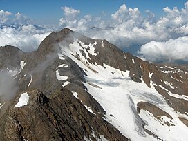 Texelspitze from Roteck | |
| Highest point | |
| Elevation | 3,318 m (10,886 ft) |
| Prominence | 145 m (476 ft) |
| Parent peak | Roteck |
| Isolation | 1 km (0.62 mi) |
| Coordinates | 46°43′15″N 10°58′17″E / 46.72083°N 10.97139°ECoordinates: 46°43′15″N 10°58′17″E / 46.72083°N 10.97139°E |
| Geography | |
 Texelspitze Location in the Alps | |
| Location | South Tyrol, Italy |
| Parent range | Ötztal Alps |
| Climbing | |
| First ascent | 22 jul 1871 by Theodor Petersen and his guides L. Ennemoser and J. Hellriegl |
| Easiest route | Over the southeast face |

The Texelspitze (Italian: Cima Tessa) is a mountain in the Texel group of the Ötztal Alps.
This Trentino-Alto Adige/Südtirol location article is a stub. You can help Wikipedia by . |
Categories:
- Mountains of South Tyrol
- Mountains of the Alps
- Alpine three-thousanders
- Ötztal Alps
- Trentino-Alto Adige/Südtirol geography stubs