Thị Nại Port
| Port of Thi Nai | |
|---|---|
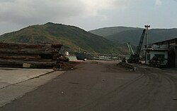 Thị Nại Port, against the mountains of Phuong Mai Peninsula. | |
| Location | |
| Country | Vietnam |
| Location | Quy Nhơn |
Thị Nại Port (Vietnamese: Cảng Thị Nại) is the second largest port in Bình Định Province, Vietnam. It is located in Hai Cang (meaning sea port) ward at the eastern tip of Quy Nhơn city. In 2009, 644 tons of goods were handled in Thị Nại Port, of which 113 tons were exported and 3 tons imported.[1]
History[]
Thị Nại was widely considered as the first port of Champa from the eleventh to the later of fifteenth century. At this time, Thị Nại played an important role in the trading between China, Southeast Asia and Southwest Asia countries. Thị Nại port was also a regional trading center of Champa.
After the Vietnamese destroyed the kingdom of Champa, Thị Nại kept playing its role as a trading port. Following the Tây Sơn rebellions, Thị Nại port became a naval port.
In mid 20th century, the government of South Vietnam rebuilt Thị Nại into a supporting naval port. After 1975, the Thị Nại port was continuously used as a naval port till recent years.
References[]
| Wikimedia Commons has media related to Thi Nai Port. |
- ^ Binh Dinh Statistics Office (2010): Binh Dinh Statistical Yearbook 2009. Statistical Publishing House, Hanoi
- (in Vietnamese) Đỗ Trường Giang (2008), The transformation of Cham's trade port into Viet one (the case of Thi Nai - Nuoc Man) [Sự chuyển hoá từ thương cảng Chăm sang Việt (trường hợp Thị Nại - Nước Mặn) ) Nghiên cứu Đông Nam Á . No 8. p. 71-76. ISSN 0868-2739.
- Thi Nai Seaport: Renovation for Development
- Quy Nhon at Columbia Encyclopedia.
| National and international ports | |
|---|---|
| National and regional ports | |
| Local ports | |

- Ports and harbours of Vietnam
- Buildings and structures in Bình Định province
- Geography of Bình Định province