Thaton
Thaton
| |
|---|---|
Town | |
 | |
 Thaton Location in Myanmar | |
| Coordinates: 16°56′N 97°22′E / 16.933°N 97.367°ECoordinates: 16°56′N 97°22′E / 16.933°N 97.367°E | |
| Country | |
| Division | |
| District | Thaton District |
| Population (2007) | |
| • Total | 130,763 |
| • Religions | Theravada Buddhism |
| Time zone | UTC+6.30 (MST) |
| Area code(s) | 57[1] |

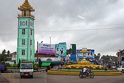
Thaton (Burmese: သထုံမြို့; MLCTS: sa. htum mrui.pronounced [θətʰòʊɰ̃ mjo̰]; Mon: သဓီု /kəthɜ̤m/[2]) is a town in Mon State, in southern Myanmar on the Tenasserim plains. Thaton lies along the National Highway 8 and is also connected by the National Road 85. It is 230 km south east of Yangon and 70 km north of Mawlamyine. Thaton was the capital of Thaton Kingdom from at least the 4th century BC to the middle of the 11th century AD.
Etymology[]
Thaton is the Burmese name of Sadhuim (သဓီု) in Mon, which in turn is from Sudhammapura (သုဓမ္မပူရ) in Pali, after Sudharma, the moot hall of the gods.[3]
History[]
Thaton was the capital of the Thaton Kingdom, a Mon Kingdom which ruled present day Lower Burma between the 4th and 11th centuries. Like the Burmans and the Thais, some modern Mons have tried to identify their ethnicity and, specifically this kingdom at Thaton, with the semi-historical kingdom of Suwarnabhumi ("The Golden Land"); today, this claim is contested by many different ethnicities in south-east Asia, and contradicted by scholars. Historical scholarship indicates that the early usage of the term (as found in the edicts of Ashoka of India, who sent Buddhist missionaries there in the 3rd century BC) indicated a location in southern India, and not in south-east Asia[citation needed].
In the kingdom of Dvaravati, Thaton was an important seaport on the Gulf of Martaban, for trade with India and Sri Lanka. Shin Arahan, also called , a monk born in Thaton and raised and educated in Nakhon Pathom, an old capital of the Mon kingdom of Dvaravadi, now in Thailand, took Theravada Buddhism north to the Burmese kingdom of Bagan. In 1057, King Anawrahta of Bagan conquered Thaton.
Geography[]
Silting has resulted in the coastline moving 16 kilometres (9.9 mi) away from Thaton, which is now a sleepy town on the rail line from Bago to Mawlamyine (Moulmein).
Climate[]
| hideClimate data for Thaton (1981–2010) | |||||||||||||
|---|---|---|---|---|---|---|---|---|---|---|---|---|---|
| Month | Jan | Feb | Mar | Apr | May | Jun | Jul | Aug | Sep | Oct | Nov | Dec | Year |
| Average high °C (°F) | 32.7 (90.9) |
34.3 (93.7) |
35.5 (95.9) |
36.0 (96.8) |
32.7 (90.9) |
29.6 (85.3) |
28.9 (84.0) |
28.7 (83.7) |
30.2 (86.4) |
32.3 (90.1) |
32.7 (90.9) |
31.9 (89.4) |
32.1 (89.8) |
| Average low °C (°F) | 17.3 (63.1) |
19.3 (66.7) |
22.4 (72.3) |
24.5 (76.1) |
24.3 (75.7) |
23.5 (74.3) |
23.2 (73.8) |
23.2 (73.8) |
23.4 (74.1) |
23.5 (74.3) |
21.5 (70.7) |
18.2 (64.8) |
22.0 (71.6) |
| Average rainfall mm (inches) | 1.4 (0.06) |
4.1 (0.16) |
18.4 (0.72) |
80.5 (3.17) |
555.8 (21.88) |
1,036.4 (40.80) |
1,213.8 (47.79) |
1,245 (49.02) |
739.1 (29.10) |
258.3 (10.17) |
55.9 (2.20) |
13.4 (0.53) |
5,222.1 (205.59) |
| Source: Norwegian Meteorological Institute[4] | |||||||||||||
Health care[]
- Thaton District Hospital
Education[]
Thaton is home to Computer University (Thaton), which offers five-year bachelor's degree programs in computer science and computer technology. It is also the home of .
References[]
- ^ "Myanmar Area Codes". Retrieved 2009-04-10.
- ^ Shorto, H.L. (1962). A Dictionary of Modern Spoken Mon. London: Oxford University Press.
- ^ Shorto, H.L. (2002). "The 32 myos in the medieval Mon Kingdom". In Vladimir Braginsky (ed.). Classical Civilisations of South East Asia: An Anthology of Articles Published in The Bulletin of the School of Oriental and African Studies. London and New York: Routledge. p. 204. ISBN 0-7007-1410-3.
- ^ "Myanmar Climate Report" (PDF). Norwegian Meteorological Institute. pp. 23–36. Archived from the original (PDF) on 8 October 2018. Retrieved 28 October 2018.
External links[]
| Wikimedia Commons has media related to Thaton. |
 Thaton (Myanmar) travel guide from Wikivoyage
- http://www.eumon.org/Script_kyanlyani.php
| hide | ||
|---|---|---|
Capital: Mawlamyine | ||
| Mawlamyine District |  | |
| Thaton District | ||
| Cities, towns, and villages |
| |
| show Authority control |
|---|
- Township capitals of Myanmar
- Populated places in Mon State
- Old Cities of Mon people