The Cabox
| The Cabox | |
|---|---|
 | |
| Highest point | |
| Elevation | 812 m (2,664 ft) |
| Prominence | 812 m (2,664 ft) |
| Listing |
|
| Coordinates | 48°49′59″N 58°29′03″W / 48.83306°N 58.48417°WCoordinates: 48°49′59″N 58°29′03″W / 48.83306°N 58.48417°W |
| Geography | |
 The Cabox | |
| Parent range | Long Range Mountains |
| Topo map | NTS 12B16 |
| Climbing | |
| First ascent | William Seaward (1832) |
| Easiest route | class 2 scramble |

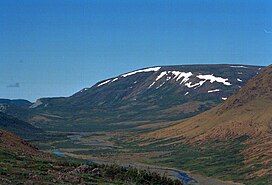
The Cabox is the highest mountain on the island of Newfoundland, located on the western part of the island near the coastal town of Stephenville.[1] It is 812 m (2,664 ft) high and is the central peak of the Lewis Hills of the Long Range Mountains, which are a subrange in the Appalachian Mountains.
See also[]
References[]
- ^ "The Cabox". Geographical Names Data Base. Natural Resources Canada.
This Newfoundland and Labrador location article is a stub. You can help Wikipedia by . |
Categories:
- Mountains of Newfoundland and Labrador
- Newfoundland and Labrador geography stubs