The Water Lanes, York

The Water Lanes were three medieval streets in the UK city of York. They led from Castlegate road down to the waterfront of the River Ouse. In the 19th century, they were known as the First Lane, Middle Lane and Far Water Lane, although in the 12th century they had been known as Kergate, Thrush Lane and Hertergate. They were demolished in 1852.[1]
History[]
The Lanes were similar in appearance to the Shambles with the jettied buildings hanging over the street. They consisted of three long streets lined with medieval buildings tightly packed in together leading to the river at the bottom.[2]
The lanes held great appeal for artists, who enjoyed capturing the long, narrow streets and the ramshackle buildings. In particular the artist John Ruskin and his associates did several drawings of the streets in Victorian times as well as the early Victorian pioneer of photography William Henry Fox Talbot.[3][4]
The Water Lanes also had the highest rates of poverty and crime in the City. The lanes were known for their unsanitary conditions and much of York's cholera problems started in these streets. The improvement commissioners in the 1840s discovered that the toilets facilities for the residents were nearly non-existent, noting that "the inhabitants have to use those of their neighbours by stealth or go into the street".
The police reports of the time made constant reference to the problems of crime in the streets, with offences ranging from murder to mugging, and even a case of a lady who was having her fortune told in a house on Water Lane, who found that her money had been taken from her during the reading.[5]
Demolition[]
Attempts were made over many decades to look at either improving or demolishing the lanes. In February 1830, the City Commissioners looked seriously at the "plan of the projected New Street from Low Ousegate, across the Water Lanes, and to the present entrance to the Castle". Although it obtained support, no firm action was decided for the area.
After continued debate, in the 1850s the City Corporation decided that the lanes should be demolished, although work didn't finish for around twenty years. During a meeting of York City Council in 1851 when the new road across the lanes was being discussed, one person noted that "the purpose of clearing away an immense amount of property which, they would all admit harboured a class of persons they would all desire to see out of the Water Lanes".[6]
In a bid to solve this problem, the Corporation of York took the decision in 1852 to clear them altogether, demolishing the buildings and creating a new road across where they ran – Clifford Street in 1880. The modern road Friargate, leading to Castlegate, follows the route of Hertergate, one of the Water Lanes.[7] Municipal buildings were established on the street, including, York's first library, York's magistrates court, the Liberal Club and a new police station and fire station.[1]
Gallery[]
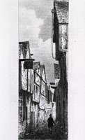
The First Water Lane in York in 1844 with a man walking down the lane, between rows of closely built houses.

An etching of a three-storey half-timbered house on Middle Water Lane, now Cumberland Street, York in 1840.

First Water Lane in York, with figures in street and cart. Two figures on right side in foreground.


References[]
- ^ a b "Water Lanes: History of York". www.historyofyork.org.uk. Retrieved 24 November 2020.
- ^ "Castlegate, York". Jorvik.co.uk. 30 January 2013. Retrieved 27 November 2020.
- ^ "The William Henry Fox Talbot Catalogue Raisonné". talbot.bodleian.ox.ac.uk. Retrieved 24 November 2020.
- ^ Buttery, Darrell (1995). The Vanished Buildings of York. York: Maxiprint. pp. 86–87. ISBN 1871125170.
- ^ Harrison, Laura. "Creating the slum: representations of poverty in the Hungate and Walmgate districts of York, 1875–1914" (PDF). Ex Historia: 68–71 – via University of Leeds.
- ^ a b "Water Lanes – York History". Retrieved 24 November 2020.
- ^ "Friargate | Secret York". secretyork.com. Retrieved 27 November 2020.
- ^ "In Water Lane, York. | York Museums Trust". www.yorkmuseumstrust.org.uk. Retrieved 24 November 2020.

- Medieval sites in England
- Buildings and structures demolished in 1852
- Historic sites in the United Kingdom
- History of York
- Streets in York