Thomas Viaduct
Thomas Viaduct | |
|---|---|
 | |
| Coordinates | 39°13′18″N 76°42′48″W / 39.22167°N 76.71333°WCoordinates: 39°13′18″N 76°42′48″W / 39.22167°N 76.71333°W |
| Carries | Railroad |
| Crosses | Patapsco River |
| Locale | Elkridge, Maryland |
| Owner | CSX Transportation |
| Heritage status | NRHP 66000388 |
| Characteristics | |
| Design | Arch bridge |
| Material | Patapsco granite |
| Total length | 612 feet (187 m) |
| Width | 26 feet 4 inches (8 m) |
| Height | 59 feet (18 m) |
| Longest span | 58 feet (18 m) |
| No. of spans | 8 |
| History | |
| Designer | Benjamin Henry Latrobe, II |
| Constructed by | John McCartney |
| Construction start | 1833 |
| Opened | July 4, 1835 |
Thomas Viaduct, Baltimore & Ohio Railroad | |
U.S. National Register of Historic Places | |
 | |
| Area | 0.5 acres (0.20 ha) |
| NRHP reference No. | 66000388[1] |
| Added to NRHP | October 15, 1966 |
| Location | |
 | |
| References | |
| [2] | |
The Thomas Viaduct spans the Patapsco River and Patapsco Valley between Relay, Maryland and Elkridge, Maryland, USA. It was commissioned by the Baltimore and Ohio Railroad (B&O); built between July 4, 1833, and July 4, 1835; and named for Philip E. Thomas, the company's first president.[3] It remains the world's oldest multiple arched stone railroad bridge.[4]
At its completion, the Thomas Viaduct was the largest railroad bridge in the United States[5] and the country's first multi-span masonry railroad bridge to be built on a curve. In 1964, it was designated as a National Historic Landmark. In 2010, the bridge was designated as a National Historic Civil Engineering Landmark by the American Society of Civil Engineers.
The viaduct is now owned and operated by CSX Transportation and still in use today, making it one of the oldest railroad bridges still in service.
Design[]
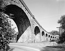
This Roman-arch stone bridge is divided into eight spans. It was designed by Benjamin Henry Latrobe, II, then B&O's assistant engineer and later its chief engineer. The main design problem to overcome was that of constructing such a large bridge on a curve. The design called for several variations in span and pier widths between the opposite sides of the structure. This problem was solved by having the lateral pier faces laid out on radial lines, making the piers essentially wedge-shaped and fitted to the 4-degree curve.[2]
The viaduct was built by John McCartney of Ohio, who received the contract after completing the Patterson Viaduct. Caspar Wever, the railroad's chief of construction, supervised the work.
The span of the viaduct is 612 feet (187 m) long; the individual arches are roughly 58 feet (18 m) in span, with a height of 59 feet (18 m) from the water level to the base of the rail. The width at the top of the spandrel wall copings is 26 feet 4 inches (8 m). The bridge is constructed using a rough-dressed Maryland granite ashlar from Patapsco River quarries, known as Woodstock granite.[6] A wooden-floored walkway built for pedestrian and railway employee use is 4 feet (1 m) wide and supported by cast iron brackets and edged with ornamental cast iron railings. The viaduct contains 24,476 cubic yards (18,713 m3) of masonry and cost $142,236.51, equal to $3,568,301 today.
History[]

The Baltimore and Ohio Railroad was one of the oldest railroads in the United States. Construction began on July 4, 1828, with the original route following the upper branch of the Patapsco River which led west to Ellicott's Mills (later renamed Ellicott City) from the lower Patapsco which is the "Basin" (now Inner Harbor) at downtown Baltimore and the Baltimore Harbor and Port of the lower river estuary leading southeast 15 miles to flow into the Chesapeake Bay. (See Baltimore Terminal Subdivision and Old Main Line Subdivision.) In 1835 the Washington Branch was constructed, including the Thomas Viaduct. This new line branched at Relay, the site of a former post road hotel and changing point for stage horses. The 1830s Relay House served as a hotel until it was replaced by the $50,078.41 (equal to $1,081,833 today) Viaduct Hotel in 1872. The Gothic combination railroad station and hotel operated until 1938 and was torn down in 1950.[7]
When the Thomas Viaduct was completed, a 15-foot (5 m) obelisk with the names of the builder, directors of the railroad, the architect (engineer) and others associated with the viaduct was erected at the east end in Relay, by builder John McCartney.[8] On one side the monument reads: The Thomas Viaduct, Commenced July 4, 1833 Finished, July 4, 1835. He also celebrated the completed work by having his men kneel on the deck of the viaduct while mock "baptizing" them with a pint of whiskey.
Until after the American Civil War, the B&O was the only railroad into Washington, D.C., thus the Thomas Viaduct was essential for supply trains to reach the capital of the Union during that conflict. To prevent sabotage, the bridge was heavily guarded by Union troops stationed along its length.
In 1929, extensive mortar work on the masonry was carried out, and again in 1937. To counteract deterioration of the masonry, the Thomas Viaduct underwent more cosmetic upgrades in 1938 performed by the B&O Maintenance of Way Department. The work consisted primarily to improve facilities for drainage, relocation of loose arch ring stones and the application of a grout mixture to the stone spandrels filling. Nevertheless, the bridge is still indicative of the way in which the B&O track and major structures were put down in the most permanent manner possible. At an unknown date, railing blocks were removed from the north side of the deck and a bracketed walkway added giving more lateral clearance. Little work had been done on the viaduct until the repairs of 1937–1938 which, according to a 1949 report by the Chief Engineer of the B&O, would keep future maintenance to a minimum.

From the 1880s to the 1950s, Thomas Viaduct carried B&O's famed Royal Blue Line passenger trains between New York and Washington. Until the late 1960s, the bridge also carried B&O passenger trains traveling to points west of Washington, such as the Capital Limited to Chicago and the National Limited to St. Louis.
With the advent of Amtrak on May 1, 1971, B&O ended its passenger train service, except for local Baltimore–Washington commuter trains. In 1986, CSX acquired the B&O and all of its trackage, including the Thomas Viaduct. Today, MARC's "Camden Line" train service runs daily trains over the Viaduct. See Capital Subdivision.
During design and construction, the Thomas Viaduct was nicknamed "Latrobe's Folly" after the designer Benjamin Latrobe II, because at the time many doubted that it could even support its own weight. Contrary to these predictions, the Thomas Viaduct survived the great flood of 1868 as well as Hurricane Agnes in 1972, two floods that wiped out the Patapsco Valley and destroyed nearly everything in their path; and to this day it continues to carry 300-ton (270 tonne) diesel locomotives passengers and heavy freight traffic.
The bridge was designated a National Historic Landmark on January 28, 1964,[9] and administratively listed on the National Register of Historic Places on October 15, 1966. In 2010, the bridge designated as a National Historic Civil Engineering Landmark by the American Society of Civil Engineers.
In 2014 and 2015, the non-profit historic preservation organization Preservation Howard County placed the Viaduct on its list of the top 10 endangered historic places in Howard County.[10] The Patapsco Heritage Greenway group announced plans to add handrails to the bridge in 2015.[11]
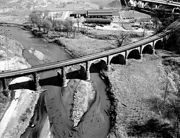
Aerial view, c. 1977

1987
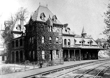
The Viaduct Hotel, 1910

B&O's Columbian, 1949
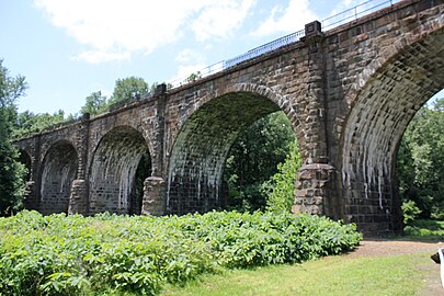
The Thomas Viaduct as seen in 2011
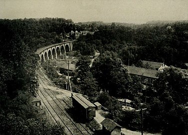
Thomas Viaduct
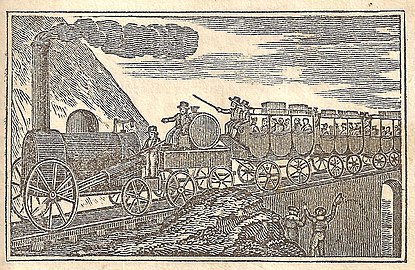
This illustration appears in a book printed in 1835, the year the viaduct opened.
See also[]
- Hockley Forge and Mill Industrial development around viaduct
- Patterson Viaduct - one of John McCartney's earlier works.
- Bloede dam - a historical hydroelectric dam located within the same park as the Thomas Viaduct.
- List of bridges documented by the Historic American Engineering Record in Maryland
- List of bridges on the National Register of Historic Places in Maryland
- List of Howard County properties in the Maryland Historical Trust
References and footnotes[]
- ^ "National Register Information System". National Register of Historic Places. National Park Service. July 9, 2010.
- ^ Jump up to: a b Yearby, Jean P. (1984). "Baltimore & Ohio Railroad, Thomas Viaduct" (PDF). Historic American Engineering Record. Washington, D.C.: Library of Congress. Retrieved April 27, 2014.
- ^ Howard County Historical Society. Images of America, Howard County. p. 17.
- ^ U.S. Office of Archaeology and Historic Preservation. The National Register of Historic Places, vol, 1, p. 193. (Washington: Government Printing Office, 1972).
- ^ Maryland Department of Natural Resources Patapsco Valley State Park. "Patapsco Valley State Park History". Archived from the original on August 9, 2007. Retrieved October 3, 2007.
- ^ Park, John R (2002). Maryland mining heritage guide: including Delaware and the District of Columbia. Miami, FL: Stonerose Pub. Co. pp. 32–33. ISBN 0970669720.
- ^ Howard County Historical Society. Images of America Howard County. p. 116.
- ^ Laura Rice. Maryland History In Prints 1743-1900. p. 81.
- ^ Patricia Heintelman (July 30, 1974). "National Historic Landmark Nomination: Thomas Viaduct". National Park Service. Cite journal requires
|journal=(help) and Accompanying photos in 1962 - ^ "Top 10 endangered historical sites in Howard County". The Baltimore Sun. 11 July 2014.
- ^ Amanda Yeager (26 May 2015). "Former school tops Howard County's endangered sites list". The Baltimore Sun.
External links[]
| Wikimedia Commons has media related to Thomas Viaduct. |
- National Historic Landmark information
- The Thomas Viaduct At Relay Maryland at archive.org
- Historic American Engineering Record (HAER) No. MD-3, "Baltimore & Ohio Railroad, Thomas Viaduct, Spanning Patapsco River, Elkridge, Howard County, MD", 18 photos, 4 data pages, 2 photo caption pages
- Thomas Viaduct Description at Maryland Historical Trust - includes 1978 photo
- Rasmussen, Frederick N. "Thomas Viaduct celebrates its 175th anniversary in July," The Baltimore Sun, Saturday, June 19, 2010.
- American Society of Civil Engineers landmark information
- Thomas Viaduct at Structurae
- Many historic and contemporary photos and images of the Thomas Viaduct
- Baltimore and Ohio Railroad bridges
- Bridges completed in 1835
- Crossings of the Patapsco River
- Railroad bridges on the National Register of Historic Places in Maryland
- CSX Transportation bridges
- Historic Civil Engineering Landmarks
- National Historic Landmarks in Maryland
- Railroad bridges in Maryland
- Viaducts in the United States
- Bridges in Baltimore County, Maryland
- Bridges in Howard County, Maryland
- Historic American Engineering Record in Maryland
- Elkridge, Maryland
- History of rail transportation in the United States
- Railroad-related National Historic Landmarks
- National Register of Historic Places in Baltimore County, Maryland
- Stone arch bridges in the United States
- 1835 establishments in Maryland


