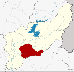
Thong Saen Khan District
Thong Saen Khan
ทองแสนขัน | |
|---|---|
 District location in Uttaradit Province | |
| Coordinates: 17°28′31″N 100°20′1″E / 17.47528°N 100.33361°ECoordinates: 17°28′31″N 100°20′1″E / 17.47528°N 100.33361°E | |
| Country | Thailand |
| Province | Uttaradit |
| Seat | Bo Thong |
| Area | |
| • Total | 745.4 km2 (287.8 sq mi) |
| Population (2005) | |
| • Total | 33,042 |
| • Density | 44.3/km2 (115/sq mi) |
| Time zone | UTC+7 (ICT) |
| Postal code | 53230 |
| Geocode | 5309 |
Thong Saen Khan (Thai: ทองแสนขัน, pronounced [tʰɔ̄ːŋ sɛ̌ːn kʰǎn]) is a district (amphoe) in the southern part of Uttaradit Province, northern Thailand.
Geography[]
Neighboring districts are (from the southwest clockwise) Phichai, Tron, Mueang Uttaradit, Tha Pla, Nam Pat of Uttaradit Province, Chat Trakan and Wat Bot of Phitsanulok Province
History[]
The minor district (king amphoe) was created on 1 July 1983, when four tambon were split off from Tron District.[1] It was upgraded to a full district on 21 May 1990.[2]
Administration[]
The district is divided into four sub-districts (tambons), which are further subdivided into 45 villages (mubans). The township (thesaban tambon) Thong Saen Khan covers parts of tambon Bo Thong. There are a further four tambon administrative organizations (TAO).
| No. | Name | Thai name | Villages | Pop. | |
|---|---|---|---|---|---|
| 1. | Phak Khuang | ผักขวง | 14 | 9,198 | |
| 2. | Bo Thong | บ่อทอง | 14 | 12,287 | |
| 3. | Pa Khai | ป่าคาย | 9 | 6,030 | |
| 4. | Nam Phi | น้ำพี้ | 8 | 5,527 |
References[]
- ^ ประกาศกระทรวงมหาดไทย เรื่อง แบ่งท้องที่อำเภอตรอน จังหวัดอุตรดิตถ์ ตั้งเป็นก��่งอำเภอทองแสนขัน (PDF). Royal Gazette (in Thai). 100 (109 ง): 2134. July 5, 1983.
- ^ พระราชกฤษฎีกาตั้งอำเภอห้วยผึ้ง อำเภอวังวิเศษ อำเภอคลองหาด อำเภอป่าบอน อำเภอหนองหญ้าปล้อง อำเภอวังโป่ง อำเภอควนเนียง อำเภอหนองหญ้าไซ อำเภอบ้านนาเดิม อำเภอทุ่งฝน อำเภอสร้างคอม และอำเภอทองแสนขัน พ.ศ. ๒๕๓๓ (PDF). Royal Gazette (in Thai). 107 (83 ก special): 1–4. May 21, 1990.
External links[]
- Amphoe of Uttaradit Province
- Uttaradit province geography stubs
