Three Brothers (Yosemite)
| Three Brothers | |
|---|---|
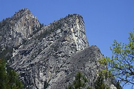 Three Brothers as seen from Valley Loop trail | |
| Highest point | |
| Elevation | 7,783 ft (2,372 m) NAVD 88[1] |
| Prominence | 379 ft (116 m)[2] |
| Coordinates | 37°44′46″N 119°36′53″W / 37.7460126°N 119.614712°WCoordinates: 37°44′46″N 119°36′53″W / 37.7460126°N 119.614712°W[1] |
| Geography | |
| Location | Yosemite National Park, Mariposa County, California, United States |
| Parent range | Sierra Nevada |
| Topo map | USGS Half Dome |
| Geology | |
| Age of rock | Cretaceous |
| Mountain type | granite rock |

The Three Brothers is a rock formation, in Yosemite Valley, California. It is located just east of El Capitan and consists of Eagle Peak (the uppermost "brother"), and Middle and Lower Brothers.[3]
The name Three Brothers[]
Members of the Mariposa Battalion named the Three Brothers after the capture of the three sons of Chief Tenaya near the base of the Three Brothers.[4]
Their original name[]
The Ahwahnechee name was "Kom-po-pai-zes", or sometimes "Pompomposus", is translated as "mountains with heads like frogs when ready to leap".[4]
John Muir[]
John Muir considered the view from Eagle Peak to be the most beautiful view of Yosemite Valley available.
References[]
- ^ Jump up to: a b "Eagle". NGS data sheet. U.S. National Geodetic Survey. Retrieved 2014-01-20.
- ^ "Eagle Peak". Peakbagger.com. Retrieved 2014-01-20.
- ^ "Rock Formations in Yosemite Valley". Yosemite National Park, National Park Service.
- ^ Jump up to: a b Richard J. Hartesveldt (1955). "Yosemite Valley Place Names". Yosemite Natural History Associatio. Retrieved 3 September 2017.
External links[]
- "Eagle Peak (Yosemite)". SummitPost.org.
| Authority control: National libraries |
|---|
This Yosemite-related article is a stub. You can help Wikipedia by . |
This Mariposa County, California–related article is a stub. You can help Wikipedia by . |
- Landforms of Mariposa County, California
- Rock formations of Yosemite National Park
- Yosemite National Park stubs
- Mariposa County, California geography stubs