Thule Site J
| Thule Site J | |
|---|---|
 Thule AN/FPS-50 detection reflectors (1959–1987)--concrete foundations included a large refrigeration system to prevent the curing concrete's heat from melting Permafrost.[citation needed] | |
 | |
| General information | |
| Type | radar structures |
| Location | 10 miles from Thule AB (13 road miles) |
| Country | Greenland |
| Coordinates | 76°34′13″N 68°17′56″W / 76.570258°N 68.298998°WCoordinates: 76°34′13″N 68°17′56″W / 76.570258°N 68.298998°W 76°34′04″N 68°17′03″W / 76.56785°N 68.284214°W AN/FPS-49A bldg[2] |
| Opened | 1958-60 (AN/FPS-50) 1963 (AN/FPS-49A) 1987 (AN/FPS-120) |

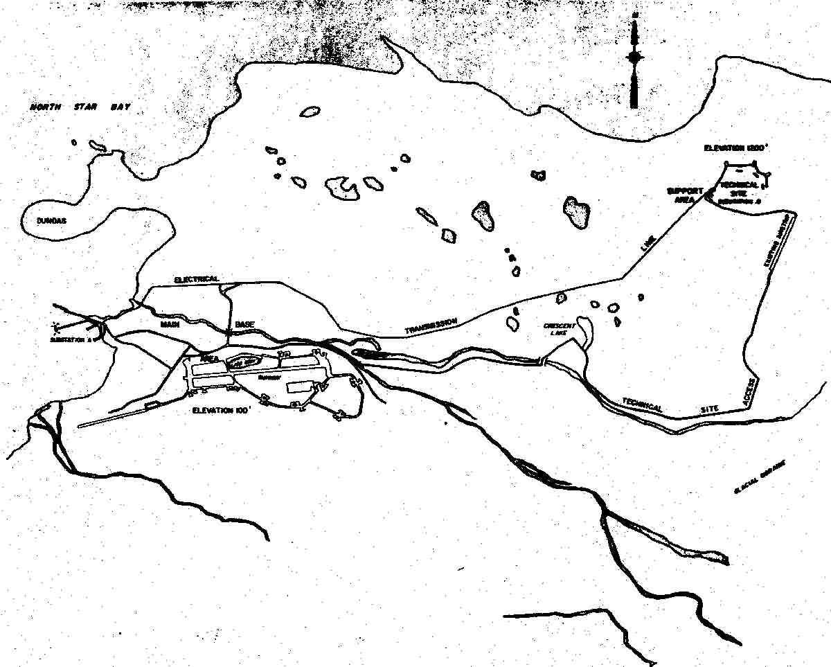
Thule Site J (J-Site) is a United States Space Force (USSF) radar station in Greenland near Thule Air Base for missile warning and spacecraft tracking. The northernmost station of the Solid State Phased Array Radar System, the military installation was built as the 1st site of the RCA 474L Ballistic Missile Early Warning System and had 5 of 12 BMEWS radars. The station has the following structures:
This list is incomplete; you can help by . (March 2014) |
- "EWR facility":[3] structure with a Solid State Phased Array Radar System (SSPARS) phased array radar[4]
- BMEWS radar buildings: 3 of the 4 former AN/FPS-50 buildings, 1 AN/FPS-49A building[2]
- Support structures: e.g., buildings with telecommunication equipment at the station's "support site" (cf. "technical site" with radar)[5]—15 major structures were complete in 1961[6] (i.e., Bldg 98 which was for the original BRCS)[7]

History[]

BMEWS 156 was issued on November 7, 1957 (BMEWS had originally been "designed to go with the active portion of the WIZARD system") and on February 4, 1958; the USAF informed Air Defense Command (ADC) that BMEWS was an "all-out program" and was "...being placed on the Department of Defense master urgency list."[8] On January 14, 1958, the US announced its "decision to establish a Ballistic Missile Early Warning System"[9] with Thule to be operational in 1959—total Thule and Clear Air Force Station costs in a May 1958 estimate were ~$800 million (an October 13, 1958, plan for both estimated completion in September 1960.)[10]
A World War II ship (freighter) operated by the company[11] originally provided the Site J electrical and heating supplies until a powerplant was constructed years later,[12] and water was from Thule AB via a branch to the site.[13]
Construction[]
Kiewit was contracted for heavy construction (e.g., the AN/FPS-50 reflector foundations[14] and tunnels between transmitter buildings),[15] and construction began in May 1958[16] (a trial reflector installation failed due to ordinary carbon steel bolts instead of 1.5% chrome steel.)[15] The maintenance building with electric heat was the first building complete; and the four AN/FPS-50 reflectors with 25-ton foundations were complete by August 8, 1959[15] ("two pedestals for trackers" were built for deferred radars.)[17] After the July 13, 1959, treaty No. 5045 with Canada regarding intermediate sites, [1] the (BRCS) was established between the "switchboard[where?] at Thule and the in New York City"—a similar line between Thule and Massachusetts used a summer 1959 "submarine cable... between Thule and "[18] ("BMEWS Rearward Long-Lines System"[19] stations were at CFS Resolution Island[20] & CFS Saglek.)[21] President Dwight D. Eisenhower was notified on April 23, 1960 of "construction work at Thule on schedule [and that] all technical buildings have been accepted and emplacement of the electronic components is underway [and] erection of the four radar antennas was completed",[22] and radar testing began on May 16, 1960[23]—a simplex vacuum tube IBM 709 used as the prototype Missile Impact Predictor (MIP) occupied 2 floors [2] (duplex IBM-709-TX solid-state computers of the Missile Impact Predictor Set were later installed in Building 2.)[24] To predict when parts "might break down",[25] the contractor also installed a "Checkout Data Processor"[3]--RCA 501 computers [4] with 32k "high speed memory", 5-76KC 556 bpi 3/4" tape drives, & 200 track random access LFE drums.[citation needed] The initial radar transmission from one of the scanner buildings was in August 1960.[5]
RCA operations[]
On the same date as the BMEWS Central Computer and Display Facility in the continental United States, "at midnight on 30 September 1960 ["BMEWS Site I"] achieved initial operational capability", and a "shakedown" period followed which used the simplex MIP and voice transmission of data to the Colorado Springs' CC&DF.[26]
- False alarms
- On October 5, 1960, when Nikita Khrushchev, the Soviet Premier, was in New York,[27] radar returns during Thule moonrise[28] produced a false alarm (on January 20, 1961, CINCNORAD approved 2-second FPS-50 frequency hoping to eliminate reception of echoes beyond artificial satellite orbits.)[29] On November 24, 1961, an AT&T operator error at their Black Forest Microwave Station northeast of Colorado Springs[30] caused a BMEWS communications outage to the Ent AFB CC&DF and its output to Strategic Air Command (a nearby B-52's overflight confirmed Site J had not been attacked.)[31]
The BRCS undersea cable from Greenland had been cut "presumably by fishing trawlers" in September, October, and November 1961 (the BMEWS teletype and backup SSB substituted)[32]--Hard Head[6] missions for continual monitoring commenced in 1961 [7] (the Bomb Alarm System had been installed at the Thule and Clear BMEWS sites by 10 February 1961.[10] After local interference (e.g., "cranes and floor waxers") and equipment problems were mitigated and a 72-hour test verified "the automatic rearward data transmission" (BRCS), the 1961 "authorization to begin fully automatic operation; effective 2400 hours GMT 31 January, was issued"[26] "Lt. Col. Harry J. Wills [was the] senior air force officer on the project at Thule" on January 3, 1961[33] ("BMEWS deputy program director" by 1964—he was reassigned from the BMEWS SPO to the "Space Track SPO"[8] on February 14, 1964.)[34]
Air Defense Command[]
Thule operations transferred from civilian contractors (RCA Government Services)[35] to Air Defense Command on January 5, 1962;[36] and 1962 sinkholes formed in the drainage ditch at "Scanner 6".[9] By mid-1962, BMEWS "quick fixes" for ECCM had been installed for Thule "to recognize when it was being jammed."[32]
An RCA AN/FPS-49A Radar Set with specialized radome for Thule weather[37] was installed by December 1963,[38] and Thule multipath testing was completed by May 1964.[39] In 1967 when the system cost totalled $1.259 billion, BMEWS modification testing ended on May 15 ("completion of the BMEWS");[34] and the Bomb Alarm System caused a false alarm during the 1968 Thule Air Base B-52 crash[10] (the system was deactivated in 1970.)[10] In June 1980, [11] Thule's FPS-49A radome by Goodyear[11] "burnt to the ground" and was rebuilt, [12] and a late 1960s satellite communications terminal was moved from the Thule P-Mountain site to Site J in 1983.[40] To replace AN/FSQ-28 predictors, a late 1970s plan for processing returns from MIRVs[41] installed new Missile Impact Predictor computers and was complete by September 1984.[34][42] After being contracted for Thule on July 29, 1983; construction of an AN/FPS-120 Early Warning Radar was started on November 7, 1984, the "array plate" was complete on June 26, 1985, and the 1st satellite track was on June 8, 1986.[34]
Solid State Phased Array Radar[]
| External media | |
|---|---|
| Images | |
| Video | |
Thule's BMEWS radars were deactivated in June 1987.[43][44] The BMEWS system at Thule had been "replaced"[45] by the SSPARS AN/FPS-120 with "two-faced…phased array radar [completed] in 2QFY87" (January–March).[46] with 240 degree detection arc[47] The AN/FPS-49A was intact and in disrepair in 1996,[16] and the antenna and radome were removed by 2014.[13] After the Danish parliament approved, [14] Raytheon was contracted in 2005 to upgrade Thule's "Early Warning Radar" as part of the larger Ground-Based Midcourse Defense program.[3] Intended to be ready in 2008, the installation was actually completed on June 24, 2009.[15] Thule's AN/FPS-132 Upgraded Early Warning Radar (UEWR) completes about 10% of the United States' observations of Earth orbiting satellites.[48]
References[]
- ^ "Missile Sites". ed-thelen.org. Retrieved 2015-05-18.
- ^ Jump up to: a b "Google Maps". Google Maps.
- ^ Jump up to: a b Upgrade to the Thule Air Base Early Warning Radar Site (FBO webpage) (Report). FedBizOpps.gov. October 8, 2005. Retrieved 2014-03-19.
- ^ "The Center for Land Use Interpretation". clui.org. Retrieved 2015-05-18.
- ^ "Thule J Site". radomes.org.
- ^ "The Milwaukee Journal - Google News Archive Search". Retrieved 2015-05-18.
- ^ "Broken Arrow -- The B-52 Accident.................. - Thuleforum". thuleforum.com. Archived from the original on 2015-05-19. Retrieved 2015-05-18.
- ^ USAF memo to Air Defense Command cited in 1958 NORAD/CONAD Historical Summary, Jan–Jun
- ^ "NORAD Selected Chronology". Federation of American Scientists. Retrieved 2014-03-05.
14 Jan 58 -- United States announced decision to establish a Ballistic Missile Early Warning System
(list also at NORAD.mil Archived 2012-09-15 at the Wayback Machine & in 2008 book - ^ Jump up to: a b c Wainstein, L. (June 1975). The Evolution of U.S. Strategic Command and Control and Warning: Part One (1945-1953) (PDF) (Report). Study S-467. Institute for Defense Analyses. pp. 1–138. Retrieved 2014-03-09.
- ^ Jump up to: a b "news article title tbd". January 5, 1961. Retrieved 2014-03-17.
Sylvania Electric Products for the data take-off unit and the missile impact predictor, and Goodyear Aircraft for the tracking radar antenna, pedestal and domes. Thule power ship was "Hull No. 2150, ., Milwaukee, 1945…built as a 5,000 ton freighter, 338 feet long, 50 broad and 21 deep. … 34,500 kilowatt steam generating plant. The floating power plant performed emergency service after hurricanes in Florida and Puerto Rico before its sides were sprayed with four inches of insulation and it was towed to Thule [for] most of the electricity [and it] feeds three miles of steam heating lines as well. …earth embankment [for] its private lagoon … roller brackets…welded to the side…run on steel pilings driven into the bottom of the bay. … A private contractor, Burns & Roe, Inc., of New York, runs the ship for RCA.
- ^ "Yahoo! Groups". groups.yahoo.com. Retrieved 2015-05-18.
- ^ Desktop Corrosion Control Study for Thule Afr Base, Greenland (Report). Retrieved 2014-03-17.
Chlorinated water is piped 10 miles to the distribution storage tanks the [Thule Tracking Station] base. … The water distribution branch that goes to the J-Site (BMEWS)
- ^ "Kiewit :: Cold War Construction". kiewit.com. Retrieved 2015-05-18.
- ^ Jump up to: a b c "BMEWS Site 1, Under Construction - 1958-1960". radomes.org. Retrieved 2015-05-18.
- ^ Jump up to: a b Hoffecker, Whorton, & Buechler. Cold War Historic Properties of the 21st Space Wing (Report). Retrieved 2014-03-20.
ADC assumed control ofThule [AB] in 1960 ... The original radar screens were dismantled in 1987 when the site was upgraded to phased-array radar. The scanner buildings and tracking radar remain intact but are not used and have fallen into disrepair. ... Cavalier AS...approximately 67 miles north of Grand Forks, and 15 miles south of the Canada–US border, near the community of Concrete. The 278-acre installation... In 1977, the operation of the PAR Site was transferred to the Air Force ADC... After the elimination of ADC in 1979, PARCS was transferred to SAC. In 1983, the site became a part of AFSPC (and was officially redesignated Cavalier AS). The land at Cavalier is leased from the Army. ...Missile Site Radar (MSR) at Grand Forks
CS1 maint: multiple names: authors list (link) - ^ Rogers, Warren Jr. (June 2, 1960). "Summit Failure Speeds Up Development of BMEWS". Herald Tribune News Service. Retrieved 2014-03-09.
- ^ "ABMWSP Summary - 23 April 1960". alternatewars.com. Retrieved 2015-05-18.
- ^ "Telecommunications (Domestic Satellite) (2 of 3 folders)" (PDF). claytwhitehead.com. October–December 1969. Retrieved 2015-05-18.
- ^ Mitchell, Walt. "Memories of Troposcatter at Resolution Island". Archived from the original on 2014-03-11. Retrieved 2014-03-09.
the BMEWS Rearward link came from Thule to Dyer to ResX1 to ResX on Resolution and then on to Goose Bay. I suspect that was the link maintained by Canadian Marconi under contract in the 1961 to 1974 period.
(see also "DEWDROP Tropospheric Scatter AM Communications Link between Thule BMEWS and Cape Dyer") - ^ "BMEWS". Archived from the original on 2010-10-05. Retrieved 2015-05-18.
- ^ Report No. 8, Progress of Anti-Ballistic Missile Weapon System Program (Summary) (Summary with Deputy Secretary of Defense cover letter) (Report). available at Eisenhower Presidential Library. Retrieved 2014-03-21.
- ^ "The Spokesman-Review - Google News Archive Search". Retrieved 2015-05-18.
- ^ "Yahoo! Groups". groups.yahoo.com. Retrieved 2015-05-18.
- ^ "Watchful eye of BMEWS turns toward Soviets" (Google news archive). Ellensburg Daily Record. June 18, 1961. Retrieved 2014-03-09.
- ^ Jump up to: a b North American Air Defense Command Historical Summary (Report).[specify]
- ^ Pearson, Drew (May 16, 1961). "A Day In The War Room At NORAD" (Google news archive). The Palm Beach Post. Retrieved 2014-03-09.
- ^ Sampson, Curt (2010-01-25). "The Moon as a Soviet Missile Attack". Retrieved 2014-03-05.
- ^ Stone & Banner. Radars for the Detection and Tracking of Ballistic Missiles, Satellites, and Planets (PDF) (Report). Retrieved 2020-06-11.
The Millstone radar served as a development model for RCA's AN/FPS-49, AN/FPS-49A, and AN/FPS-92 radars, all of which were used in the BMEWS. … Millstone was used to develop a fundamental understanding of several important environmental challenges facing the BMEWS. These challenges included the measurement of UHF propagation effects in the ionosphere, the impact of refraction close to the horizon, the effect of Faraday rotation on polarization, and the impact of backscatter from meteors and the aurora on the detection performance of the radar and its false-alarm rate [15–17]. … In the early 1960s, the Millstone radar was converted from a UHF to an L-band system. …the Air Force in the 1960s sponsored the development of Haystack, a versatile facility in Tyngsboro, Massachusetts, that supports radar- and radio-astronomy research and the national need for deep-space surveillance.
- ^ "AT&T caused NORAD blackout…" (web post of newspaper column). EVER WONDER?. Colorado Springs Gazette. 2011-08-26. Retrieved 2014-03-10.
an engineer we'll call "Q" didn't follow instructions "for routining a TD2 transmitter and receiver." He enclosed diagrams showing what went wrong. There was no "500A termination on the Channel Dropping Network when he was running the Radio Frequency (RF) Sweep Generator to adjust the equipment." That generator leaked RF into the Channel Separating Filter "interfering with all the other transmitters in the Black Forest Microwave Station, causing a complete failure of all channels going to Ent. SAC scrambled all aircraft. Later SAC billed AT&T for all the fuel used."
- ^ Philips, Alan F. "20 Mishaps That Might Have Started Accidental Nuclear War". NuclearFiles.org. Retrieved 2014-03-05.
- ^ Jump up to: a b North American Air Defense Command Historical Summary (Report).[specify] "CONAD Control Center (Thule AB, Greenland) ... During Desk Top V, an operational evaluation of the Combat Operations Center was conducted. ... At the start of the Cuban crisis, a Soviet trawler was sighted directly over the [BMEWS undersea] cable. ... BMEWS rearward communications could be substantially affected only by the simultaneous cutting of all cables."
- ^ "The Milwaukee Journal - Google News Archive Search". Retrieved 2015-05-18.
- ^ Jump up to: a b c d Del Papa, Dr. E. Michael; Warner, Mary P (October 1987). A Historical Chronology of the Electronic Systems Division 1947-1986 (PDF) (Report). Retrieved 2014-03-08.
7 November [1984] Installation of [SSPARS] radar hardware at Site I, Thule, Greenland, for the Ballistic Missile Early Warning System (BMEWS) was begun.
- ^ Shore, Bruce (Spring 1963). "the fourth state of matter". Electronics Age. RCA: 29.
- ^ "Ballistic Warning Is Aim of BMEWS" (Google news archive). The Evening News. Newburgh, New York. June 19, 1964. Retrieved 2014-03-09.
high-speed scanning switches and a massive array of feedhorns… Corp., Paramus, N.J., is the prime contractor for manning and maintaining the Thule BMEWS site.
- ^ "AN/FPS-49, 49A". Retrieved 2014-03-05.
The prototype unit operated at Moorestown, New Jersey
- ^ "Annual Report of the Secretary of Defense, The Armed Forces, pp. 14-15 ("Continental Air Defense" section)" (MDA.mil excerpt). Department of Defense Annual Report, FY 1960 (Report). Retrieved 2014-03-06.
- ^ Wall, R. B. Test Plan for BMEWS Multipath Tests at Thule Air Base Greenland for 496 System Project Office, TM-4001, The MITRE Corp., May 1964
- ^ "Newcomer's Welcome Package: Thule Air Base, Greenland: Home of the 821st Air Base Group" (PDF). militaryonesource.mil. Retrieved 2015-05-18.
- ^ Robert C. Aldridge (1983). First Strike!: The Pentagon's Strategy for Nuclear War. South End Press. p. 197. ISBN 9780896081543.
- ^ "Document Detail for IRISNUM= 01073102". airforcehistoryindex.org. Retrieved 2015-05-18.
- ^ Trip Report[s]… (abstract regarding a collection of trip reports) (Report). VOL I OF II. 1987. IRIS 01098592. Retrieved 2014-03-19.
|volume=has extra text (help) - ^ "12th Space Warning Squadron". Retrieved 2014-03-19.
The radar beam is electronically steered to a programmed location. This process, accomplished in milliseconds, increases capabilities and decreases response time. Each radar face provides 120 degrees azimuth coverage, for a total of 240 degrees coverage. The antenna is inclined +20 degrees for scan coverage of +3.5 to +85 degrees elevation. Each array face contains 3,589 antenna elements; 2,560 are active and 1,029 are inactive.
- ^ Duke, S.; Stockholm International Peace Research Institute (1989). United States Military Forces and Installations in Europe. Oxford University Press. p. 47. ISBN 9780198291329. Retrieved 2015-05-18.
- ^ "Clear Upgrade (U)". fas.org. Archived from the original on 2008-10-11. Retrieved 2015-05-18.
- ^ Hanley, Charles J--Associated Press (August 17, 1987). "Soviets, Eskimos protest Thule radar" (Google news archive). Star-News. Retrieved 2014-03-09.
The radar, a Phased Array Warning System…can "see" 3,200 miles, 200 miles farther than the old system, and has a 240-degree arc…40 degrees more than the old.
- ^ "Shelton Reaffirms Commitment to Critical but Costly Thule Base | Spac…".
- 1960 in military history
- Air Defense Command radar stations
- Aerospace Defense Command military installations
- Strategic Air Command radar stations
- Air Force Space Command radar stations
- Military installations of the United States in Greenland
- Cold War military installations in Denmark
- Military installations established in 1960
- 1960 establishments in Greenland