Ticlacayán District
Ticlacayán | |
|---|---|
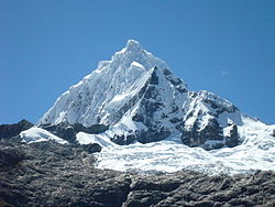 Waqurunchu | |
| Country | |
| Region | Pasco |
| Province | Pasco |
| Founded | June 14, 1958 |
| Capital | |
| Government | |
| • Mayor | Ronald David Meza Diaz |
| Area | |
| • Total | 585.1 km2 (225.9 sq mi) |
| Elevation | 3,500 m (11,500 ft) |
| Population (2005 census) | |
| • Total | 4,309 |
| • Density | 7.4/km2 (19/sq mi) |
| Time zone | UTC-5 (PET) |
| UBIGEO | 190110 |
Ticlacayán District is one of thirteen districts of the Pasco Province in the Pasco Region of Peru.[1] Its seat is Ticlacayán.
Geography[]
The Waqurunchu mountain range traverses the district. One of the highest mountains of the district is Waqurunchu at 5,748 m (18,858 ft). Other mountains are listed below:[2]
- Anka Wachanan
- Awki
- Hatun Ukru
- Kasha Pata
- Llama Lluchka
- Luychu
- Manka P'ukru
- Marayniyuq
- Mina Kasha
- Mishi Waqanan
- Muruqucha
- Ñawsan
- Ñawsaqucha
- Parya Punta
- Puka Uru
- Puma Hirka
- Puma Wayin
- Qaqa Mach'ay
- Qiwllaqucha
- Ranra Tampu
- Raqray
- Saqra Mach'ay
- Shaywa Punta
- Tampu Raqra
- T'uru Hirka
- Wachwa Rumi
- Wank'a Wank'a
- Waqay Rumi
- Waqurunchu (Huá.-Pas.)
- Yana Chuku
- Yanaqucha
- Yuraq Mit'u
References[]
- ^ (in Spanish) Instituto Nacional de Estadística e Informática. Banco de Información Distrital Archived 2008-04-23 at the Wayback Machine. Retrieved April 11, 2008.
- ^ escale.minedu.gob.pe - UGEL map of the Pasco Province (Pasco Region)
| |
|---|---|
| Daniel Alcides Carrión | |
| Oxapampa | |
| Pasco | |
This Pasco Region geography article is a stub. You can help Wikipedia by . |

Categories:
- Districts of the Pasco Region
- Districts of the Pasco Province
- Pasco Region geography stubs