Timoteo Domínguez Island
This article needs additional citations for verification. (September 2013) |
Isla Timoteo Domínguez | |
|---|---|
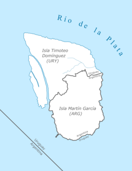 Diagram of Timoteo Domínguez and Martín García Islands | |
| Geography | |
| Location | Río de la Plata |
| Coordinates | 34°10.2′S 58°15.4′W / 34.1700°S 58.2567°WCoordinates: 34°10.2′S 58°15.4′W / 34.1700°S 58.2567°W |
| Administration | |
| Department | Colonia |
| Demographics | |
| Population | 0 |

Timoteo Domínguez Island (Spanish: Isla Timoteo Domínguez) is an Uruguayan island off the Río de la Plata coast of Uruguay.
The Argentine exclave Martín García island is within the boundaries of Uruguayan waters; in 1973 both countries reached an agreement establishing Martín García as an Argentine territory and also as a nature reserve. In recent decades, river sediments gave birth to the very first dry limit between Argentina and Uruguay: the islands Martín García and Timoteo Domínguez are united.[1]
References[]
| Wikimedia Commons has media related to Isla Timoteo Domínguez. |
This article about a location in Uruguay is a stub. You can help Wikipedia by . |
This article about an island is a stub. You can help Wikipedia by . |
Categories:
- River islands of Uruguay
- Islands of the Río de la Plata
- Argentina–Uruguay border
- Uruguay geography stubs
- Island stubs