Tjørnuvík
Tjørnuvík | |
|---|---|
Village | |
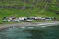
 Tjørnuvík seen from Eidiskollur. | |
 Tjørnuvík Location in the Faroe Islands | |
| Coordinates: 62°17′17″N 7°8′27″W / 62.28806°N 7.14083°WCoordinates: 62°17′17″N 7°8′27″W / 62.28806°N 7.14083°W | |
| Country | |
| Island | Streymoy |
| Municipality | Sunda Municipality |
| Population (1 January 2006) | |
| • Total | 71 |
| Time zone | GMT |
| • Summer (DST) | UTC+1 (EST) |
| Postal code | FO 445 |
| Climate | ET |

Tjørnuvík (Danish: Tjørnevig) is the northernmost village on Streymoy in Sunda Municipality, Faroe Islands.
The 2015 population was 54. Its postal code is FO 445. Its current church was built in 1937.
Gallery[]


See also[]
External links[]
This Faroe Islands location article is a stub. You can help Wikipedia by . |
Categories:
- Populated places in the Faroe Islands
- Faroe Islands geography stubs