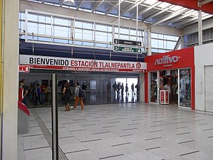
Tlalnepantla railway station
| Commuter rail | ||||||||||||||||||||||||||||||||||||||||||||||||||||||||||||||||||||||
 | ||||||||||||||||||||||||||||||||||||||||||||||||||||||||||||||||||||||
| Location | Tlalnepantla, State of Mexico Mexico | |||||||||||||||||||||||||||||||||||||||||||||||||||||||||||||||||||||
| Coordinates | 19°32′11.9″N 99°11′02.2″W / 19.536639°N 99.183944°WCoordinates: 19°32′11.9″N 99°11′02.2″W / 19.536639°N 99.183944°W | |||||||||||||||||||||||||||||||||||||||||||||||||||||||||||||||||||||
| Owned by | Ferrocarriles Suburbanos | |||||||||||||||||||||||||||||||||||||||||||||||||||||||||||||||||||||
| Operated by | Ferrocarriles Suburbanos | |||||||||||||||||||||||||||||||||||||||||||||||||||||||||||||||||||||
| Platforms | 1 island platform | |||||||||||||||||||||||||||||||||||||||||||||||||||||||||||||||||||||
| Tracks | 2 | |||||||||||||||||||||||||||||||||||||||||||||||||||||||||||||||||||||
| Construction | ||||||||||||||||||||||||||||||||||||||||||||||||||||||||||||||||||||||
| Structure type | At grade | |||||||||||||||||||||||||||||||||||||||||||||||||||||||||||||||||||||
| Disabled access | Yes | |||||||||||||||||||||||||||||||||||||||||||||||||||||||||||||||||||||
| History | ||||||||||||||||||||||||||||||||||||||||||||||||||||||||||||||||||||||
| Opened | 2 June 2008 | |||||||||||||||||||||||||||||||||||||||||||||||||||||||||||||||||||||
| Services | ||||||||||||||||||||||||||||||||||||||||||||||||||||||||||||||||||||||
| ||||||||||||||||||||||||||||||||||||||||||||||||||||||||||||||||||||||
| ||||||||||||||||||||||||||||||||||||||||||||||||||||||||||||||||||||||
| Location | ||||||||||||||||||||||||||||||||||||||||||||||||||||||||||||||||||||||
 Tlalnepantla Location within Greater Mexico City | ||||||||||||||||||||||||||||||||||||||||||||||||||||||||||||||||||||||
 | ||||||||||||||||||||||||||||||||||||||||||||||||||||||||||||||||||||||
| Area map | ||||||||||||||||||||||||||||||||||||||||||||||||||||||||||||||||||||||
Tlalnepantla is a commuter railway station serving the Ferrocarril Suburbano, a suburban rail that connects the State of Mexico with Mexico City. The station is located in the municipality of Tlalnepantla, State of Mexico, north of Mexico City.[1]
General information[]
Tlalnepantla station is located between the San Javier and Ceylan neighborhoods in the Tlalnepantla municipality, State of Mexico. It is the third station of the system going northbound from Buenavista and the first one to be located in the State of Mexico. The station is located relatively close to downtown Tlalnepantla.[1]
As with Mexico City Metro, each station of the Ferrocarril Suburbano has a pictogram. Tlalnepantla's pictogram depicts the façade of the pyramid of Santa Cecilia Acatitlán, an archeological zone in Tlalnepantla discovered between 1923 and 1924.[2][3]
The station opened on 2 June 2008 as part of the first stretch of system 1 of the Ferrocarril Suburbano, going from Buenavista in Mexico City to the Lechería station in the State of Mexico.[4]
Station layout[]
| G | Street Level | Exits/Entrances |
| G Platforms |
Northbound | ← |
| Island platform, doors will open on the left | ||
| Southbound | | |
References[]
- ^ a b "Ferrocarriles Suburbanos - Estaciones". fsuburbanos.com. Retrieved 1 April 2020.
- ^ "Cercanías en México para cien millones de viajeros al año" (PDF) (in Spanish). Ineco. December 2008. Archived from the original (PDF) on 1 July 2010. Retrieved 1 April 2020.
{{cite magazine}}: Cite magazine requires|magazine=(help) - ^ "Zona Arqueológica Santa Cecilia Acatitlán". inah.gob.mx (in Spanish). Instituto Nacional de Antropología e Historia. Retrieved 1 April 2020.
- ^ "Tren Suburbano inaugurated". Railway Gazette International. 1 July 2008. Archived from the original on 16 April 2019. Retrieved 1 April 2020.
| Wikimedia Commons has media related to Tlalnepantla Station. |
- 2008 establishments in Mexico
- Tren Suburbano stations
- Railway stations opened in 2008
- Tlalnepantla de Baz
