Todarpur, Hardoi
Todarpur
Tondarpur | |
|---|---|
Populated place | |
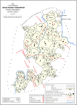 Map showing Todarpur (#366) in Todarpur CD block | |
 Todarpur Location in Uttar Pradesh, India | |
| Coordinates: 27°33′20″N 80°01′30″E / 27.555476°N 80.025084°ECoordinates: 27°33′20″N 80°01′30″E / 27.555476°N 80.025084°E[1] | |
| Country | |
| State | Uttar Pradesh |
| District | Hardoi |
| Area | |
| • Total | 4.282 km2 (1.653 sq mi) |
| Population (2011)[2] | |
| • Total | 3,846 |
| • Density | 900/km2 (2,300/sq mi) |
| Languages | |
| • Official | Hindi |
| Time zone | UTC+5:30 (IST) |


Todarpur, also spelled Tondarpur, is a village and corresponding community development block in Shahabad tehsil of Hardoi district, Uttar Pradesh, India.[2] The village has several schools and one clinic.[2] It hosts neither a haat nor a (regular market).[2] The staple crops here are wheat and rice.[3] As of 2011, its population is 3,846, in 603 households.[2]
The village is the site of an old Thathera , and was historically the seat of the Onai branch of the Chamar Gaurs.[4]
Demographic history[]
The 1961 Census recorded Todarpur as comprising 3 hamlets and having a population of 1,532 (853 male and 679 female), in 282 households and 208 physical houses.[5]
The 1981 Census recorded Todarpur as having an area of 433.43 hectares and having a population of 2,088 people, in 449 households.[3]
Villages[]
Todarpur CD block has the following 115 villages:[2]
| Village name | Total land area (hectares) | Population (in 2011) |
|---|---|---|
| 520.5 | 2,224 | |
| 342 | 1,906 | |
| 66.9 | 435 | |
| 450 | 2,186 | |
| 270.1 | 2,178 | |
| 303.4 | 1,639 | |
| 911.7 | 4,928 | |
| 273.5 | 1,716 | |
| 286.8 | 1,406 | |
| 723.1 | 2,967 | |
| 1,018.9 | 5,339 | |
| 126 | 1,188 | |
| 664.7 | 3,877 | |
| 33.1 | 936 | |
| 161.5 | 808 | |
| 156.1 | 1,131 | |
| 266 | 764 | |
| 83.8 | 740 | |
| 142.1 | 1,188 | |
| 398.1 | 2,377 | |
| 335.1 | 2,141 | |
| 158.2 | 793 | |
| 513.6 | 2,812 | |
| 1,435.9 | 6,866 | |
| 440.8 | 1,656 | |
| 945.4 | 8,948 | |
| 235 | 1,271 | |
| 304 | 1,635 | |
| 117.7 | 1,004 | |
| 745.7 | 4,049 | |
| 275.4 | 594 | |
| 164.4 | 694 | |
| 550.2 | 8,429 | |
| 71.7 | 1,127 | |
| 237.2 | 897 | |
| 107.9 | 669 | |
| 264.5 | 2,157 | |
| 194.6 | 750 | |
| 274.2 | 1,209 | |
| 282.5 | 2,172 | |
| 110.1 | 620 | |
| Fatehpur Gayand | 633 | 3,635 |
| 114.8 | 942 | |
| 261 | 2,015 | |
| 242.6 | 825 | |
| 111.1 | 1,565 | |
| 281.7 | 2,784 | |
| 228.1 | 1,141 | |
| 661.8 | 2,857 | |
| 47.8 | 359 | |
| 158.9 | 390 | |
| 180.4 | 1,365 | |
| 247.2 | 944 | |
| Dighia | 212 | 899 |
| 135.6 | 590 | |
| 110.4 | 576 | |
| 467.4 | 3,682 | |
| 165.7 | 987 | |
| 687.1 | 3,189 | |
| 650.6 | 3,924 | |
| 90 | 1,258 | |
| 277.6 | 1,196 | |
| 153.4 | 1,175 | |
| 78.8 | 436 | |
| 212.7 | 456 | |
| 293.1 | 2,727 | |
| 145.9 | 855 | |
| 195.7 | 1,407 | |
| 192.7 | 977 | |
| 59.2 | 469 | |
| 256 | 1,331 | |
| 149.1 | 341 | |
| 168.6 | 644 | |
| 75 | 621 | |
| 105.1 | 527 | |
| 85.4 | 515 | |
| 395.1 | 3,380 | |
| 80.2 | 81 | |
| 101.6 | 2,780 | |
| 163.6 | 1,024 | |
| 73.2 | 0 | |
| 312 | 2,989 | |
| 135.4 | 172 | |
| 228 | 591 | |
| 220.9 | 1,364 | |
| 481 | 2,590 | |
| 118.7 | 638 | |
| 68.2 | 363 | |
| 43.7 | 0 | |
| 82.1 | 974 | |
| 162.8 | 707 | |
| 111.8 | 578 | |
| 127.1 | 775 | |
| Todarpur | 428.2 | 3,846 |
| 251.4 | 1,774 | |
| 139.2 | 1,186 | |
| 155.8 | 1,086 | |
| 364.2 | 2,126 | |
| 513.1 | 3,204 | |
| 493.3 | 2,761 | |
| 164.6 | 585 | |
| 52.8 | 0 | |
| 65.1 | 377 | |
| 287.9 | 1,229 | |
| 157.6 | 1,114 | |
| 68.1 | 182 | |
| 186.9 | 1,300 | |
| 27.8 | 0 | |
| 42.4 | 375 | |
| 75.3 | 1,163 | |
| 329.5 | 1,635 | |
| 66.6 | 255 | |
| 168.1 | 948 | |
| 85.9 | 697 | |
| 57 | 347 |
References[]
- ^ Search for "Todarpur" here https://geonames.nga.mil/namesgaz/. Missing or empty
|title=(help) - ^ a b c d e f g "Census of India 2011: Uttar Pradesh District Census Handbook - Hardoi, Part A (Village and Town Directory)" (PDF). Census 2011 India. pp. 99–123. Retrieved 18 May 2021.
- ^ a b Census 1981 Uttar Pradesh: District Census Handbook Part XIII-A: Village & Town Directory, District Hardoi (PDF). 1982. pp. 74–5. Retrieved 19 May 2021.
- ^ Nevill, H.R. (1904). Hardoi - A Gazetteer. Allahabad: Government Press. p. 258-74. Retrieved 18 May 2021.
- ^ Census 1961: District Census Handbook, Uttar Pradesh (36 - Hardoi District) (PDF). Lucknow. 1965. pp. xxvii-xxviii of section "Shahabad Tahsil". Retrieved 19 May 2021.
- Villages in Hardoi district