Tolipir
Tolipir | |
|---|---|
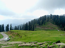
 View of Toli pir per top | |
| Country | |
| Administrative Territory | |
| District | Poonch District |
| Town | Rawalakot |

Tolipir (Urdu: تولی پیر) is a hilltop area situated in Tehsil Rawalakot in the Poonch District of Azad Kashmir. Its approximate elevation is about 8800 ft above sea level. It is about 30 km, or a 120-minute drive, from Rawalakot in Azad Kashmir.[1] Abbaspur, Bagh and Poonch River can be viewed from Toli Pir.
Tolipir is the highest mountainous location in the northeastern area of Rawalakot; it is the point of origin of three different mountain ridges. The tourist rest house on the way to Toli Pir is also situated in a scenic location.[citation needed] There are some remains of an old mazar on the highest hilltop.[2]
Tolipir is most accessible during the summer months; the weather generally becomes colder from October through March.[citation needed]

External links[]
| Wikimedia Commons has media related to Toli Pir. |
References[]

- Hill stations in Pakistan
- Hills of Pakistan
- Populated places in Poonch District, Pakistan
- Rawalakot
- National parks of Pakistan
- Tourist attractions in Azad Kashmir
- Landforms of Azad Kashmir