Tollington (ward)
This article uses bare URLs, which may be threatened by link rot. (May 2021) |
Tollington | |
|---|---|
electoral ward | |
| Coordinates: 51°33′58″N 0°07′16″W / 51.566°N 0.121°WCoordinates: 51°33′58″N 0°07′16″W / 51.566°N 0.121°W | |
| Country | United Kingdom |
| Constituent country | England |
| Region | London |
| County | Greater London |
| London borough | Islington |

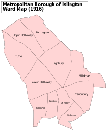
Tollington Ward is one of sixteen electoral divisions of the London Borough of Islington and is one of the eight that make up the Islington North constituency. The population of this ward at the 2011 Census was 13,211.[1]
It is the only other place in the historic parish of Islington mentioned in the Domesday Book (in the old form Tolentone) as a separate manor. The manor house was located beside present day Hornsey Road (known as Tollington Lane as late as 1740) and was purchased in 1271 by the priory of St John at Clerkenwell after which the manor's name fell into disuse.[2]
The ward is represented in the Borough's council by three councillors whose elections are held every four years. The ward is a very safe Labour seat, and stayed Labour even during the years when Islington Council was won by the Liberal Democrats. As of January 2022, the councillors are Milk Gilgunn, Anjna Khurana and Flora Williamson.[3]
References[]
- ^ "Islington Ward population 2011". Neighbourhood Statistics. Office for National Statistics. Retrieved 24 October 2016.
- ^ Thornbury, Walter (1878). Old and New London. Chapter XXXIV. pp. 273–9.
- ^ "Tollington ward councillors". Islington LBC. Retrieved 16 January 2022.
External links[]
- Wards of the London Borough of Islington