Tortuguero Volcano
| Tortuguero Volcano | |
|---|---|
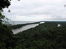 View towards the southeast from Tortuguero Volcano | |
| Highest point | |
| Elevation | 119 metres (390 ft) |
| Coordinates | 10°35′04″N 83°31′40″W / 10.584327°N 83.527759°WCoordinates: 10°35′04″N 83°31′40″W / 10.584327°N 83.527759°W |
| Geography | |
 Tortuguero Volcano Costa Rica | |
| Geology | |
| Mountain type | Volcano |
| Last eruption | Unknown |

Tortuguero Volcano, also known as Tortuguero Hill (Spanish: Cerro Tortuguero), is an extinct volcano located 5.5 kilometres (3.4 mi) WNW from Tortuguero, Costa Rica.[1][2]
Toponymy[]
It shares the name with the town and the Tortuguero National Park, which means "many turtles".[1]
Physical aspects[]
Pyroclastic cone, one of its sides was cut when the nearby canals were created.[1]
Social and economic activity[]
The volcano can be seen from the touristic areas of Tortuguero.
See also[]
References[]
- ^ a b c Alvarado Induni, Guillermo. Los volcanes de Costa Rica. Editorial de la Universidad Estatal a Distancia. pp. 200–201. ISBN 978-9968-316-79-8.
- ^ "Volcanes de Costa Rica". RSN UCR. Retrieved 11 April 2020.
External links[]
- "Tortuguero". Global Volcanism Program. Smithsonian Institution. Retrieved 2021-06-27.
| Cordillera de Guanacaste | ||
|---|---|---|
| Cordillera de Tilarán | ||
| Cordillera Central | ||
Mountains of Costa Rica | ||
|---|---|---|
| ||
| Guatemala |  | |
|---|---|---|
| El Salvador | ||
| Nicaragua | ||
| Costa Rica |
| |
| Panama | ||
Note: volcanoes are ordered from north-west to south-east. | ||
Categories:
- Stratovolcanoes of Costa Rica
- Mountains of Costa Rica
- Geography of Limón Province
- Pleistocene volcanoes