Tour du Marboré
This article relies largely or entirely on a single source. (February 2020) |
| Tour du Marboré | |
|---|---|
 Vue de la face sud en été | |
| Highest point | |
| Elevation | 3,009 m (9,872 ft)[1] |
| Prominence | 103 m (338 ft) |
| Listing | List of Pyrenean three-thousanders |
| Coordinates | 42°41′08″N 0°01′02″E / 42.68556°N 0.01722°ECoordinates: 42°41′08″N 0°01′02″E / 42.68556°N 0.01722°E[1] |
| Geography | |
 Tour du Marboré Location in the Pyrenees | |
| Location | France — Spain |
| Région | Midi-Pyrénées |
| Département | Hautes-Pyrénées |
| Parent range | (Pyrenees) |
Tour du Marboré or Tour de Gavarnie is a pyrenean summit, culminating at 3,009 m (9,872 ft), located on the Franco-Spanish border crest in the Monte Perdido Range.
from east (left) to west (right) : Pic du Marboré, the three Cascade Peaks, Épaule du Marboré, Tour du Marboré, Casque du Marboré and refuge des Sarradets; left: Gavarnie Falls. n°1 - n°2
Toponymy[]
see: Cilindro de Marboré
Topography[]
The Tour du Marboré is part of the range above Cirque de Gavarnie. It marks the border between the Pyrenees National Park of France and the Ordesa y Monte Perdido National Park of Spain.
- On the French side, it is located in the commune of Gavarnie in the canton of Luz-Saint-Sauveur, Hautes-Pyrénées department, Midi-Pyrénées region.
- On the Spanish side, it is located in the comarca of Sobrarbe, Huesca province, Aragon.

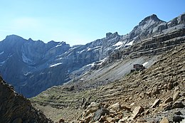
French side view of La Tour du Marboré.
Mountaineering[]
In 1956, it was climbed from the northern side by Jean Ravier and Claude Dufourmantelle.
References[]
- ^ a b Source : cartes IGN à l'échelle 1:25000 sur Géoportail
Categories:
- Mountains of the Pyrenees
- Mountains of Hautes-Pyrénées
- Mountains of Aragon
- Pyrenean three-thousanders